![](/images/other/stat-length.png)
![Tocht Mountainbike Mandelieu-la-Napoule - Estérel 03-02-13 - Photo](https://media.geolcdn.com/t/1900/400/ext.pjpeg?maxdim=2&url=https%3A%2F%2Fstatic1.geolcdn.com%2Fsiteimages%2Fupload%2Ffiles%2F1524743154velo.jpg)
Estérel 03-02-13
philsutter
Gebruiker
![Lengte](/images/other/stat-length.png)
Lengte
31 km
![Max. hoogte](https://static1.geolcdn.com/siteimages/upload/files/1508320355ic_sort_altitude_max_24dp.png)
Max. hoogte
441 m
![Positief hoogteverschil](https://static1.geolcdn.com/siteimages/upload/files/1508320355ic_sort_den_pos_24dp.png)
Positief hoogteverschil
875 m
![Km-Effort](/images/other/stat-length.png)
Km-Effort
43 km
![Min. hoogte](https://static1.geolcdn.com/siteimages/upload/files/1508320355ic_sort_altitude_min_24dp.png)
Min. hoogte
3 m
![Negatief hoogteverschil](https://static1.geolcdn.com/siteimages/upload/files/1508320355ic_sort_den_neg_24dp.png)
Negatief hoogteverschil
875 m
![Boucle](https://static1.geolcdn.com/siteimages/upload/files/16400158638029165_repeat_loop_refresh_sync_direction_icon.png)
Boucle
Ja
Datum van aanmaak :
2014-12-10 00:00:00.0
Laatste wijziging :
2014-12-10 00:00:00.0
![Mountainbike](https://static1.geolcdn.com/sitytour/trail-icons/202.png)
2h56
Moeilijkheid : Medium
![Scan deze QR-code om de tocht te openen in de SityTrail-applicatie](https://capi.geolives.com/qq0zvz2zws4bq2lad0pu/sitytour/trails/174011/qr.png?size=200)
Gratisgps-wandelapplicatie
Over ons
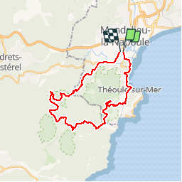
Tocht Mountainbike van 31 km beschikbaar op Provence-Alpes-Côte d'Azur, Alpes-Maritimes, Mandelieu-la-Napoule. Deze tocht wordt voorgesteld door philsutter.
Beschrijving
Estérel par le Col de Théoule, Col Notre Dame, Lac de l'Écureuil, Col de Suvières, Baisse Violette, Trois Termes
Plaatsbepaling
Land:
France
Regio :
Provence-Alpes-Côte d'Azur
Departement/Provincie :
Alpes-Maritimes
Gemeente :
Mandelieu-la-Napoule
Locatie:
Unknown
Vertrek:(Dec)
Vertrek:(UTM)
333010 ; 4822044 (32T) N.
Opmerkingen
Wandeltochten in de omgeving
![Tocht Stappen Mandelieu-la-Napoule - Mont Saint Martin - Photo](https://media.geolcdn.com/t/375/260/ext.jpg?maxdim=2&url=https%3A%2F%2Fservices.sitytrail.com%2FGeolivesWS%2FDownloadMedia.ashx%3FTrailID%3D203071%26Media%3Dfix__20130706124443.jpg)
![Stappen Stappen](https://static1.geolcdn.com/sitytour/trail-icons/101.png)
Mont Saint Martin
Stappen
Gemakkelijk
(1)
Mandelieu-la-Napoule,
Provence-Alpes-Côte d'Azur,
Alpes-Maritimes,
France
![](/images/other/stat-length.png)
9 km | 14,2 km-effort
3h 0min
![](https://static1.geolcdn.com/siteimages/upload/files/16400158638029165_repeat_loop_refresh_sync_direction_icon.png)
Ja
![Tocht Te voet Théoule-sur-Mer - Tracé Rocher des Monges par col de Théoule - Photo](https://media.geolcdn.com/t/375/260/ext.jpg?maxdim=2&url=https%3A%2F%2Fstatic1.geolcdn.com%2Fsiteimages%2Fupload%2Ffiles%2F1545311037marcheuse_200dpi.jpg)
![Te voet Te voet](https://static1.geolcdn.com/sitytour/trail-icons/100.png)
Tracé Rocher des Monges par col de Théoule
Te voet
Heel gemakkelijk
(1)
Théoule-sur-Mer,
Provence-Alpes-Côte d'Azur,
Alpes-Maritimes,
France
![](/images/other/stat-length.png)
7,2 km | 11,2 km-effort
Onbekend
![](https://static1.geolcdn.com/siteimages/upload/files/16400158638029165_repeat_loop_refresh_sync_direction_icon.png)
Ja
![Tocht Stappen Théoule-sur-Mer - Théoule-sur-mer - Grosses Grues - Photo](https://media.geolcdn.com/t/375/260/ext.jpg?maxdim=2&url=https%3A%2F%2Fservices.sitytrail.com%2FGeolivesWS%2FDownloadMedia.ashx%3FTrailID%3D435398%26Media%3Dfix__20150608121929.jpg)
![Stappen Stappen](https://static1.geolcdn.com/sitytour/trail-icons/101.png)
Théoule-sur-mer - Grosses Grues
Stappen
Medium
Théoule-sur-Mer,
Provence-Alpes-Côte d'Azur,
Alpes-Maritimes,
France
![](/images/other/stat-length.png)
14,7 km | 23 km-effort
4h 30min
![](https://static1.geolcdn.com/siteimages/upload/files/16400158638029165_repeat_loop_refresh_sync_direction_icon.png)
Ja
![Tocht Stappen Mandelieu-la-Napoule - Grand Duc Alternatif - Photo](https://media.geolcdn.com/t/375/260/ext.jpg?maxdim=2&url=https%3A%2F%2Fstatic1.geolcdn.com%2Fsiteimages%2Fupload%2Ffiles%2F1553511878bg_sport_marche.png)
![Stappen Stappen](https://static1.geolcdn.com/sitytour/trail-icons/101.png)
Grand Duc Alternatif
Stappen
Heel gemakkelijk
(1)
Mandelieu-la-Napoule,
Provence-Alpes-Côte d'Azur,
Alpes-Maritimes,
France
![](/images/other/stat-length.png)
6,4 km | 9,1 km-effort
2h 0min
![](https://static1.geolcdn.com/siteimages/upload/files/16400158638029165_repeat_loop_refresh_sync_direction_icon.png)
Ja
![Tocht Stappen Mandelieu-la-Napoule -](https://media.geolcdn.com/t/375/260/b86348bf-abb5-455a-82e4-681ad648fdf1.jpg&format=jpg&maxdim=2)
![Stappen Stappen](https://static1.geolcdn.com/sitytour/trail-icons/101.png)
"Les oeufs de bouc"
Stappen
Medium
Mandelieu-la-Napoule,
Provence-Alpes-Côte d'Azur,
Alpes-Maritimes,
France
![](/images/other/stat-length.png)
14,5 km | 22 km-effort
6h 42min
![](https://static1.geolcdn.com/siteimages/upload/files/16400158638029165_repeat_loop_refresh_sync_direction_icon.png)
Ja
![Tocht Stappen Mandelieu-la-Napoule - Grand Duc - Photo](https://media.geolcdn.com/t/375/260/bb4952b6-32f3-40dd-b274-07cfc3d80de4.jpg&format=jpg&maxdim=2)
![Stappen Stappen](https://static1.geolcdn.com/sitytour/trail-icons/101.png)
Grand Duc
Stappen
Medium
Mandelieu-la-Napoule,
Provence-Alpes-Côte d'Azur,
Alpes-Maritimes,
France
![](/images/other/stat-length.png)
8,9 km | 12,5 km-effort
2h 47min
![](https://static1.geolcdn.com/siteimages/upload/files/16400158638029165_repeat_loop_refresh_sync_direction_icon.png)
Ja
![Tocht Stappen Mandelieu-la-Napoule - châteaux de la Napoule - Photo](https://media.geolcdn.com/t/375/260/0390d912-0cc3-4a3a-a76c-b7a4f5d42e4b.jpg&format=jpg&maxdim=2)
![Stappen Stappen](https://static1.geolcdn.com/sitytour/trail-icons/101.png)
châteaux de la Napoule
Stappen
Gemakkelijk
Mandelieu-la-Napoule,
Provence-Alpes-Côte d'Azur,
Alpes-Maritimes,
France
![](/images/other/stat-length.png)
5,6 km | 7,8 km-effort
2h 23min
![](https://static1.geolcdn.com/siteimages/upload/files/16400158638029165_repeat_loop_refresh_sync_direction_icon.png)
Ja
![Stappen Stappen](https://static1.geolcdn.com/sitytour/trail-icons/101.png)
Théoule - Col de Théoule - ND d'Afrique - Pointe de L'Aiguille
Stappen
Gemakkelijk
Théoule-sur-Mer,
Provence-Alpes-Côte d'Azur,
Alpes-Maritimes,
France
![](/images/other/stat-length.png)
9,9 km | 14,9 km-effort
3h 23min
![](https://static1.geolcdn.com/siteimages/upload/files/16400158638029165_repeat_loop_refresh_sync_direction_icon.png)
Ja
![Tocht sport Mandelieu-la-Napoule - Forêt du Grand Duc - Tanneron - Photo](https://media.geolcdn.com/t/375/260/7bb7e263-3977-4a9c-b288-461d3af61f13.jpg&format=jpg&maxdim=2)
Forêt du Grand Duc - Tanneron
sport
Heel gemakkelijk
(1)
Mandelieu-la-Napoule,
Provence-Alpes-Côte d'Azur,
Alpes-Maritimes,
France
![](/images/other/stat-length.png)
8,4 km | 12,1 km-effort
Onbekend
![](https://static1.geolcdn.com/siteimages/upload/files/16400158638029165_repeat_loop_refresh_sync_direction_icon.png)
Ja