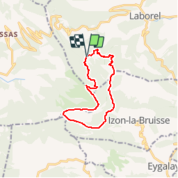
![](/images/other/stat-length.png)
![Tocht Stappen Laborel - Crête de Chamouse - Laborel - Photo](https://media.geolcdn.com/t/1900/400/ext.pjpeg?maxdim=2&url=https%3A%2F%2Fservices.sitytrail.com%2FGeolivesWS%2FDownloadMedia.ashx%3FTrailID%3D173182%26Media%3D14764_6.jpg)
Crête de Chamouse - Laborel
tracegps
Gebruiker
![Lengte](/images/other/stat-length.png)
![Max. hoogte](https://static1.geolcdn.com/siteimages/upload/files/1508320355ic_sort_altitude_max_24dp.png)
![Positief hoogteverschil](https://static1.geolcdn.com/siteimages/upload/files/1508320355ic_sort_den_pos_24dp.png)
![Km-Effort](/images/other/stat-length.png)
![Min. hoogte](https://static1.geolcdn.com/siteimages/upload/files/1508320355ic_sort_altitude_min_24dp.png)
![Negatief hoogteverschil](https://static1.geolcdn.com/siteimages/upload/files/1508320355ic_sort_den_neg_24dp.png)
![Boucle](https://static1.geolcdn.com/siteimages/upload/files/16400158638029165_repeat_loop_refresh_sync_direction_icon.png)
![Stappen](https://static1.geolcdn.com/sitytour/trail-icons/101.png)
3h30
Moeilijkheid : Medium
![Scan deze QR-code om de tocht te openen in de SityTrail-applicatie](https://capi.geolives.com/qq0zvz2zws4bq2lad0pu/sitytour/trails/173182/qr.png?size=200)
Gratisgps-wandelapplicatie
Over ons
Tocht Stappen van 11,4 km beschikbaar op Auvergne-Rhône-Alpes, Drôme, Laborel. Deze tocht wordt voorgesteld door tracegps.
Beschrijving
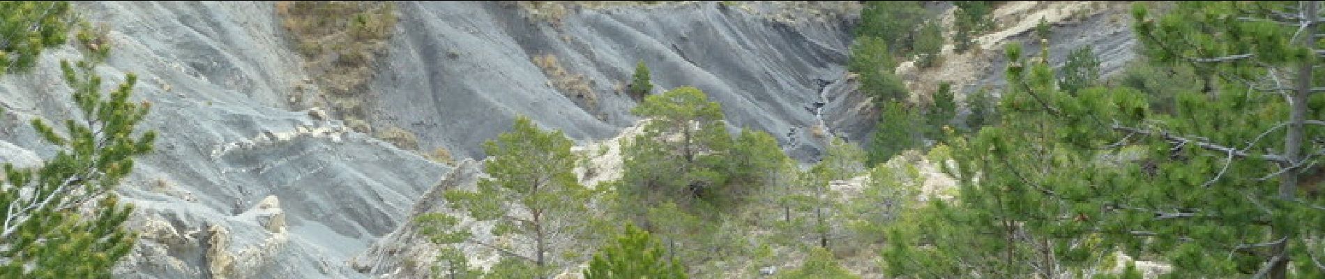
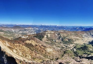
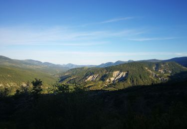
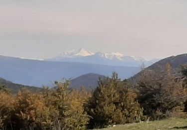
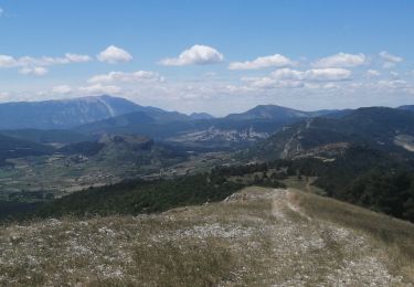
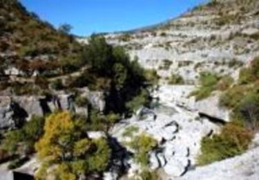
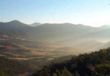
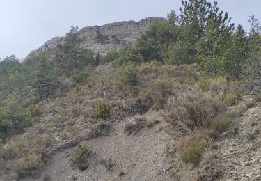
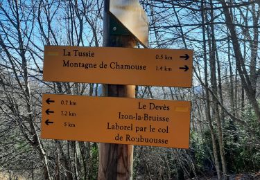
Traversée d'une belle forêt avant la crête avec de magnifiques vues. Parking au dessus de la ferme des Jouve (chemin forestier). Le chemin part au sud et traverse une belle forêt de fayards avant d'atteindre la crête. La prendre à gauche dans les prairies et la suivre jusqu'au Col d'Izon. Descendre dans la forêt vers le Col de Tous les Vents, suivre le balisage dans la forêt et remonter à flanc de la montagne d'Herc puis retour à la voiture. Belle et bonne rando !
Plaatsbepaling
Opmerkingen
Wandeltochten in de omgeving
![Tocht Stappen Laborel - Montagne de Chamouse - Photo](https://media.geolcdn.com/t/375/260/6ca43a5e-7183-48f1-b61e-fd0f610bad24.jpg&format=jpg&maxdim=2)
![Stappen Stappen](https://static1.geolcdn.com/sitytour/trail-icons/101.png)
Stappen
![](/images/other/stat-length.png)
![](https://static1.geolcdn.com/siteimages/upload/files/16400158638029165_repeat_loop_refresh_sync_direction_icon.png)
![Tocht Stappen Montauban-sur-l'Ouvèze - Montagne de Chamouse - Photo](https://media.geolcdn.com/t/375/260/9a974ec8-193f-4272-bf70-c8080a54eb0e.jpg&format=jpg&maxdim=2)
![Stappen Stappen](https://static1.geolcdn.com/sitytour/trail-icons/101.png)
Stappen
![](/images/other/stat-length.png)
![](https://static1.geolcdn.com/siteimages/upload/files/16400158638029165_repeat_loop_refresh_sync_direction_icon.png)
![Tocht Stappen Montauban-sur-l'Ouvèze - LABOREL 26 , COL DE PERTY. MONTAGNE DE CHAMOUSE O m s - Photo](https://media.geolcdn.com/t/375/260/71ed4cbe-2cb1-4563-8183-7a9f39949568.jpg&format=jpg&maxdim=2)
![Stappen Stappen](https://static1.geolcdn.com/sitytour/trail-icons/101.png)
Stappen
![](/images/other/stat-length.png)
![](https://static1.geolcdn.com/siteimages/upload/files/16400158638029165_repeat_loop_refresh_sync_direction_icon.png)
![Tocht Stappen Montauban-sur-l'Ouvèze - chamouse par sonecure - Photo](https://media.geolcdn.com/t/375/260/b6865c0d-efc0-418a-8912-23683b8cd0fc.jpg&format=jpg&maxdim=2)
![Stappen Stappen](https://static1.geolcdn.com/sitytour/trail-icons/101.png)
Stappen
![](/images/other/stat-length.png)
![](https://static1.geolcdn.com/siteimages/upload/files/16400158638029165_repeat_loop_refresh_sync_direction_icon.png)
![Tocht Stappen Laborel - Tour des Baronnies du Buëch - Laborel - Orpierre - Photo](https://media.geolcdn.com/t/375/260/ext.jpg?maxdim=2&url=https%3A%2F%2Fservices.sitytrail.com%2FGeolivesWS%2FDownloadMedia.ashx%3FTrailID%3D108460%26Media%3D1172_1.jpg)
![Stappen Stappen](https://static1.geolcdn.com/sitytour/trail-icons/101.png)
Stappen
![](/images/other/stat-length.png)
![](https://static1.geolcdn.com/siteimages/upload/files/16400158638029165_repeat_loop_refresh_sync_direction_icon.png)
![Tocht Stappen Chauvac-Laux-Montaux - Tour des Baronnies du Buëch - Chauvac - Laborel - Photo](https://media.geolcdn.com/t/375/260/ext.jpg?maxdim=2&url=https%3A%2F%2Fservices.sitytrail.com%2FGeolivesWS%2FDownloadMedia.ashx%3FTrailID%3D108459%26Media%3D1171_1.jpg)
![Stappen Stappen](https://static1.geolcdn.com/sitytour/trail-icons/101.png)
Stappen
![](/images/other/stat-length.png)
![](https://static1.geolcdn.com/siteimages/upload/files/16400158638029165_repeat_loop_refresh_sync_direction_icon.png)
![Tocht Stappen Laborel - Laborel montagne de Chamouse - Photo](https://media.geolcdn.com/t/375/260/49aa88db-f4ad-449b-a998-960c028be1b1.jpg&format=jpg&maxdim=2)
![Stappen Stappen](https://static1.geolcdn.com/sitytour/trail-icons/101.png)
Stappen
![](/images/other/stat-length.png)
![](https://static1.geolcdn.com/siteimages/upload/files/16400158638029165_repeat_loop_refresh_sync_direction_icon.png)
![Tocht Stappen Laborel - cretes de chamousse - Photo](https://media.geolcdn.com/t/375/260/17e90456-f4c5-4405-b38f-941907f5e8ed.jpg&format=jpg&maxdim=2)
![Stappen Stappen](https://static1.geolcdn.com/sitytour/trail-icons/101.png)
Stappen
![](/images/other/stat-length.png)
![](https://static1.geolcdn.com/siteimages/upload/files/16400158638029165_repeat_loop_refresh_sync_direction_icon.png)
![Tocht Stappen Montauban-sur-l'Ouvèze - SityTrail - CHAMOUSE L'HIVER - Photo](https://media.geolcdn.com/t/375/260/ext.jpg?maxdim=2&url=https%3A%2F%2Fstatic1.geolcdn.com%2Fsiteimages%2Fupload%2Ffiles%2F1553511878bg_sport_marche.png)
![Stappen Stappen](https://static1.geolcdn.com/sitytour/trail-icons/101.png)
Stappen
![](/images/other/stat-length.png)
![](https://static1.geolcdn.com/siteimages/upload/files/16400158638029165_repeat_loop_refresh_sync_direction_icon.png)