Tocht Stappen Vic-sur-Cère - La Via Arverna (Vic-sur-Cère - Aurillac) - Photo

La Via Arverna (Vic-sur-Cère - Aurillac)

 tracegps
tracegps

Gebruiker

© OpenStreetMap contributors
Lengte
Lengte
23 km
Max. hoogte
Max. hoogte
868 m
Positief hoogteverschil
675 m
Km-Effort
Km-Effort  
32 km
Min. hoogte
Min. hoogte
626 m
Negatief hoogteverschil
715 m
Boucle
Boucle
Neen
Datum van aanmaak :
2014-12-10 00:00:00.0
Laatste wijziging :
2014-12-10 00:00:00.0

(0 Bericht)

Stappen
Stappen
7h00
Moeilijkheid : Moeilijk

Scan deze QR-code om de tocht te openen in de SityTrail-applicatie

Gratisgps-wandelapplicatie

Logo SityTrail SityTrail

IGN / Geografische instituten

SityTrail uit de App Store downloaden SityTrail uit Google Play downloaden

Logo SityTrail SityTrail World

De wereld gaat voor u open

SityTrail uit de App Store downloaden SityTrail uit Google Play downloaden SityTrail op Huawei AppGallery downloaden

Over ons

Tocht Stappen van 23 km beschikbaar op Auvergne-Rhône-Alpes, Cantal, Vic-sur-Cère. Deze tocht wordt voorgesteld door tracegps.

Beschrijving

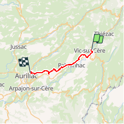
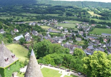
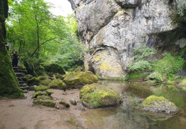
Etape 12 de la via Arverna, chemin de Saint Jacques de Compostelle entre Clermont-Ferrand et Cahors. Cette étape longe la vallée de la Cère pour rejoindre Aurillac, chef-lieu et porte d’entrée vers les monts et le plomb du Cantal. Au cours de ce chemin, passage par plusieurs villages et curiosités (château de Polminhac). Ensuite, transition via les plaines permettant une découverte progressive d’Aurillac et de son agglomération. Retrouvez l'étape n° 12 sur le site de la «Via Arverna - chemin Saint-Jacques-de-Compostelle» ainsi qu'ICI sur le site de la « Via Arverna ».

Hoogteprofiel

Foto's

Plaatsbepaling

Land:
France
Regio :
Auvergne-Rhône-Alpes
Departement/Provincie :
Cantal
Gemeente :
Vic-sur-Cère
Locatie:
Unknown
Vertrek:(Dec)
Vertrek:(UTM)
470743 ; 4980941 (31T) N.

Wandeltochten in de omgeving

Tocht Stappen Thiézac - La Porte du Lion - Thiézac - Photo
Stappen
tracegps

Stappen

Medium
(2)
Thiézac, Auvergne-Rhône-Alpes, Cantal, France
6,6 km | 10,5 km-effort
3h 0min
Ja
Tocht Stappen Polminhac - Polminhac - Autour du donjon - Photo
Stappen
tracegps

Stappen

Gemakkelijk
(1)
Polminhac, Auvergne-Rhône-Alpes, Cantal, France
5,2 km | 8,6 km-effort
2h 0min
Ja
Tocht Stappen Thiézac - La porte du Lion - Thiézac - Photo
Stappen
tracegps

Stappen

Medium
(2)
Thiézac, Auvergne-Rhône-Alpes, Cantal, France
7,6 km | 11,5 km-effort
3h 30min
Ja
Tocht Stappen Pailherols - Pailherols chapelle du Cantal  - Photo
Stappen
GUIDE
antignacs

Stappen

Medium
Pailherols, Auvergne-Rhône-Alpes, Cantal, France
21 km | 29 km-effort
5h 29min
Ja
Tocht Stappen Vic-sur-Cère - Pas de Cère- cascade de Gourdole - Photo
Stappen
crocau

Stappen

Heel gemakkelijk
Vic-sur-Cère, Auvergne-Rhône-Alpes, Cantal, France
4,7 km | 6,6 km-effort
2h 0min
Ja
Tocht Stappen Thiézac - Puy de la poche  - Photo
Stappen
nadd73

Stappen

Gemakkelijk
Thiézac, Auvergne-Rhône-Alpes, Cantal, France
13,1 km | 23 km-effort
3h 14min
Ja
Tocht Stappen Thiézac - Les Gorges du Pas de Cère - Photo
Stappen
VacheKiri67

Stappen

Gemakkelijk
Thiézac, Auvergne-Rhône-Alpes, Cantal, France
4,8 km | 6,8 km-effort
2h 21min
Ja
Tocht Stappen Lascelle - Arbre de quenouille, rocher saint curial, col de berganti - Photo
Stappen
impradine

Stappen

Gemakkelijk
Lascelle, Auvergne-Rhône-Alpes, Cantal, France
12,8 km | 19 km-effort
3h 37min
Ja
Tocht Stappen Pailherols - rando sentier des  gentianes - Photo
Stappen
Sandrine 15

Stappen

Medium
Pailherols, Auvergne-Rhône-Alpes, Cantal, France
13,1 km | 17,7 km-effort
3h 20min
Ja


Sluiten
Mijn abonnementen