![](/images/other/stat-length.png)
![Tocht Mountainbike Fontaine-les-Coteaux - VTT autour de Fontaine-les-Coteaux - Photo](https://media.geolcdn.com/t/1900/400/ext.pjpeg?maxdim=2&url=https%3A%2F%2Fservices.sitytrail.com%2FGeolivesWS%2FDownloadMedia.ashx%3FTrailID%3D172891%26Media%3D14350_5.jpg)
VTT autour de Fontaine-les-Coteaux
tracegps
Gebruiker
![Lengte](/images/other/stat-length.png)
Lengte
50 km
![Max. hoogte](https://static1.geolcdn.com/siteimages/upload/files/1508320355ic_sort_altitude_max_24dp.png)
Max. hoogte
158 m
![Positief hoogteverschil](https://static1.geolcdn.com/siteimages/upload/files/1508320355ic_sort_den_pos_24dp.png)
Positief hoogteverschil
696 m
![Km-Effort](/images/other/stat-length.png)
Km-Effort
59 km
![Min. hoogte](https://static1.geolcdn.com/siteimages/upload/files/1508320355ic_sort_altitude_min_24dp.png)
Min. hoogte
61 m
![Negatief hoogteverschil](https://static1.geolcdn.com/siteimages/upload/files/1508320355ic_sort_den_neg_24dp.png)
Negatief hoogteverschil
696 m
![Boucle](https://static1.geolcdn.com/siteimages/upload/files/16400158638029165_repeat_loop_refresh_sync_direction_icon.png)
Boucle
Ja
Datum van aanmaak :
2014-12-10 00:00:00.0
Laatste wijziging :
2014-12-10 00:00:00.0
![Mountainbike](https://static1.geolcdn.com/sitytour/trail-icons/202.png)
3h00
Moeilijkheid : Moeilijk
![Scan deze QR-code om de tocht te openen in de SityTrail-applicatie](https://capi.geolives.com/qq0zvz2zws4bq2lad0pu/sitytour/trails/172891/qr.png?size=200)
Gratisgps-wandelapplicatie
Over ons
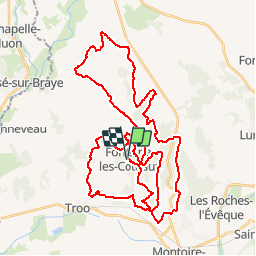
Tocht Mountainbike van 50 km beschikbaar op Centre-Val de Loire, Loir-et-Cher, Fontaine-les-Coteaux. Deze tocht wordt voorgesteld door tracegps.
Beschrijving
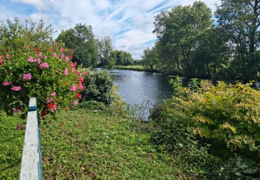
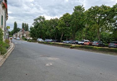
Départ du centre du village. Boucle de 50 km assez roulante comprenant, malgré tout, quelques bosses (750 m de dénivelé). Parcours difficile sur terrain gras.
Plaatsbepaling
Land:
France
Regio :
Centre-Val de Loire
Departement/Provincie :
Loir-et-Cher
Gemeente :
Fontaine-les-Coteaux
Locatie:
Unknown
Vertrek:(Dec)
Vertrek:(UTM)
337277 ; 5296213 (31T) N.
Opmerkingen
Wandeltochten in de omgeving
![Tocht Stappen Fontaine-les-Coteaux - Fontaine-les-coteaux - Bois de Beauvoir - Photo](https://media.geolcdn.com/t/375/260/03eb29ee-58eb-4007-b788-88126facd998.jpg&format=jpg&maxdim=2)
![Stappen Stappen](https://static1.geolcdn.com/sitytour/trail-icons/101.png)
Fontaine-les-coteaux - Bois de Beauvoir
Stappen
Medium
Fontaine-les-Coteaux,
Centre-Val de Loire,
Loir-et-Cher,
France
![](/images/other/stat-length.png)
11,7 km | 14,8 km-effort
3h 22min
![](https://static1.geolcdn.com/siteimages/upload/files/16400158638029165_repeat_loop_refresh_sync_direction_icon.png)
Ja
![Tocht Stappen Fontaine-les-Coteaux - Fontaine-les-Coteaux - Bois de Beauvoir - Photo](https://media.geolcdn.com/t/375/260/f4df1028-c791-4d9e-a4ba-018405d7c959.jpg&format=jpg&maxdim=2)
![Stappen Stappen](https://static1.geolcdn.com/sitytour/trail-icons/101.png)
Fontaine-les-Coteaux - Bois de Beauvoir
Stappen
Gemakkelijk
Fontaine-les-Coteaux,
Centre-Val de Loire,
Loir-et-Cher,
France
![](/images/other/stat-length.png)
9,1 km | 11,4 km-effort
2h 14min
![](https://static1.geolcdn.com/siteimages/upload/files/16400158638029165_repeat_loop_refresh_sync_direction_icon.png)
Ja
![Tocht Stappen Les Roches-l'Évêque - Les Roches-l'Evêque - Photo](https://media.geolcdn.com/t/375/260/dca20853-d794-4c8a-9c81-2319f41b2890.jpg&format=jpg&maxdim=2)
![Stappen Stappen](https://static1.geolcdn.com/sitytour/trail-icons/101.png)
Les Roches-l'Evêque
Stappen
Medium
Les Roches-l'Évêque,
Centre-Val de Loire,
Loir-et-Cher,
France
![](/images/other/stat-length.png)
8,8 km | 11,1 km-effort
2h 31min
![](https://static1.geolcdn.com/siteimages/upload/files/16400158638029165_repeat_loop_refresh_sync_direction_icon.png)
Ja
![Tocht Stappen Trôo - Trôo - Saugé - GR AR - 20.5km 340m 4h30 - 2018 05 20 - Photo](https://media.geolcdn.com/t/375/260/ext.jpg?maxdim=2&url=https%3A%2F%2Fstatic1.geolcdn.com%2Fsiteimages%2Fupload%2Ffiles%2F1553511878bg_sport_marche.png)
![Stappen Stappen](https://static1.geolcdn.com/sitytour/trail-icons/101.png)
Trôo - Saugé - GR AR - 20.5km 340m 4h30 - 2018 05 20
Stappen
Medium
Trôo,
Centre-Val de Loire,
Loir-et-Cher,
France
![](/images/other/stat-length.png)
20 km | 25 km-effort
4h 30min
![](https://static1.geolcdn.com/siteimages/upload/files/16400158638029165_repeat_loop_refresh_sync_direction_icon.png)
Ja
![Tocht Stappen Trôo - Trôo - 12.4km 280m 3h20 - 2017 05 28 - Photo](https://media.geolcdn.com/t/375/260/ext.jpg?maxdim=2&url=https%3A%2F%2Fstatic1.geolcdn.com%2Fsiteimages%2Fupload%2Ffiles%2F1553511878bg_sport_marche.png)
![Stappen Stappen](https://static1.geolcdn.com/sitytour/trail-icons/101.png)
Trôo - 12.4km 280m 3h20 - 2017 05 28
Stappen
Medium
Trôo,
Centre-Val de Loire,
Loir-et-Cher,
France
![](/images/other/stat-length.png)
12,4 km | 15,8 km-effort
3h 20min
![](https://static1.geolcdn.com/siteimages/upload/files/16400158638029165_repeat_loop_refresh_sync_direction_icon.png)
Ja
![Tocht Stappen Trôo - Sentier des troglodytes à Trôo - Photo](https://media.geolcdn.com/t/375/260/3c5c649d-692b-4680-8b9c-2f6808188217.jpg&format=jpg&maxdim=2)
![Stappen Stappen](https://static1.geolcdn.com/sitytour/trail-icons/101.png)
Sentier des troglodytes à Trôo
Stappen
Moeilijk
Trôo,
Centre-Val de Loire,
Loir-et-Cher,
France
![](/images/other/stat-length.png)
2,6 km | 3,6 km-effort
1h 5min
![](https://static1.geolcdn.com/siteimages/upload/files/16400158638029165_repeat_loop_refresh_sync_direction_icon.png)
Ja
![Tocht Te voet Trôo - troo - Photo](https://media.geolcdn.com/t/375/260/ext.jpg?maxdim=2&url=https%3A%2F%2Fstatic1.geolcdn.com%2Fsiteimages%2Fupload%2Ffiles%2F1545311037marcheuse_200dpi.jpg)
![Te voet Te voet](https://static1.geolcdn.com/sitytour/trail-icons/100.png)
troo
Te voet
Heel gemakkelijk
Trôo,
Centre-Val de Loire,
Loir-et-Cher,
France
![](/images/other/stat-length.png)
16 km | 19 km-effort
Onbekend
![](https://static1.geolcdn.com/siteimages/upload/files/16400158638029165_repeat_loop_refresh_sync_direction_icon.png)
Ja
![Tocht Stappen Montoire-sur-le-Loir - Montoire 1.10.2023 - Photo](https://media.geolcdn.com/t/375/260/ext.jpg?maxdim=2&url=https%3A%2F%2Fstatic1.geolcdn.com%2Fsiteimages%2Fupload%2Ffiles%2F1553511878bg_sport_marche.png)
![Stappen Stappen](https://static1.geolcdn.com/sitytour/trail-icons/101.png)
Montoire 1.10.2023
Stappen
Medium
Montoire-sur-le-Loir,
Centre-Val de Loire,
Loir-et-Cher,
France
![](/images/other/stat-length.png)
34 km | 40 km-effort
5h 28min
![](https://static1.geolcdn.com/siteimages/upload/files/16400158638029165_repeat_loop_refresh_sync_direction_icon.png)
Ja
![Tocht Stappen Trôo - Trôo 23-05-2022 - Photo](https://media.geolcdn.com/t/375/260/ext.jpg?maxdim=2&url=https%3A%2F%2Fstatic1.geolcdn.com%2Fsiteimages%2Fupload%2Ffiles%2F1553511878bg_sport_marche.png)
![Stappen Stappen](https://static1.geolcdn.com/sitytour/trail-icons/101.png)
Trôo 23-05-2022
Stappen
Gemakkelijk
(1)
Trôo,
Centre-Val de Loire,
Loir-et-Cher,
France
![](/images/other/stat-length.png)
6,4 km | 8,4 km-effort
1h 53min
![](https://static1.geolcdn.com/siteimages/upload/files/16400158638029165_repeat_loop_refresh_sync_direction_icon.png)
Ja