![](/images/other/stat-length.png)
![Tocht Mountainbike Katzenthal - Les hauteurs de Katzenthal - Photo](https://media.geolcdn.com/t/1900/400/ext.pjpeg?maxdim=2&url=https%3A%2F%2Fservices.sitytrail.com%2FGeolivesWS%2FDownloadMedia.ashx%3FTrailID%3D172879%26Media%3D14333_1.jpg)
Les hauteurs de Katzenthal
tracegps
Gebruiker
![Lengte](/images/other/stat-length.png)
Lengte
4,5 km
![Max. hoogte](https://static1.geolcdn.com/siteimages/upload/files/1508320355ic_sort_altitude_max_24dp.png)
Max. hoogte
444 m
![Positief hoogteverschil](https://static1.geolcdn.com/siteimages/upload/files/1508320355ic_sort_den_pos_24dp.png)
Positief hoogteverschil
163 m
![Km-Effort](/images/other/stat-length.png)
Km-Effort
6,7 km
![Min. hoogte](https://static1.geolcdn.com/siteimages/upload/files/1508320355ic_sort_altitude_min_24dp.png)
Min. hoogte
272 m
![Negatief hoogteverschil](https://static1.geolcdn.com/siteimages/upload/files/1508320355ic_sort_den_neg_24dp.png)
Negatief hoogteverschil
166 m
![Boucle](https://static1.geolcdn.com/siteimages/upload/files/16400158638029165_repeat_loop_refresh_sync_direction_icon.png)
Boucle
Ja
Datum van aanmaak :
2014-12-10 00:00:00.0
Laatste wijziging :
2014-12-10 00:00:00.0
![Mountainbike](https://static1.geolcdn.com/sitytour/trail-icons/202.png)
1h00
Moeilijkheid : Gemakkelijk
![Scan deze QR-code om de tocht te openen in de SityTrail-applicatie](https://capi.geolives.com/qq0zvz2zws4bq2lad0pu/sitytour/trails/172879/qr.png?size=200)
Gratisgps-wandelapplicatie
Over ons
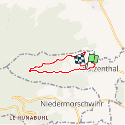
Tocht Mountainbike van 4,5 km beschikbaar op Grand Est, Haut-Rhin, Katzenthal. Deze tocht wordt voorgesteld door tracegps.
Beschrijving
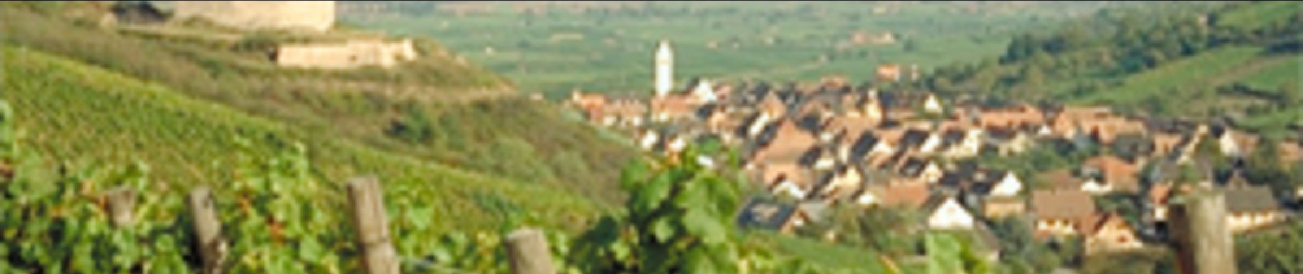
Une balade courte à faire en famille. De jolis points de vue sur la Plaine d'Alsace et son Vignoble. Possibilité de visiter le château du Wineck le dimanche après midi.
Plaatsbepaling
Land:
France
Regio :
Grand Est
Departement/Provincie :
Haut-Rhin
Gemeente :
Katzenthal
Locatie:
Unknown
Vertrek:(Dec)
Vertrek:(UTM)
371944 ; 5329721 (32U) N.
Opmerkingen
Wandeltochten in de omgeving
![Tocht Stappen Ammerschwihr - D'Ammerschwihr aux Trois Epis - Photo](https://media.geolcdn.com/t/375/260/ext.jpg?maxdim=2&url=https%3A%2F%2Fservices.sitytrail.com%2FGeolivesWS%2FDownloadMedia.ashx%3FTrailID%3D404804%26Media%3Dfix__20150406154748.jpg)
![Stappen Stappen](https://static1.geolcdn.com/sitytour/trail-icons/101.png)
D'Ammerschwihr aux Trois Epis
Stappen
Moeilijk
(1)
Ammerschwihr,
Grand Est,
Haut-Rhin,
France
![](/images/other/stat-length.png)
17,1 km | 25 km-effort
5h 35min
![](https://static1.geolcdn.com/siteimages/upload/files/16400158638029165_repeat_loop_refresh_sync_direction_icon.png)
Ja
![Tocht Stappen Ammerschwihr - Trois Épis le rocher du corbeau - Photo](https://media.geolcdn.com/t/375/260/ext.jpg?maxdim=2&url=https%3A%2F%2Fmedia.geolcdn.com%2Ff%2Fdbdb5766-f574-4a80-9cd8-371c84f0061c.jpg)
![Stappen Stappen](https://static1.geolcdn.com/sitytour/trail-icons/101.png)
Trois Épis le rocher du corbeau
Stappen
Gemakkelijk
(2)
Ammerschwihr,
Grand Est,
Haut-Rhin,
France
![](/images/other/stat-length.png)
4,4 km | 5,7 km-effort
59min
![](https://static1.geolcdn.com/siteimages/upload/files/16400158638029165_repeat_loop_refresh_sync_direction_icon.png)
Ja
![Tocht Stappen Kaysersberg-Vignoble - 2021-05-30 Marche Kaysersberg Ursprung St Alexis - Photo](https://media.geolcdn.com/t/375/260/ext.jpg?maxdim=2&url=https%3A%2F%2Fmedia.geolcdn.com%2Ff%2F4ae16611-5255-49df-be17-2a5aa0e78321.jpg)
![Stappen Stappen](https://static1.geolcdn.com/sitytour/trail-icons/101.png)
2021-05-30 Marche Kaysersberg Ursprung St Alexis
Stappen
Zeer moeilijk
Kaysersberg-Vignoble,
Grand Est,
Haut-Rhin,
France
![](/images/other/stat-length.png)
17,1 km | 26 km-effort
4h 46min
![](https://static1.geolcdn.com/siteimages/upload/files/16400158638029165_repeat_loop_refresh_sync_direction_icon.png)
Ja
![Tocht Paardrijden Kaysersberg-Vignoble - 2019-10-26 CDTE67 Tournage Video Promotion TE - Photo](https://media.geolcdn.com/t/375/260/ext.jpg?maxdim=2&url=https%3A%2F%2Fmedia.geolcdn.com%2Ff%2Fd78bcf89-6739-4bcc-854f-0c743f5412b8.jpg)
![Paardrijden Paardrijden](https://static1.geolcdn.com/sitytour/trail-icons/301.png)
2019-10-26 CDTE67 Tournage Video Promotion TE
Paardrijden
Gemakkelijk
Kaysersberg-Vignoble,
Grand Est,
Haut-Rhin,
France
![](/images/other/stat-length.png)
24 km | 29 km-effort
24min
![](https://static1.geolcdn.com/siteimages/upload/files/16400158638029165_repeat_loop_refresh_sync_direction_icon.png)
Neen
![Tocht Paardrijden Kaysersberg-Vignoble - 000004 - Photo](https://media.geolcdn.com/t/375/260/ext.jpg?maxdim=2&url=https%3A%2F%2Fmedia.geolcdn.com%2Ff%2Ffc80041c-b401-476e-a019-02f21cb51a95.jpg)
![Paardrijden Paardrijden](https://static1.geolcdn.com/sitytour/trail-icons/301.png)
000004
Paardrijden
Zeer moeilijk
Kaysersberg-Vignoble,
Grand Est,
Haut-Rhin,
France
![](/images/other/stat-length.png)
32 km | 45 km-effort
5h 55min
![](https://static1.geolcdn.com/siteimages/upload/files/16400158638029165_repeat_loop_refresh_sync_direction_icon.png)
Ja
![Tocht Stappen Kaysersberg-Vignoble - Le tour de Kysersberg - Photo](https://media.geolcdn.com/t/375/260/ext.jpg?maxdim=2&url=https%3A%2F%2Fservices.sitytrail.com%2FGeolivesWS%2FDownloadMedia.ashx%3FTrailID%3D482177%26Media%3D9aff239b-2fb3-4dd0-a536-a4dc7a8f2dee.jpg)
![Stappen Stappen](https://static1.geolcdn.com/sitytour/trail-icons/101.png)
Le tour de Kysersberg
Stappen
Medium
(1)
Kaysersberg-Vignoble,
Grand Est,
Haut-Rhin,
France
![](/images/other/stat-length.png)
7,9 km | 11,7 km-effort
2h 34min
![](https://static1.geolcdn.com/siteimages/upload/files/16400158638029165_repeat_loop_refresh_sync_direction_icon.png)
Ja
![Tocht Mountainbike Wintzenheim - Wintzenheim - Le Stauffen - Col de Marbach - Soultzbach - Photo](https://media.geolcdn.com/t/375/260/ext.jpg?maxdim=2&url=https%3A%2F%2Fstatic1.geolcdn.com%2Fsiteimages%2Fupload%2Ffiles%2F1524743154velo.jpg)
![Mountainbike Mountainbike](https://static1.geolcdn.com/sitytour/trail-icons/202.png)
Wintzenheim - Le Stauffen - Col de Marbach - Soultzbach
Mountainbike
Medium
(1)
Wintzenheim,
Grand Est,
Haut-Rhin,
France
![](/images/other/stat-length.png)
23 km | 31 km-effort
2h 4min
![](https://static1.geolcdn.com/siteimages/upload/files/16400158638029165_repeat_loop_refresh_sync_direction_icon.png)
Ja
![Tocht Stappen Wintzenheim - Château de Pflixbourg depuis Saint Gilles - Photo](https://media.geolcdn.com/t/375/260/ext.jpg?maxdim=2&url=https%3A%2F%2Fstatic1.geolcdn.com%2Fsiteimages%2Fupload%2Ffiles%2F1553511878bg_sport_marche.png)
![Stappen Stappen](https://static1.geolcdn.com/sitytour/trail-icons/101.png)
Château de Pflixbourg depuis Saint Gilles
Stappen
Gemakkelijk
(1)
Wintzenheim,
Grand Est,
Haut-Rhin,
France
![](/images/other/stat-length.png)
3,7 km | 6,2 km-effort
1h 21min
![](https://static1.geolcdn.com/siteimages/upload/files/16400158638029165_repeat_loop_refresh_sync_direction_icon.png)
Ja
![Tocht Stappen Katzenthal - Katzenthal - Photo](https://media.geolcdn.com/t/375/260/ext.jpg?maxdim=2&url=https%3A%2F%2Fmedia.geolcdn.com%2Ff%2Fcfd157b8-7003-4f6d-91be-da1f172f30db.jpg)
![Stappen Stappen](https://static1.geolcdn.com/sitytour/trail-icons/101.png)
Katzenthal
Stappen
Moeilijk
Katzenthal,
Grand Est,
Haut-Rhin,
France
![](/images/other/stat-length.png)
16,4 km | 25 km-effort
5h 40min
![](https://static1.geolcdn.com/siteimages/upload/files/16400158638029165_repeat_loop_refresh_sync_direction_icon.png)
Ja