![](/images/other/stat-length.png)
![Tocht Stappen Roche-Saint-Secret-Béconne - Tour du Pays de Dieulefit - Fontlargias à Teyssières - Photo](https://media.geolcdn.com/t/1900/400/ext.pjpeg?maxdim=2&url=https%3A%2F%2Fservices.sitytrail.com%2FGeolivesWS%2FDownloadMedia.ashx%3FTrailID%3D172797%26Media%3D14227_4.jpg)
Tour du Pays de Dieulefit - Fontlargias à Teyssières
tracegps
Gebruiker
![Lengte](/images/other/stat-length.png)
![Max. hoogte](https://static1.geolcdn.com/siteimages/upload/files/1508320355ic_sort_altitude_max_24dp.png)
![Positief hoogteverschil](https://static1.geolcdn.com/siteimages/upload/files/1508320355ic_sort_den_pos_24dp.png)
![Km-Effort](/images/other/stat-length.png)
![Min. hoogte](https://static1.geolcdn.com/siteimages/upload/files/1508320355ic_sort_altitude_min_24dp.png)
![Negatief hoogteverschil](https://static1.geolcdn.com/siteimages/upload/files/1508320355ic_sort_den_neg_24dp.png)
![Boucle](https://static1.geolcdn.com/siteimages/upload/files/16400158638029165_repeat_loop_refresh_sync_direction_icon.png)
![Stappen](https://static1.geolcdn.com/sitytour/trail-icons/101.png)
4h00
Moeilijkheid : Moeilijk
![Scan deze QR-code om de tocht te openen in de SityTrail-applicatie](https://capi.geolives.com/qq0zvz2zws4bq2lad0pu/sitytour/trails/172797/qr.png?size=200)
Gratisgps-wandelapplicatie
Over ons
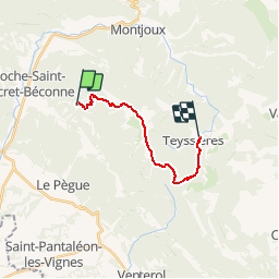
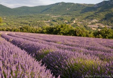
Tocht Stappen van 13,3 km beschikbaar op Auvergne-Rhône-Alpes, Drôme, Roche-Saint-Secret-Béconne. Deze tocht wordt voorgesteld door tracegps.
Beschrijving
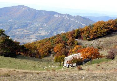
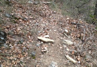
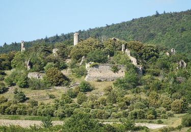
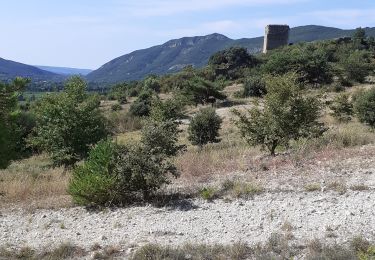
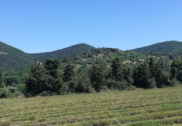
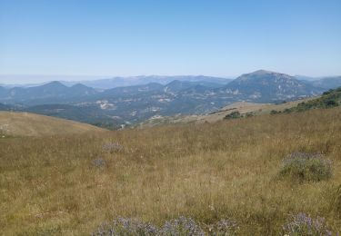
Quatrième étape: en route pour un parcours de long des crêtes de la Montagne de La Lance. Des falaises de La Roche Garaux (1340m) la vue s'étend sur le Pays de Dieulefit. Sous le couvert boisé on rejoins le Vieux Village de Teyssières (718m). Retrouvez le plan global du circuit sur le site de la Communauté de Communes du pays de Dieulefit.
Plaatsbepaling
Opmerkingen
Wandeltochten in de omgeving
![Tocht Stappen Montjoux - Le Devès - Montjoux - Photo](https://media.geolcdn.com/t/375/260/ext.jpg?maxdim=2&url=https%3A%2F%2Fservices.sitytrail.com%2FGeolivesWS%2FDownloadMedia.ashx%3FTrailID%3D172804%26Media%3D14234_5.jpg)
![Stappen Stappen](https://static1.geolcdn.com/sitytour/trail-icons/101.png)
Stappen
![](/images/other/stat-length.png)
![](https://static1.geolcdn.com/siteimages/upload/files/16400158638029165_repeat_loop_refresh_sync_direction_icon.png)
![Tocht Stappen Montjoux - 2022-12-16_08h52m12_tmpWriteApidae_48958_fr - Photo](https://media.geolcdn.com/t/375/260/cbc34adf-c509-4a94-9b7f-6317c0990136.jpg&format=jpg&maxdim=2)
![Stappen Stappen](https://static1.geolcdn.com/sitytour/trail-icons/101.png)
Stappen
![](/images/other/stat-length.png)
![](https://static1.geolcdn.com/siteimages/upload/files/16400158638029165_repeat_loop_refresh_sync_direction_icon.png)
![Tocht Stappen Roche-Saint-Secret-Béconne - 26montjoux - Photo](https://media.geolcdn.com/t/375/260/a6833288-f9f8-48b3-afa2-e10324484402.jpg&format=jpg&maxdim=2)
![Stappen Stappen](https://static1.geolcdn.com/sitytour/trail-icons/101.png)
Stappen
![](/images/other/stat-length.png)
![](https://static1.geolcdn.com/siteimages/upload/files/16400158638029165_repeat_loop_refresh_sync_direction_icon.png)
![Tocht Stappen Rousset-les-Vignes - Rousset- La Lance - Photo](https://media.geolcdn.com/t/375/260/84d3931f-2eee-4f55-959d-db8a6d419ca0.jpg&format=jpg&maxdim=2)
![Stappen Stappen](https://static1.geolcdn.com/sitytour/trail-icons/101.png)
Stappen
![](/images/other/stat-length.png)
![](https://static1.geolcdn.com/siteimages/upload/files/16400158638029165_repeat_loop_refresh_sync_direction_icon.png)
![Tocht Stappen Roche-Saint-Secret-Béconne - 2024-11-08_07h25m28_La_Roche_Saint_Secret_par_la_Tour_d_Alencon_et_les_Ruines_de_Beconne - Photo](https://media.geolcdn.com/t/375/260/03c83edb-ebec-4386-95bd-750d45047f97.jpg&format=jpg&maxdim=2)
![Stappen Stappen](https://static1.geolcdn.com/sitytour/trail-icons/101.png)
Stappen
![](/images/other/stat-length.png)
![](https://static1.geolcdn.com/siteimages/upload/files/16400158638029165_repeat_loop_refresh_sync_direction_icon.png)
![Tocht Stappen Roche-Saint-Secret-Béconne - Rachas par Roche Saint-Secret - Photo](https://media.geolcdn.com/t/375/260/363de164-439a-4b5a-97f1-30648b59a904.jpg&format=jpg&maxdim=2)
![Stappen Stappen](https://static1.geolcdn.com/sitytour/trail-icons/101.png)
Stappen
![](/images/other/stat-length.png)
![](https://static1.geolcdn.com/siteimages/upload/files/16400158638029165_repeat_loop_refresh_sync_direction_icon.png)
![Tocht Stappen Roche-Saint-Secret-Béconne - Béconne Roche - Photo](https://media.geolcdn.com/t/375/260/1e16a547-eb60-47e1-afef-278a2ce787cc.jpg&format=jpg&maxdim=2)
![Stappen Stappen](https://static1.geolcdn.com/sitytour/trail-icons/101.png)
Stappen
![](/images/other/stat-length.png)
![](https://static1.geolcdn.com/siteimages/upload/files/16400158638029165_repeat_loop_refresh_sync_direction_icon.png)
![Tocht Stappen Venterol - le cougoir - Photo](https://media.geolcdn.com/t/375/260/37fd75d5-0091-4964-9bad-4ec775b5e571.jpg&format=jpg&maxdim=2)
![Stappen Stappen](https://static1.geolcdn.com/sitytour/trail-icons/101.png)
Stappen
![](/images/other/stat-length.png)
![](https://static1.geolcdn.com/siteimages/upload/files/16400158638029165_repeat_loop_refresh_sync_direction_icon.png)
![Tocht Stappen Roche-Saint-Secret-Béconne - Roche-Saint-Secret-Beconne : Serre des Vignes. 13km. - Photo](https://media.geolcdn.com/t/375/260/a8478607-a359-49d8-b1f3-5bc502d84c85.jpg&format=jpg&maxdim=2)
![Stappen Stappen](https://static1.geolcdn.com/sitytour/trail-icons/101.png)
Stappen
![](/images/other/stat-length.png)
![](https://static1.geolcdn.com/siteimages/upload/files/16400158638029165_repeat_loop_refresh_sync_direction_icon.png)