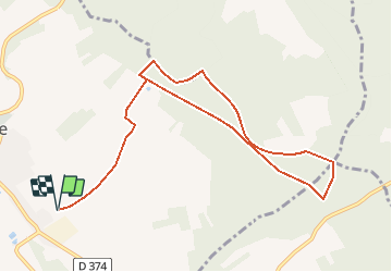
![](/images/other/stat-length.png)
![Tocht Stappen Aix-Villemaur-Pâlis - La Vove - Aix en Othe - Photo](https://media.geolcdn.com/t/1900/400/ext.pjpeg?maxdim=2&url=https%3A%2F%2Fservices.sitytrail.com%2FGeolivesWS%2FDownloadMedia.ashx%3FTrailID%3D172786%26Media%3D14215_4.jpg)
La Vove - Aix en Othe
tracegps
Gebruiker
![Lengte](/images/other/stat-length.png)
![Max. hoogte](https://static1.geolcdn.com/siteimages/upload/files/1508320355ic_sort_altitude_max_24dp.png)
![Positief hoogteverschil](https://static1.geolcdn.com/siteimages/upload/files/1508320355ic_sort_den_pos_24dp.png)
![Km-Effort](/images/other/stat-length.png)
![Min. hoogte](https://static1.geolcdn.com/siteimages/upload/files/1508320355ic_sort_altitude_min_24dp.png)
![Negatief hoogteverschil](https://static1.geolcdn.com/siteimages/upload/files/1508320355ic_sort_den_neg_24dp.png)
![Boucle](https://static1.geolcdn.com/siteimages/upload/files/16400158638029165_repeat_loop_refresh_sync_direction_icon.png)
![Stappen](https://static1.geolcdn.com/sitytour/trail-icons/101.png)
2h30
Moeilijkheid : Medium
![Scan deze QR-code om de tocht te openen in de SityTrail-applicatie](https://capi.geolives.com/qq0zvz2zws4bq2lad0pu/sitytour/trails/172786/qr.png?size=200)
Gratisgps-wandelapplicatie
Over ons
Tocht Stappen van 10,2 km beschikbaar op Grand Est, Aube, Aix-Villemaur-Pâlis. Deze tocht wordt voorgesteld door tracegps.
Beschrijving
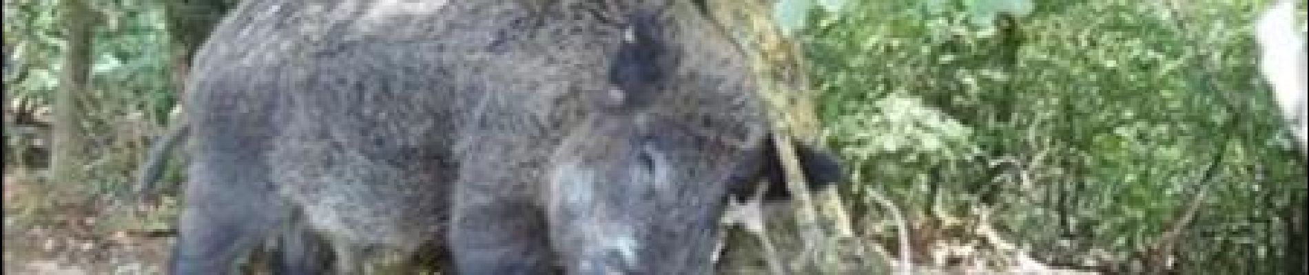
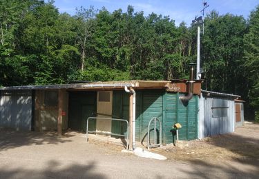
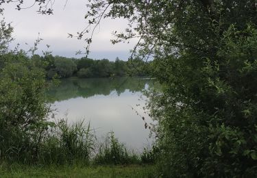
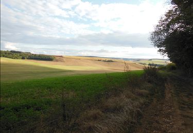
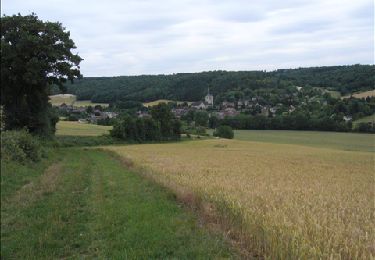
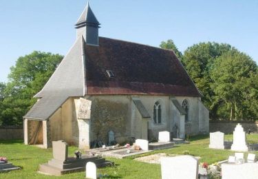
Départ/Arrivée : Lieu-dit « La Vove » (juste au sud d’Aix en Othe (10160)). Dans la première partie de la balade, on suit les traces du GR 2 «Pays de Saint Jacques de Compostelle ». On suit tout d’abord un long chemin qui passe devant la Ferme du Mont Saint Benoit. Juste avant d’arriver à la ferme, sur la droite (coté est du chemin), on voit un sous-bois clôturé d’un grillage, il s’agit apparemment d’une petite réserve de Sangliers. Nous avons d’ailleurs rencontré un sanglier qui visiblement n’était pas sauvage du tout: il se frottait fièrement devant nous contre un arbre tout en nous regardant… visiblement il aurait apprécié un bon (gros) sandwich au jambon. A la ferme, sur la gauche (coté sud du chemin), il y a des oies qui cohabitent avec quelques moutons, puis juste après la ferme, une sorte de grand verger (en tout cas un lieu récemment très arboré) qui avec de nombreux moutons de tous âges, dont certains étaient vraiment tout jeunes. Arrivé au Bois de La Brosse, le tronçon de GR emprunté est très agréable, avec des arbres variés (chênes, charmes, bouleaux… et aussi quelques résineux). Si pour le retour nous avons emprunté un chemin forestier un peu trop «monotone» à notre goût, nous avions pu remarquer que les chemins (contrairement à beaucoup d’endroits) sont très entretenus, ce qui offre de multiples variantes possibles pour revenir au point de départ de notre balade.
Plaatsbepaling
Opmerkingen
Wandeltochten in de omgeving
![Tocht Stappen Saint-Mards-en-Othe - De place en place - Saint Mards en Othe - Photo](https://media.geolcdn.com/t/375/260/ext.jpg?maxdim=2&url=https%3A%2F%2Fservices.sitytrail.com%2FGeolivesWS%2FDownloadMedia.ashx%3FTrailID%3D111322%26Media%3D6998_5.jpg)
![Stappen Stappen](https://static1.geolcdn.com/sitytour/trail-icons/101.png)
Stappen
![](/images/other/stat-length.png)
![](https://static1.geolcdn.com/siteimages/upload/files/16400158638029165_repeat_loop_refresh_sync_direction_icon.png)
![Tocht Stappen Saint-Mards-en-Othe - Saint-Mards en Othe 240609 - Photo](https://media.geolcdn.com/t/375/260/ddc9529f-8dc4-4780-8419-57effb1d731b.jpg&format=jpg&maxdim=2)
![Stappen Stappen](https://static1.geolcdn.com/sitytour/trail-icons/101.png)
Stappen
![](/images/other/stat-length.png)
![](https://static1.geolcdn.com/siteimages/upload/files/16400158638029165_repeat_loop_refresh_sync_direction_icon.png)
![Tocht Te voet Aix-Villemaur-Pâlis - Aix en Othe-Vaujurennes - Photo](https://media.geolcdn.com/t/375/260/ext.jpg?maxdim=2&url=https%3A%2F%2Fstatic1.geolcdn.com%2Fsiteimages%2Fupload%2Ffiles%2F1545311037marcheuse_200dpi.jpg)
![Te voet Te voet](https://static1.geolcdn.com/sitytour/trail-icons/100.png)
Te voet
![](/images/other/stat-length.png)
![](https://static1.geolcdn.com/siteimages/upload/files/16400158638029165_repeat_loop_refresh_sync_direction_icon.png)
![Tocht Stappen Aix-Villemaur-Pâlis - Bois des Brosses - Photo](https://media.geolcdn.com/t/375/260/8b3bc913-10c0-4ba8-9985-434accbe669e.jpg&format=jpg&maxdim=2)
![Stappen Stappen](https://static1.geolcdn.com/sitytour/trail-icons/101.png)
Stappen
![](/images/other/stat-length.png)
![](https://static1.geolcdn.com/siteimages/upload/files/16400158638029165_repeat_loop_refresh_sync_direction_icon.png)
![Tocht Stappen Aix-Villemaur-Pâlis - Villemaur sur Vanne - Photo](https://media.geolcdn.com/t/375/260/077714cb-b931-402d-a46a-1b9837d21fba.jpg&format=jpg&maxdim=2)
![Stappen Stappen](https://static1.geolcdn.com/sitytour/trail-icons/101.png)
Stappen
![](/images/other/stat-length.png)
![](https://static1.geolcdn.com/siteimages/upload/files/16400158638029165_repeat_loop_refresh_sync_direction_icon.png)
![Tocht Stappen Aix-Villemaur-Pâlis - La Vove - Bois de la Brosse - Photo](https://media.geolcdn.com/t/375/260/ext.jpg?maxdim=2&url=https%3A%2F%2Fservices.sitytrail.com%2FGeolivesWS%2FDownloadMedia.ashx%3FTrailID%3D156019%26Media%3D3640a2a1-46ce-4143-b05f-39c0dd8ad6c4.JPG)
![Stappen Stappen](https://static1.geolcdn.com/sitytour/trail-icons/101.png)
Stappen
![](/images/other/stat-length.png)
![](https://static1.geolcdn.com/siteimages/upload/files/16400158638029165_repeat_loop_refresh_sync_direction_icon.png)
![Tocht Stappen Paisy-Cosdon - Vaujurennes - Bérulle (Boucle) 2011 - Photo](https://media.geolcdn.com/t/375/260/ext.jpg?maxdim=2&url=https%3A%2F%2Fservices.sitytrail.com%2FGeolivesWS%2FDownloadMedia.ashx%3FTrailID%3D152737%26Media%3D61315afe-d38a-4173-bfb9-c391c7bdfadb.JPG)
![Stappen Stappen](https://static1.geolcdn.com/sitytour/trail-icons/101.png)
Stappen
![](/images/other/stat-length.png)
![](https://static1.geolcdn.com/siteimages/upload/files/16400158638029165_repeat_loop_refresh_sync_direction_icon.png)
![Tocht Fiets Villemoiron-en-Othe - Circuit de Villemoiron en Othe - Photo](https://media.geolcdn.com/t/375/260/ext.jpg?maxdim=2&url=https%3A%2F%2Fservices.sitytrail.com%2FGeolivesWS%2FDownloadMedia.ashx%3FTrailID%3D112808%26Media%3D12482_5.jpg)
![Fiets Fiets](https://static1.geolcdn.com/sitytour/trail-icons/200.png)
Fiets
![](/images/other/stat-length.png)
![](https://static1.geolcdn.com/siteimages/upload/files/16400158638029165_repeat_loop_refresh_sync_direction_icon.png)
![Tocht Fiets Saint-Mards-en-Othe - Circuit de Saint-Mards-en-Othe - Photo](https://media.geolcdn.com/t/375/260/ext.jpg?maxdim=2&url=https%3A%2F%2Fservices.sitytrail.com%2FGeolivesWS%2FDownloadMedia.ashx%3FTrailID%3D112786%26Media%3D12393_4.jpg)
![Fiets Fiets](https://static1.geolcdn.com/sitytour/trail-icons/200.png)
Fiets
![](/images/other/stat-length.png)
![](https://static1.geolcdn.com/siteimages/upload/files/16400158638029165_repeat_loop_refresh_sync_direction_icon.png)
belle petite balade pouvant se faire en famille ( plus de 10 ans). effectivement, le retour est un peu monotone.