![](/images/other/stat-length.png)
![Tocht Mountainbike Coutances - Rando VTT à Coutance 2012 - Photo](https://media.geolcdn.com/t/1900/400/ext.pjpeg?maxdim=2&url=https%3A%2F%2Fservices.sitytrail.com%2FGeolivesWS%2FDownloadMedia.ashx%3FTrailID%3D172658%26Media%3D14030_1.jpg)
Rando VTT à Coutance 2012
tracegps
Gebruiker
![Lengte](/images/other/stat-length.png)
Lengte
68 km
![Max. hoogte](https://static1.geolcdn.com/siteimages/upload/files/1508320355ic_sort_altitude_max_24dp.png)
Max. hoogte
166 m
![Positief hoogteverschil](https://static1.geolcdn.com/siteimages/upload/files/1508320355ic_sort_den_pos_24dp.png)
Positief hoogteverschil
943 m
![Km-Effort](/images/other/stat-length.png)
Km-Effort
80 km
![Min. hoogte](https://static1.geolcdn.com/siteimages/upload/files/1508320355ic_sort_altitude_min_24dp.png)
Min. hoogte
39 m
![Negatief hoogteverschil](https://static1.geolcdn.com/siteimages/upload/files/1508320355ic_sort_den_neg_24dp.png)
Negatief hoogteverschil
941 m
![Boucle](https://static1.geolcdn.com/siteimages/upload/files/16400158638029165_repeat_loop_refresh_sync_direction_icon.png)
Boucle
Ja
Datum van aanmaak :
2014-12-10 00:00:00.0
Laatste wijziging :
2014-12-10 00:00:00.0
![Mountainbike](https://static1.geolcdn.com/sitytour/trail-icons/202.png)
5h00
Moeilijkheid : Moeilijk
![Scan deze QR-code om de tocht te openen in de SityTrail-applicatie](https://capi.geolives.com/qq0zvz2zws4bq2lad0pu/sitytour/trails/172658/qr.png?size=200)
Gratisgps-wandelapplicatie
Over ons
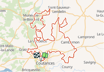
Tocht Mountainbike van 68 km beschikbaar op Normandië, Manche, Coutances. Deze tocht wordt voorgesteld door tracegps.
Beschrijving
Très bon circuit de 68km proposé par bekanabou. Le départ et l'arrivée se font du stade à Coutance. Grand parking pour se garer.
Plaatsbepaling
Land:
France
Regio :
Normandië
Departement/Provincie :
Manche
Gemeente :
Coutances
Locatie:
Unknown
Vertrek:(Dec)
Vertrek:(UTM)
612898 ; 5434186 (30U) N.
Opmerkingen
Wandeltochten in de omgeving
![Tocht Mountainbike Monthuchon - Autour de Feugères en VTT - Photo](https://media.geolcdn.com/t/375/260/ext.jpg?maxdim=2&url=https%3A%2F%2Fstatic1.geolcdn.com%2Fsiteimages%2Fupload%2Ffiles%2F1524743154velo.jpg)
![Mountainbike Mountainbike](https://static1.geolcdn.com/sitytour/trail-icons/202.png)
Autour de Feugères en VTT
Mountainbike
Moeilijk
(1)
Monthuchon,
Normandië,
Manche,
France
![](/images/other/stat-length.png)
62 km | 73 km-effort
4h 30min
![](https://static1.geolcdn.com/siteimages/upload/files/16400158638029165_repeat_loop_refresh_sync_direction_icon.png)
Ja
![Tocht Noords wandelen Orval-sur-Sienne - Monchaton - Photo](https://media.geolcdn.com/t/375/260/ext.jpg?maxdim=2&url=https%3A%2F%2Fstatic1.geolcdn.com%2Fsiteimages%2Fupload%2Ffiles%2F1545311037marcheuse_200dpi.jpg)
![Noords wandelen Noords wandelen](https://static1.geolcdn.com/sitytour/trail-icons/102.png)
Monchaton
Noords wandelen
Gemakkelijk
(1)
Orval-sur-Sienne,
Normandië,
Manche,
France
![](/images/other/stat-length.png)
11,2 km | 12,6 km-effort
2h 18min
![](https://static1.geolcdn.com/siteimages/upload/files/16400158638029165_repeat_loop_refresh_sync_direction_icon.png)
Ja
![Tocht Mountainbike Coutances - 1 pas, 2 pas pour Anaïs - Coutances - Photo](https://media.geolcdn.com/t/375/260/ext.jpg?maxdim=2&url=https%3A%2F%2Fservices.sitytrail.com%2FGeolivesWS%2FDownloadMedia.ashx%3FTrailID%3D318038%26Media%3D17505_6.jpg)
![Mountainbike Mountainbike](https://static1.geolcdn.com/sitytour/trail-icons/202.png)
1 pas, 2 pas pour Anaïs - Coutances
Mountainbike
Moeilijk
Coutances,
Normandië,
Manche,
France
![](/images/other/stat-length.png)
39 km | 47 km-effort
2h 45min
![](https://static1.geolcdn.com/siteimages/upload/files/16400158638029165_repeat_loop_refresh_sync_direction_icon.png)
Ja
![Tocht Stappen Coutances - Coutances - Photo](https://media.geolcdn.com/t/375/260/0b2e5541-0398-4c84-9ff0-41068c2ad6a0.jpg&format=jpg&maxdim=2)
![Stappen Stappen](https://static1.geolcdn.com/sitytour/trail-icons/101.png)
Coutances
Stappen
Gemakkelijk
Coutances,
Normandië,
Manche,
France
![](/images/other/stat-length.png)
10,6 km | 13,1 km-effort
2h 3min
![](https://static1.geolcdn.com/siteimages/upload/files/16400158638029165_repeat_loop_refresh_sync_direction_icon.png)
Ja
![Tocht Stappen Nicorps - Pédestre - Les trois vallées - Photo](https://media.geolcdn.com/t/375/260/229671c2-a2a1-4f0c-81cc-4048ae285e67.jpg&format=jpg&maxdim=2)
![Stappen Stappen](https://static1.geolcdn.com/sitytour/trail-icons/101.png)
Pédestre - Les trois vallées
Stappen
Medium
Nicorps,
Normandië,
Manche,
France
![](/images/other/stat-length.png)
12,4 km | 15,3 km-effort
3h 30min
![](https://static1.geolcdn.com/siteimages/upload/files/16400158638029165_repeat_loop_refresh_sync_direction_icon.png)
Ja
![Tocht Mountainbike Coutances - Rando des Petits Princes de Margot 2013 - Coutances - Photo](https://media.geolcdn.com/t/375/260/ext.jpg?maxdim=2&url=https%3A%2F%2Fservices.sitytrail.com%2FGeolivesWS%2FDownloadMedia.ashx%3FTrailID%3D317395%26Media%3D16614_1.jpg)
![Mountainbike Mountainbike](https://static1.geolcdn.com/sitytour/trail-icons/202.png)
Rando des Petits Princes de Margot 2013 - Coutances
Mountainbike
Moeilijk
Coutances,
Normandië,
Manche,
France
![](/images/other/stat-length.png)
42 km | 50 km-effort
2h 45min
![](https://static1.geolcdn.com/siteimages/upload/files/16400158638029165_repeat_loop_refresh_sync_direction_icon.png)
Ja
![Tocht Stappen Bricqueville-la-Blouette - Montchaton 25 juillet 2022 - Photo](https://media.geolcdn.com/t/375/260/ext.jpg?maxdim=2&url=https%3A%2F%2Fstatic1.geolcdn.com%2Fsiteimages%2Fupload%2Ffiles%2F1553511878bg_sport_marche.png)
![Stappen Stappen](https://static1.geolcdn.com/sitytour/trail-icons/101.png)
Montchaton 25 juillet 2022
Stappen
Medium
Bricqueville-la-Blouette,
Normandië,
Manche,
France
![](/images/other/stat-length.png)
7,7 km | 9 km-effort
1h 40min
![](https://static1.geolcdn.com/siteimages/upload/files/16400158638029165_repeat_loop_refresh_sync_direction_icon.png)
Neen
![Tocht Elektrische fiets Nicorps - boucle Nicorps - Le Pont de la Roque - Photo](https://media.geolcdn.com/t/375/260/ext.jpg?maxdim=2&url=https%3A%2F%2Fstatic1.geolcdn.com%2Fsiteimages%2Fupload%2Ffiles%2F1524743154velo.jpg)
![Elektrische fiets Elektrische fiets](https://static1.geolcdn.com/sitytour/trail-icons/205.png)
boucle Nicorps - Le Pont de la Roque
Elektrische fiets
Medium
Nicorps,
Normandië,
Manche,
France
![](/images/other/stat-length.png)
15,9 km | 18,2 km-effort
1h 32min
![](https://static1.geolcdn.com/siteimages/upload/files/16400158638029165_repeat_loop_refresh_sync_direction_icon.png)
Ja
![Tocht Andere activiteiten Courcy - Basse Normandie - Ligne 417 - Coutances - Sottevast - Photo](https://media.geolcdn.com/t/375/260/ext.jpg?maxdim=2&url=https%3A%2F%2Fstatic1.geolcdn.com%2Fsiteimages%2Fupload%2Ffiles%2F1545311037marcheuse_200dpi.jpg)
![Andere activiteiten Andere activiteiten](https://static1.geolcdn.com/sitytour/trail-icons/900.png)
Basse Normandie - Ligne 417 - Coutances - Sottevast
Andere activiteiten
Heel gemakkelijk
Courcy,
Normandië,
Manche,
France
![](/images/other/stat-length.png)
69 km | 75 km-effort
5min
![](https://static1.geolcdn.com/siteimages/upload/files/16400158638029165_repeat_loop_refresh_sync_direction_icon.png)
Neen