![](/images/other/stat-length.png)
![Tocht Stappen Labenne - Marais d'Orx et alentours - Photo](https://media.geolcdn.com/t/1900/400/ext.pjpeg?maxdim=2&url=https%3A%2F%2Fservices.sitytrail.com%2FGeolivesWS%2FDownloadMedia.ashx%3FTrailID%3D172398%26Media%3D13745_4.jpg)
Marais d'Orx et alentours
tracegps
Gebruiker
![Lengte](/images/other/stat-length.png)
Lengte
15,5 km
![Max. hoogte](https://static1.geolcdn.com/siteimages/upload/files/1508320355ic_sort_altitude_max_24dp.png)
Max. hoogte
56 m
![Positief hoogteverschil](https://static1.geolcdn.com/siteimages/upload/files/1508320355ic_sort_den_pos_24dp.png)
Positief hoogteverschil
158 m
![Km-Effort](/images/other/stat-length.png)
Km-Effort
17,6 km
![Min. hoogte](https://static1.geolcdn.com/siteimages/upload/files/1508320355ic_sort_altitude_min_24dp.png)
Min. hoogte
-2 m
![Negatief hoogteverschil](https://static1.geolcdn.com/siteimages/upload/files/1508320355ic_sort_den_neg_24dp.png)
Negatief hoogteverschil
150 m
![Boucle](https://static1.geolcdn.com/siteimages/upload/files/16400158638029165_repeat_loop_refresh_sync_direction_icon.png)
Boucle
Ja
Datum van aanmaak :
2014-12-10 00:00:00.0
Laatste wijziging :
2014-12-10 00:00:00.0
![Stappen](https://static1.geolcdn.com/sitytour/trail-icons/101.png)
3h30
Moeilijkheid : Medium
![Scan deze QR-code om de tocht te openen in de SityTrail-applicatie](https://capi.geolives.com/qq0zvz2zws4bq2lad0pu/sitytour/trails/172398/qr.png?size=200)
Gratisgps-wandelapplicatie
Over ons
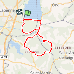
Tocht Stappen van 15,5 km beschikbaar op Nieuw-Aquitanië, Landes, Labenne. Deze tocht wordt voorgesteld door tracegps.
Beschrijving
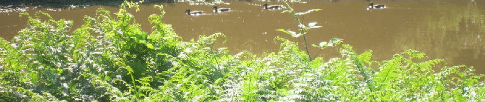
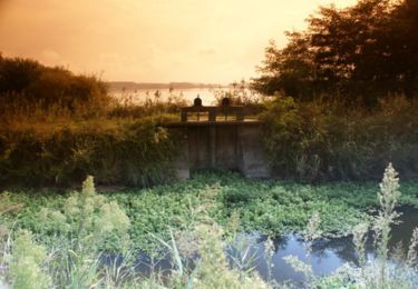
Une randonnée agréable notamment autour du marais (faune principalement). Un détour par les alentours avec un peu de route mais très sympathique. Si vous êtes photos, prenez un petit téléobjectif (70-200).
Plaatsbepaling
Land:
France
Regio :
Nieuw-Aquitanië
Departement/Provincie :
Landes
Gemeente :
Labenne
Locatie:
Unknown
Vertrek:(Dec)
Vertrek:(UTM)
628507 ; 4827510 (30T) N.
Opmerkingen
Wandeltochten in de omgeving
![Tocht Stappen Ondres - Pinède ondres - Photo](https://media.geolcdn.com/t/375/260/ext.jpg?maxdim=2&url=https%3A%2F%2Fstatic1.geolcdn.com%2Fsiteimages%2Fupload%2Ffiles%2F1553511878bg_sport_marche.png)
![Stappen Stappen](https://static1.geolcdn.com/sitytour/trail-icons/101.png)
Pinède ondres
Stappen
Gemakkelijk
(2)
Ondres,
Nieuw-Aquitanië,
Landes,
France
![](/images/other/stat-length.png)
9,1 km | 10,1 km-effort
2h 14min
![](https://static1.geolcdn.com/siteimages/upload/files/16400158638029165_repeat_loop_refresh_sync_direction_icon.png)
Ja
![Tocht Te voet Labenne - Pinède Ondres Jaune - Photo](https://media.geolcdn.com/t/375/260/b4b1e7a3-b617-4f71-bdd9-7457a045d6c9.jpeg&format=jpg&maxdim=2)
![Te voet Te voet](https://static1.geolcdn.com/sitytour/trail-icons/100.png)
Pinède Ondres Jaune
Te voet
Gemakkelijk
Labenne,
Nieuw-Aquitanië,
Landes,
France
![](/images/other/stat-length.png)
5,4 km | 6,1 km-effort
1h 22min
![](https://static1.geolcdn.com/siteimages/upload/files/16400158638029165_repeat_loop_refresh_sync_direction_icon.png)
Neen
![Tocht Mountainbike Bénesse-Maremne - Tour benesse - Photo](https://media.geolcdn.com/t/375/260/5c70f6a6-62fc-4eb2-a177-d0b0bc0632ff.jpg&format=jpg&maxdim=2)
![Mountainbike Mountainbike](https://static1.geolcdn.com/sitytour/trail-icons/202.png)
Tour benesse
Mountainbike
Gemakkelijk
Bénesse-Maremne,
Nieuw-Aquitanië,
Landes,
France
![](/images/other/stat-length.png)
26 km | 29 km-effort
2h 23min
![](https://static1.geolcdn.com/siteimages/upload/files/16400158638029165_repeat_loop_refresh_sync_direction_icon.png)
Ja
![Tocht Stappen Ondres - Ondres nord 5.1 - Photo](https://media.geolcdn.com/t/375/260/ext.jpg?maxdim=2&url=https%3A%2F%2Fstatic1.geolcdn.com%2Fsiteimages%2Fupload%2Ffiles%2F1553511878bg_sport_marche.png)
![Stappen Stappen](https://static1.geolcdn.com/sitytour/trail-icons/101.png)
Ondres nord 5.1
Stappen
Heel gemakkelijk
Ondres,
Nieuw-Aquitanië,
Landes,
France
![](/images/other/stat-length.png)
9,1 km | 9,8 km-effort
3h 10min
![](https://static1.geolcdn.com/siteimages/upload/files/16400158638029165_repeat_loop_refresh_sync_direction_icon.png)
Ja
![Tocht Fiets Ondres - Ondres Hossegor - Photo](https://media.geolcdn.com/t/375/260/ext.jpg?maxdim=2&url=https%3A%2F%2Fstatic1.geolcdn.com%2Fsiteimages%2Fupload%2Ffiles%2F1524743154velo.jpg)
![Fiets Fiets](https://static1.geolcdn.com/sitytour/trail-icons/200.png)
Ondres Hossegor
Fiets
Heel gemakkelijk
Ondres,
Nieuw-Aquitanië,
Landes,
France
![](/images/other/stat-length.png)
38 km | 42 km-effort
3h 21min
![](https://static1.geolcdn.com/siteimages/upload/files/16400158638029165_repeat_loop_refresh_sync_direction_icon.png)
Ja
![Tocht Stappen Ondres - Ondres 1.2 - Photo](https://media.geolcdn.com/t/375/260/ext.jpg?maxdim=2&url=https%3A%2F%2Fstatic1.geolcdn.com%2Fsiteimages%2Fupload%2Ffiles%2F1553511878bg_sport_marche.png)
![Stappen Stappen](https://static1.geolcdn.com/sitytour/trail-icons/101.png)
Ondres 1.2
Stappen
Heel gemakkelijk
Ondres,
Nieuw-Aquitanië,
Landes,
France
![](/images/other/stat-length.png)
8,8 km | 9,7 km-effort
2h 30min
![](https://static1.geolcdn.com/siteimages/upload/files/16400158638029165_repeat_loop_refresh_sync_direction_icon.png)
Ja
![Tocht Stappen Ondres - Ondres Mardi 1 - Photo](https://media.geolcdn.com/t/375/260/ext.jpg?maxdim=2&url=https%3A%2F%2Fstatic1.geolcdn.com%2Fsiteimages%2Fupload%2Ffiles%2F1553511878bg_sport_marche.png)
![Stappen Stappen](https://static1.geolcdn.com/sitytour/trail-icons/101.png)
Ondres Mardi 1
Stappen
Heel gemakkelijk
Ondres,
Nieuw-Aquitanië,
Landes,
France
![](/images/other/stat-length.png)
7,9 km | 8,7 km-effort
2h 27min
![](https://static1.geolcdn.com/siteimages/upload/files/16400158638029165_repeat_loop_refresh_sync_direction_icon.png)
Ja
![Tocht Stappen Ondres - Ondres nord 5.1 - Photo](https://media.geolcdn.com/t/375/260/ext.jpg?maxdim=2&url=https%3A%2F%2Fstatic1.geolcdn.com%2Fsiteimages%2Fupload%2Ffiles%2F1553511878bg_sport_marche.png)
![Stappen Stappen](https://static1.geolcdn.com/sitytour/trail-icons/101.png)
Ondres nord 5.1
Stappen
Heel gemakkelijk
Ondres,
Nieuw-Aquitanië,
Landes,
France
![](/images/other/stat-length.png)
9,1 km | 9,8 km-effort
3h 10min
![](https://static1.geolcdn.com/siteimages/upload/files/16400158638029165_repeat_loop_refresh_sync_direction_icon.png)
Ja
![Tocht Stappen Saint-André-de-Seignanx - Autour du Marais d'Orx à Labenne - Photo](https://media.geolcdn.com/t/375/260/ext.jpg?maxdim=2&url=https%3A%2F%2Fservices.sitytrail.com%2FGeolivesWS%2FDownloadMedia.ashx%3FTrailID%3D110313%26Media%3D5741_1.jpg)
![Stappen Stappen](https://static1.geolcdn.com/sitytour/trail-icons/101.png)
Autour du Marais d'Orx à Labenne
Stappen
Medium
Saint-André-de-Seignanx,
Nieuw-Aquitanië,
Landes,
France
![](/images/other/stat-length.png)
5,5 km | 5,7 km-effort
1h 30min
![](https://static1.geolcdn.com/siteimages/upload/files/16400158638029165_repeat_loop_refresh_sync_direction_icon.png)
Ja