![](/images/other/stat-length.png)
![Tocht Mountainbike Sainte-Agathe-en-Donzy - A4 - VTT Montagnes du Matin - Sainte Agathe en Donzy - Photo](https://media.geolcdn.com/t/1900/400/ext.pjpeg?maxdim=2&url=https%3A%2F%2Fservices.sitytrail.com%2FGeolivesWS%2FDownloadMedia.ashx%3FTrailID%3D172322%26Media%3D13645_6.jpg)
A4 - VTT Montagnes du Matin - Sainte Agathe en Donzy
tracegps
Gebruiker
![Lengte](/images/other/stat-length.png)
![Max. hoogte](https://static1.geolcdn.com/siteimages/upload/files/1508320355ic_sort_altitude_max_24dp.png)
![Positief hoogteverschil](https://static1.geolcdn.com/siteimages/upload/files/1508320355ic_sort_den_pos_24dp.png)
![Km-Effort](/images/other/stat-length.png)
![Min. hoogte](https://static1.geolcdn.com/siteimages/upload/files/1508320355ic_sort_altitude_min_24dp.png)
![Negatief hoogteverschil](https://static1.geolcdn.com/siteimages/upload/files/1508320355ic_sort_den_neg_24dp.png)
![Boucle](https://static1.geolcdn.com/siteimages/upload/files/16400158638029165_repeat_loop_refresh_sync_direction_icon.png)
![Mountainbike](https://static1.geolcdn.com/sitytour/trail-icons/202.png)
2h00
Moeilijkheid : Moeilijk
![Scan deze QR-code om de tocht te openen in de SityTrail-applicatie](https://capi.geolives.com/qq0zvz2zws4bq2lad0pu/sitytour/trails/172322/qr.png?size=200)
Gratisgps-wandelapplicatie
Over ons
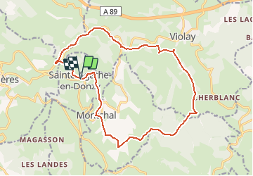
Tocht Mountainbike van 17,9 km beschikbaar op Auvergne-Rhône-Alpes, Loire, Sainte-Agathe-en-Donzy. Deze tocht wordt voorgesteld door tracegps.
Beschrijving
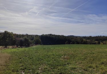
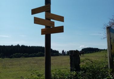
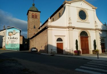
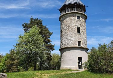
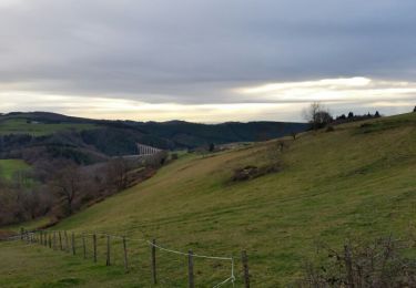
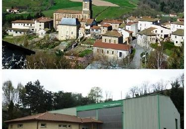
Parking et départ de la marie, remonter en passant devant l'église puis descendre par le «sentier botanique de la Belette». Pour plus d’infos, visitez le site de l' Office de Tourisme des Montagnes du Matin. Les Montagnes du Matin sont situées sur la partie ouest des monts du Lyonnais, côté Loire (42), vers la plaine du Forez. Carte avec le plan du réseau des 26 itinéraires VTT dans les Montagnes du Matin (350 km de sentiers aménagés) disponible dans les OT/SI de la région (Panissières, Violay, Balbigny, Roanne). Autre départ possible : Montchal (42360)
Plaatsbepaling
Opmerkingen
Wandeltochten in de omgeving
![Tocht Stappen Violay - Randonnée de Violay - Photo](https://media.geolcdn.com/t/375/260/b78157fd-81fd-4bc7-9694-a9bddd2f8a7a.jpg&format=jpg&maxdim=2)
![Stappen Stappen](https://static1.geolcdn.com/sitytour/trail-icons/101.png)
Stappen
![](/images/other/stat-length.png)
![](https://static1.geolcdn.com/siteimages/upload/files/16400158638029165_repeat_loop_refresh_sync_direction_icon.png)
![Tocht Stappen Violay - Randonnée au dessus de Violay - Photo](https://media.geolcdn.com/t/375/260/914fdf13-9068-40b2-8a60-d21e2612afe3.jpg&format=jpg&maxdim=2)
![Stappen Stappen](https://static1.geolcdn.com/sitytour/trail-icons/101.png)
Stappen
![](/images/other/stat-length.png)
![](https://static1.geolcdn.com/siteimages/upload/files/16400158638029165_repeat_loop_refresh_sync_direction_icon.png)
![Tocht Stappen Montchal - randonnée de Montchal - Photo](https://media.geolcdn.com/t/375/260/ca094be3-a112-4258-b8ae-8d5bd31d7ca6.jpg&format=jpg&maxdim=2)
![Stappen Stappen](https://static1.geolcdn.com/sitytour/trail-icons/101.png)
Stappen
![](/images/other/stat-length.png)
![](https://static1.geolcdn.com/siteimages/upload/files/16400158638029165_repeat_loop_refresh_sync_direction_icon.png)
![Tocht Stappen Sainte-Agathe-en-Donzy - Sentier botanique de la Belette - Photo](https://media.geolcdn.com/t/375/260/ext.jpg?maxdim=2&url=https%3A%2F%2Fstatic1.geolcdn.com%2Fsiteimages%2Fupload%2Ffiles%2F1553511878bg_sport_marche.png)
![Stappen Stappen](https://static1.geolcdn.com/sitytour/trail-icons/101.png)
Stappen
![](/images/other/stat-length.png)
![](https://static1.geolcdn.com/siteimages/upload/files/16400158638029165_repeat_loop_refresh_sync_direction_icon.png)
![Tocht Stappen Violay - La Tour de Matagrin avec un départ à Violay - Photo](https://media.geolcdn.com/t/375/260/fa198858-1080-46a0-8e5e-b317e5494583.jpg&format=jpg&maxdim=2)
![Stappen Stappen](https://static1.geolcdn.com/sitytour/trail-icons/101.png)
Stappen
![](/images/other/stat-length.png)
![](https://static1.geolcdn.com/siteimages/upload/files/16400158638029165_repeat_loop_refresh_sync_direction_icon.png)
![Tocht Stappen Violay - Départ de Violay - Photo](https://media.geolcdn.com/t/375/260/133748ea-395d-4ae8-8676-41a51b16fd2c.jpg&format=jpg&maxdim=2)
![Stappen Stappen](https://static1.geolcdn.com/sitytour/trail-icons/101.png)
Stappen
![](/images/other/stat-length.png)
![](https://static1.geolcdn.com/siteimages/upload/files/16400158638029165_repeat_loop_refresh_sync_direction_icon.png)
![Tocht Stappen Violay - Violay - La Tour Matagrin - Photo](https://media.geolcdn.com/t/375/260/9fd45418-c881-4167-b97b-25160dce28f5.jpg&format=jpg&maxdim=2)
![Stappen Stappen](https://static1.geolcdn.com/sitytour/trail-icons/101.png)
Stappen
![](/images/other/stat-length.png)
![](https://static1.geolcdn.com/siteimages/upload/files/16400158638029165_repeat_loop_refresh_sync_direction_icon.png)
![Tocht Stappen Sainte-Colombe-sur-Gand - viaduc du marteau - Photo](https://media.geolcdn.com/t/375/260/ext.jpg?maxdim=2&url=https%3A%2F%2Fservices.sitytrail.com%2FGeolivesWS%2FDownloadMedia.ashx%3FTrailID%3D505449%26Media%3Dfix__20151223160521.jpg)
![Stappen Stappen](https://static1.geolcdn.com/sitytour/trail-icons/101.png)
Stappen
![](/images/other/stat-length.png)
![](https://static1.geolcdn.com/siteimages/upload/files/16400158638029165_repeat_loop_refresh_sync_direction_icon.png)
![Tocht Mountainbike Sainte-Colombe-sur-Gand - Le viaduc du Pont Marteau - Sainte Colombe sur Gand - Photo](https://media.geolcdn.com/t/375/260/ext.jpg?maxdim=2&url=https%3A%2F%2Fservices.sitytrail.com%2FGeolivesWS%2FDownloadMedia.ashx%3FTrailID%3D317753%26Media%3D17064_6.jpg)
![Mountainbike Mountainbike](https://static1.geolcdn.com/sitytour/trail-icons/202.png)
Mountainbike
![](/images/other/stat-length.png)
![](https://static1.geolcdn.com/siteimages/upload/files/16400158638029165_repeat_loop_refresh_sync_direction_icon.png)