![](/images/other/stat-length.png)
![Tocht Stappen Cubières - #6 GR70 Le Bleymard - Finiels - Photo](https://media.geolcdn.com/t/1900/400/ext.pjpeg?maxdim=2&url=https%3A%2F%2Fstatic1.geolcdn.com%2Fsiteimages%2Fupload%2Ffiles%2F1553511878bg_sport_marche.png)
#6 GR70 Le Bleymard - Finiels
magalette
Gebruiker
![Lengte](/images/other/stat-length.png)
Lengte
14,8 km
![Max. hoogte](https://static1.geolcdn.com/siteimages/upload/files/1508320355ic_sort_altitude_max_24dp.png)
Max. hoogte
1699 m
![Positief hoogteverschil](https://static1.geolcdn.com/siteimages/upload/files/1508320355ic_sort_den_pos_24dp.png)
Positief hoogteverschil
654 m
![Km-Effort](/images/other/stat-length.png)
Km-Effort
23 km
![Min. hoogte](https://static1.geolcdn.com/siteimages/upload/files/1508320355ic_sort_altitude_min_24dp.png)
Min. hoogte
1062 m
![Negatief hoogteverschil](https://static1.geolcdn.com/siteimages/upload/files/1508320355ic_sort_den_neg_24dp.png)
Negatief hoogteverschil
498 m
![Boucle](https://static1.geolcdn.com/siteimages/upload/files/16400158638029165_repeat_loop_refresh_sync_direction_icon.png)
Boucle
Neen
Datum van aanmaak :
2014-12-10 00:00:00.0
Laatste wijziging :
2014-12-10 00:00:00.0
![Stappen](https://static1.geolcdn.com/sitytour/trail-icons/101.png)
4h50
Moeilijkheid : Medium
![Scan deze QR-code om de tocht te openen in de SityTrail-applicatie](https://capi.geolives.com/qq0zvz2zws4bq2lad0pu/sitytour/trails/171665/qr.png?size=200)
Gratisgps-wandelapplicatie
Over ons
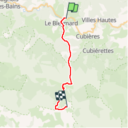
Tocht Stappen van 14,8 km beschikbaar op Occitanië, Lozère, Cubières. Deze tocht wordt voorgesteld door magalette.
Beschrijving
6ème étape de notre randonnée sur les traces de RL Stevenson entre Le Bleymard et Finiels. Etape au camping La Barette à Finiels
Plaatsbepaling
Land:
France
Regio :
Occitanië
Departement/Provincie :
Lozère
Gemeente :
Cubières
Locatie:
Unknown
Vertrek:(Dec)
Vertrek:(UTM)
559117 ; 4926711 (31T) N.
Opmerkingen
Wandeltochten in de omgeving
![Tocht Stappen Mont Lozère et Goulet - Bleymar _ Le Pont Montvert - Photo](https://media.geolcdn.com/t/375/260/ext.jpg?maxdim=2&url=https%3A%2F%2Fservices.sitytrail.com%2FGeolivesWS%2FDownloadMedia.ashx%3FTrailID%3D463465%26Media%3Dfix__20150819092348.jpg)
![Stappen Stappen](https://static1.geolcdn.com/sitytour/trail-icons/101.png)
Bleymar _ Le Pont Montvert
Stappen
Moeilijk
(1)
Mont Lozère et Goulet,
Occitanië,
Lozère,
France
![](/images/other/stat-length.png)
22 km | 32 km-effort
5h 19min
![](https://static1.geolcdn.com/siteimages/upload/files/16400158638029165_repeat_loop_refresh_sync_direction_icon.png)
Neen
![Tocht Stappen Mont Lozère et Goulet - Chemin de Stevenson - Le Bleymard vers Le Pont de Montvert - Photo](https://media.geolcdn.com/t/375/260/ext.jpg?maxdim=2&url=https%3A%2F%2Fservices.sitytrail.com%2FGeolivesWS%2FDownloadMedia.ashx%3FTrailID%3D109272%26Media%3D3392_1.jpg)
![Stappen Stappen](https://static1.geolcdn.com/sitytour/trail-icons/101.png)
Chemin de Stevenson - Le Bleymard vers Le Pont de Montvert
Stappen
Moeilijk
(1)
Mont Lozère et Goulet,
Occitanië,
Lozère,
France
![](/images/other/stat-length.png)
18,9 km | 28 km-effort
4h 30min
![](https://static1.geolcdn.com/siteimages/upload/files/16400158638029165_repeat_loop_refresh_sync_direction_icon.png)
Neen
![Tocht Stappen Mont Lozère et Goulet - 12-05-2023 E7 Bonnetés - Le Pont de Monvers - Photo](https://media.geolcdn.com/t/375/260/d16bfac8-7ce8-4044-a757-ffb026543eb4.jpg&format=jpg&maxdim=2)
![Stappen Stappen](https://static1.geolcdn.com/sitytour/trail-icons/101.png)
12-05-2023 E7 Bonnetés - Le Pont de Monvers
Stappen
Moeilijk
Mont Lozère et Goulet,
Occitanië,
Lozère,
France
![](/images/other/stat-length.png)
25 km | 35 km-effort
7h 59min
![](https://static1.geolcdn.com/siteimages/upload/files/16400158638029165_repeat_loop_refresh_sync_direction_icon.png)
Neen
![Tocht Stappen Mont Lozère et Goulet - Stevenson étape 8 - Photo](https://media.geolcdn.com/t/375/260/b34e09af-9026-4127-8636-d1e451b59807.jpg&format=jpg&maxdim=2)
![Stappen Stappen](https://static1.geolcdn.com/sitytour/trail-icons/101.png)
Stevenson étape 8
Stappen
Moeilijk
Mont Lozère et Goulet,
Occitanië,
Lozère,
France
![](/images/other/stat-length.png)
20 km | 30 km-effort
5h 29min
![](https://static1.geolcdn.com/siteimages/upload/files/16400158638029165_repeat_loop_refresh_sync_direction_icon.png)
Neen
![Tocht Stappen Mont Lozère et Goulet - Le Bleymard_La Crouzette par le chemin Stevenson_10,5Km - Photo](https://media.geolcdn.com/t/375/260/ext.jpg?maxdim=2&url=https%3A%2F%2Fstatic1.geolcdn.com%2Fsiteimages%2Fupload%2Ffiles%2F1553511878bg_sport_marche.png)
![Stappen Stappen](https://static1.geolcdn.com/sitytour/trail-icons/101.png)
Le Bleymard_La Crouzette par le chemin Stevenson_10,5Km
Stappen
Moeilijk
(1)
Mont Lozère et Goulet,
Occitanië,
Lozère,
France
![](/images/other/stat-length.png)
10,6 km | 14,4 km-effort
3h 2min
![](https://static1.geolcdn.com/siteimages/upload/files/16400158638029165_repeat_loop_refresh_sync_direction_icon.png)
Ja
![Tocht Stappen Mont Lozère et Goulet - Etape 6 le Bleymard / Pont Montvert - Photo](https://media.geolcdn.com/t/375/260/a6e4cbab-29ac-4753-9ee3-6bb7657590cb.jpg&format=jpg&maxdim=2)
![Stappen Stappen](https://static1.geolcdn.com/sitytour/trail-icons/101.png)
Etape 6 le Bleymard / Pont Montvert
Stappen
Moeilijk
Mont Lozère et Goulet,
Occitanië,
Lozère,
France
![](/images/other/stat-length.png)
20 km | 29 km-effort
5h 31min
![](https://static1.geolcdn.com/siteimages/upload/files/16400158638029165_repeat_loop_refresh_sync_direction_icon.png)
Neen
![Tocht Mountainbike Mont Lozère et Goulet - Fait GTMC 2022 E3 3b - Photo](https://media.geolcdn.com/t/375/260/46bf832c-db4a-40a5-a543-74cca6354959.jpg&format=jpg&maxdim=2)
![Mountainbike Mountainbike](https://static1.geolcdn.com/sitytour/trail-icons/202.png)
Fait GTMC 2022 E3 3b
Mountainbike
Moeilijk
Mont Lozère et Goulet,
Occitanië,
Lozère,
France
![](/images/other/stat-length.png)
51 km | 68 km-effort
7h 43min
![](https://static1.geolcdn.com/siteimages/upload/files/16400158638029165_repeat_loop_refresh_sync_direction_icon.png)
Neen
![Tocht Stappen Mont Lozère et Goulet - Pont de Montvert - Photo](https://media.geolcdn.com/t/375/260/ef737a4f-a7c1-4642-affe-b45fe92c561f.jpg&format=jpg&maxdim=2)
![Stappen Stappen](https://static1.geolcdn.com/sitytour/trail-icons/101.png)
Pont de Montvert
Stappen
Zeer moeilijk
Mont Lozère et Goulet,
Occitanië,
Lozère,
France
![](/images/other/stat-length.png)
19,4 km | 29 km-effort
6h 52min
![](https://static1.geolcdn.com/siteimages/upload/files/16400158638029165_repeat_loop_refresh_sync_direction_icon.png)
Neen
![Tocht Stappen Mont Lozère et Goulet - Le Bleymard Le Pont de Montvert - Photo](https://media.geolcdn.com/t/375/260/bc8ce64f-cd1b-45a2-88b4-fb2df0b1f341.jpg&format=jpg&maxdim=2)
![Stappen Stappen](https://static1.geolcdn.com/sitytour/trail-icons/101.png)
Le Bleymard Le Pont de Montvert
Stappen
Moeilijk
Mont Lozère et Goulet,
Occitanië,
Lozère,
France
![](/images/other/stat-length.png)
20 km | 30 km-effort
6h 50min
![](https://static1.geolcdn.com/siteimages/upload/files/16400158638029165_repeat_loop_refresh_sync_direction_icon.png)
Neen