![](/images/other/stat-length.png)
![Tocht Stappen Athée-sur-Cher - Athée sur Cher - Photo](https://media.geolcdn.com/t/1900/400/ext.pjpeg?maxdim=2&url=https%3A%2F%2Fstatic1.geolcdn.com%2Fsiteimages%2Fupload%2Ffiles%2F1553511878bg_sport_marche.png)
Athée sur Cher
LEMENIO
Gebruiker
![Lengte](/images/other/stat-length.png)
Lengte
12,6 km
![Max. hoogte](https://static1.geolcdn.com/siteimages/upload/files/1508320355ic_sort_altitude_max_24dp.png)
Max. hoogte
99 m
![Positief hoogteverschil](https://static1.geolcdn.com/siteimages/upload/files/1508320355ic_sort_den_pos_24dp.png)
Positief hoogteverschil
128 m
![Km-Effort](/images/other/stat-length.png)
Km-Effort
14,3 km
![Min. hoogte](https://static1.geolcdn.com/siteimages/upload/files/1508320355ic_sort_altitude_min_24dp.png)
Min. hoogte
51 m
![Negatief hoogteverschil](https://static1.geolcdn.com/siteimages/upload/files/1508320355ic_sort_den_neg_24dp.png)
Negatief hoogteverschil
130 m
![Boucle](https://static1.geolcdn.com/siteimages/upload/files/16400158638029165_repeat_loop_refresh_sync_direction_icon.png)
Boucle
Ja
Datum van aanmaak :
2014-12-10 00:00:00.0
Laatste wijziging :
2014-12-10 00:00:00.0
![Stappen](https://static1.geolcdn.com/sitytour/trail-icons/101.png)
3h09
Moeilijkheid : Gemakkelijk
![Scan deze QR-code om de tocht te openen in de SityTrail-applicatie](https://capi.geolives.com/qq0zvz2zws4bq2lad0pu/sitytour/trails/171512/qr.png?size=200)
Gratisgps-wandelapplicatie
Over ons
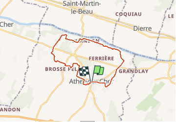
Tocht Stappen van 12,6 km beschikbaar op Centre-Val de Loire, Indre-et-Loire, Athée-sur-Cher. Deze tocht wordt voorgesteld door LEMENIO.
Beschrijving
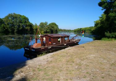
Départ place de l'église: à l'arrivée aux abords du cher,il est possible de prendre le chemin qui longe la rivière (par temps sec).
Plaatsbepaling
Land:
France
Regio :
Centre-Val de Loire
Departement/Provincie :
Indre-et-Loire
Gemeente :
Athée-sur-Cher
Locatie:
Unknown
Vertrek:(Dec)
Vertrek:(UTM)
342522 ; 5242925 (31T) N.
Opmerkingen
Wandeltochten in de omgeving
![Tocht Stappen Saint-Martin-le-Beau - Saint-Martin-le-Beau - Zig zag Dierre - 22km 330m 4h45 (1h) - 2024 10 05 - Photo](https://media.geolcdn.com/t/375/260/8ed56c4c-a814-413e-ad4d-d4d7b54a0592.jpg&format=jpg&maxdim=2)
![Stappen Stappen](https://static1.geolcdn.com/sitytour/trail-icons/101.png)
Saint-Martin-le-Beau - Zig zag Dierre - 22km 330m 4h45 (1h) - 2024 10 05
Stappen
Medium
Saint-Martin-le-Beau,
Centre-Val de Loire,
Indre-et-Loire,
France
![](/images/other/stat-length.png)
22 km | 26 km-effort
4h 45min
![](https://static1.geolcdn.com/siteimages/upload/files/16400158638029165_repeat_loop_refresh_sync_direction_icon.png)
Ja
![Tocht Stappen Saint-Martin-le-Beau - Saint-Martin-le-Beau - PR Entre Vignes et Forêts - 11.8km 120m 2h45 (45mn) - 2023 10 07 - Photo](https://media.geolcdn.com/t/375/260/24ce2aa4-4932-408c-a436-3f83b6744ce9.jpg&format=jpg&maxdim=2)
![Stappen Stappen](https://static1.geolcdn.com/sitytour/trail-icons/101.png)
Saint-Martin-le-Beau - PR Entre Vignes et Forêts - 11.8km 120m 2h45 (45mn) - ...
Stappen
Medium
Saint-Martin-le-Beau,
Centre-Val de Loire,
Indre-et-Loire,
France
![](/images/other/stat-length.png)
11,8 km | 13,4 km-effort
2h 45min
![](https://static1.geolcdn.com/siteimages/upload/files/16400158638029165_repeat_loop_refresh_sync_direction_icon.png)
Ja
![Tocht Stappen Saint-Martin-le-Beau - Saint-Martin-le-Beau - Nitray GR41 Azay-sur-Cher - 23.2km 185m 5h15 (40mn) - 2023 10 04 - Photo](https://media.geolcdn.com/t/375/260/4b768c7a-d65d-4d1c-bb56-1d0e8b4c83bb.jpg&format=jpg&maxdim=2)
![Stappen Stappen](https://static1.geolcdn.com/sitytour/trail-icons/101.png)
Saint-Martin-le-Beau - Nitray GR41 Azay-sur-Cher - 23.2km 185m 5h15 (40mn) - ...
Stappen
Gemakkelijk
Saint-Martin-le-Beau,
Centre-Val de Loire,
Indre-et-Loire,
France
![](/images/other/stat-length.png)
23 km | 26 km-effort
5h 15min
![](https://static1.geolcdn.com/siteimages/upload/files/16400158638029165_repeat_loop_refresh_sync_direction_icon.png)
Ja
![Tocht Stappen Dierre - Dierre - St-Martin-le-Beau - 15.9km 230m 3h35 - 2023 02 26 - Photo](https://media.geolcdn.com/t/375/260/f1e8a642-9a7c-4bcc-aef6-e89c45620d53.jpg&format=jpg&maxdim=2)
![Stappen Stappen](https://static1.geolcdn.com/sitytour/trail-icons/101.png)
Dierre - St-Martin-le-Beau - 15.9km 230m 3h35 - 2023 02 26
Stappen
Gemakkelijk
Dierre,
Centre-Val de Loire,
Indre-et-Loire,
France
![](/images/other/stat-length.png)
15,9 km | 19 km-effort
3h 35min
![](https://static1.geolcdn.com/siteimages/upload/files/16400158638029165_repeat_loop_refresh_sync_direction_icon.png)
Ja
![Tocht Stappen Bléré - Bléré - Fontenay - 15.9km 145m 3h45 - 2022 07 31 - Photo](https://media.geolcdn.com/t/375/260/1cdd1517-7a96-427a-95fc-8223942e32de.jpg&format=jpg&maxdim=2)
![Stappen Stappen](https://static1.geolcdn.com/sitytour/trail-icons/101.png)
Bléré - Fontenay - 15.9km 145m 3h45 - 2022 07 31
Stappen
Gemakkelijk
Bléré,
Centre-Val de Loire,
Indre-et-Loire,
France
![](/images/other/stat-length.png)
15,9 km | 17,8 km-effort
3h 45min
![](https://static1.geolcdn.com/siteimages/upload/files/16400158638029165_repeat_loop_refresh_sync_direction_icon.png)
Ja
![Tocht Stappen Athée-sur-Cher - Athée-sur-Cher - Port Chandon - 18km 140m 4h05 - 2022 07 24 - Photo](https://media.geolcdn.com/t/375/260/06bf13d7-1472-4195-8c45-3f1e94a53c00.jpg&format=jpg&maxdim=2)
![Stappen Stappen](https://static1.geolcdn.com/sitytour/trail-icons/101.png)
Athée-sur-Cher - Port Chandon - 18km 140m 4h05 - 2022 07 24
Stappen
Gemakkelijk
Athée-sur-Cher,
Centre-Val de Loire,
Indre-et-Loire,
France
![](/images/other/stat-length.png)
18 km | 19,8 km-effort
4h 5min
![](https://static1.geolcdn.com/siteimages/upload/files/16400158638029165_repeat_loop_refresh_sync_direction_icon.png)
Ja
![Tocht Stappen Athée-sur-Cher - Athée-sur-Cher - la Halbutterie - 18.6km 155m 3h50 - 2006 05 14 - Photo](https://media.geolcdn.com/t/375/260/69b18714-2dc3-4942-abd6-2e1b26c33ac2.jpg&format=jpg&maxdim=2)
![Stappen Stappen](https://static1.geolcdn.com/sitytour/trail-icons/101.png)
Athée-sur-Cher - la Halbutterie - 18.6km 155m 3h50 - 2006 05 14
Stappen
Gemakkelijk
Athée-sur-Cher,
Centre-Val de Loire,
Indre-et-Loire,
France
![](/images/other/stat-length.png)
18,6 km | 21 km-effort
3h 50min
![](https://static1.geolcdn.com/siteimages/upload/files/16400158638029165_repeat_loop_refresh_sync_direction_icon.png)
Ja
![Tocht Stappen Saint-Martin-le-Beau - st martin le beau - Photo](https://media.geolcdn.com/t/375/260/66862b17-5206-4ca2-9cb2-31d43cb2c5ae.jpg&format=jpg&maxdim=2)
![Stappen Stappen](https://static1.geolcdn.com/sitytour/trail-icons/101.png)
st martin le beau
Stappen
Heel gemakkelijk
Saint-Martin-le-Beau,
Centre-Val de Loire,
Indre-et-Loire,
France
![](/images/other/stat-length.png)
25 km | 29 km-effort
5h 54min
![](https://static1.geolcdn.com/siteimages/upload/files/16400158638029165_repeat_loop_refresh_sync_direction_icon.png)
Neen
![Tocht Stappen Athée-sur-Cher - Nitray - Bléré - AR - 2015 11 15 - Photo](https://media.geolcdn.com/t/375/260/d33c00a1-86cc-4a2e-816c-f9d34f6d233e.jpg&format=jpg&maxdim=2)
![Stappen Stappen](https://static1.geolcdn.com/sitytour/trail-icons/101.png)
Nitray - Bléré - AR - 2015 11 15
Stappen
Gemakkelijk
Athée-sur-Cher,
Centre-Val de Loire,
Indre-et-Loire,
France
![](/images/other/stat-length.png)
13,8 km | 15,5 km-effort
2h 25min
![](https://static1.geolcdn.com/siteimages/upload/files/16400158638029165_repeat_loop_refresh_sync_direction_icon.png)
Ja