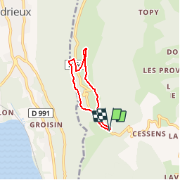
![](/images/other/stat-length.png)
![Tocht Stappen Entrelacs - 73- Cessens-Col du Sapeney - Photo](https://media.geolcdn.com/t/1900/400/ext.pjpeg?maxdim=2&url=https%3A%2F%2Fstatic1.geolcdn.com%2Fsiteimages%2Fupload%2Ffiles%2F1553511878bg_sport_marche.png)
73- Cessens-Col du Sapeney
cavpsy74
Gebruiker
![Lengte](/images/other/stat-length.png)
![Max. hoogte](https://static1.geolcdn.com/siteimages/upload/files/1508320355ic_sort_altitude_max_24dp.png)
![Positief hoogteverschil](https://static1.geolcdn.com/siteimages/upload/files/1508320355ic_sort_den_pos_24dp.png)
![Km-Effort](/images/other/stat-length.png)
![Min. hoogte](https://static1.geolcdn.com/siteimages/upload/files/1508320355ic_sort_altitude_min_24dp.png)
![Negatief hoogteverschil](https://static1.geolcdn.com/siteimages/upload/files/1508320355ic_sort_den_neg_24dp.png)
![Boucle](https://static1.geolcdn.com/siteimages/upload/files/16400158638029165_repeat_loop_refresh_sync_direction_icon.png)
![Stappen](https://static1.geolcdn.com/sitytour/trail-icons/101.png)
1h25
Moeilijkheid : Gemakkelijk
![Scan deze QR-code om de tocht te openen in de SityTrail-applicatie](https://capi.geolives.com/qq0zvz2zws4bq2lad0pu/sitytour/trails/169014/qr.png?size=200)
Gratisgps-wandelapplicatie
Over ons
Tocht Stappen van 4,3 km beschikbaar op Auvergne-Rhône-Alpes, Savoie, Entrelacs. Deze tocht wordt voorgesteld door cavpsy74.
Beschrijving
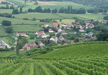
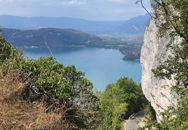
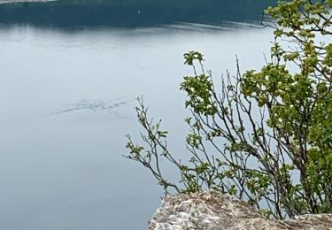
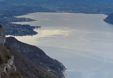
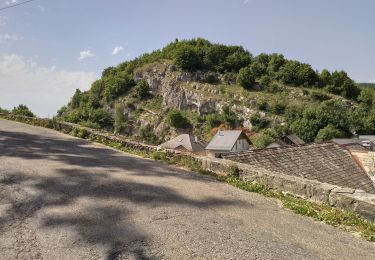
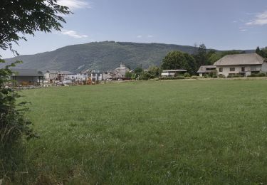
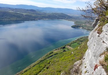
En partant du parking de Notre-Dame de la Salette... Un paysage magnifique, ne pas manquer le belvédère du Sapenay (aire d'envol parapentes et deltaplanes)et son point de vue sur le Lac du Bourget, la Chautagne, la plaine du Rhône et le Grand Colombier...Possible en raquettes l'hiver.
Plaatsbepaling
Opmerkingen
Wandeltochten in de omgeving
![Tocht Stappen Chindrieux - Sur les Pas des Huguenots - Chindrieux - Serrières en Chautagne - Photo](https://media.geolcdn.com/t/375/260/ext.jpg?maxdim=2&url=https%3A%2F%2Fservices.sitytrail.com%2FGeolivesWS%2FDownloadMedia.ashx%3FTrailID%3D129664%26Media%3D13193_3.jpg)
![Stappen Stappen](https://static1.geolcdn.com/sitytour/trail-icons/101.png)
Stappen
![](/images/other/stat-length.png)
![](https://static1.geolcdn.com/siteimages/upload/files/16400158638029165_repeat_loop_refresh_sync_direction_icon.png)
![Tocht Stappen Entrelacs - 30-08-2022 La Chambotte - Croix de Meyrieu - Photo](https://media.geolcdn.com/t/375/260/c8704b3f-8048-446a-89ef-a79ba6fd2504.jpg&format=jpg&maxdim=2)
![Stappen Stappen](https://static1.geolcdn.com/sitytour/trail-icons/101.png)
Stappen
![](/images/other/stat-length.png)
![](https://static1.geolcdn.com/siteimages/upload/files/16400158638029165_repeat_loop_refresh_sync_direction_icon.png)
![Tocht Stappen Massingy - CLERGEON - Photo](https://media.geolcdn.com/t/375/260/ext.jpg?maxdim=2&url=https%3A%2F%2Fservices.sitytrail.com%2FGeolivesWS%2FDownloadMedia.ashx%3FTrailID%3D474185%26Media%3Dc01eb5a7-bf72-4ffc-98fa-1e923f8f3f43.jpg)
![Stappen Stappen](https://static1.geolcdn.com/sitytour/trail-icons/101.png)
Stappen
![](/images/other/stat-length.png)
![](https://static1.geolcdn.com/siteimages/upload/files/16400158638029165_repeat_loop_refresh_sync_direction_icon.png)
![Tocht Stappen Entrelacs - SAPENAY / CLERGEON: GRANDE CUVE - Photo](https://media.geolcdn.com/t/375/260/81ea709e-f7b9-477c-93c3-923ab4e12c63.jpg&format=jpg&maxdim=2)
![Stappen Stappen](https://static1.geolcdn.com/sitytour/trail-icons/101.png)
Stappen
![](/images/other/stat-length.png)
![](https://static1.geolcdn.com/siteimages/upload/files/16400158638029165_repeat_loop_refresh_sync_direction_icon.png)
![Tocht Stappen Entrelacs - Belvédère de la Chambotte - Mont de Corsuet - Photo](https://media.geolcdn.com/t/375/260/320ab627-8a91-46ea-b3a7-34db91702556.jpg&format=jpg&maxdim=2)
![Stappen Stappen](https://static1.geolcdn.com/sitytour/trail-icons/101.png)
Stappen
![](/images/other/stat-length.png)
![](https://static1.geolcdn.com/siteimages/upload/files/16400158638029165_repeat_loop_refresh_sync_direction_icon.png)
![Tocht Stappen Entrelacs - La chambotte mont laval aix les bains - Photo](https://media.geolcdn.com/t/375/260/83780321-69f1-4ca1-9229-55e6ffa1c410.jpg&format=jpg&maxdim=2)
![Stappen Stappen](https://static1.geolcdn.com/sitytour/trail-icons/101.png)
Stappen
![](/images/other/stat-length.png)
![](https://static1.geolcdn.com/siteimages/upload/files/16400158638029165_repeat_loop_refresh_sync_direction_icon.png)
![Tocht Stappen Entrelacs - Bellevedere de la Chambotte - Photo](https://media.geolcdn.com/t/375/260/69045582-c557-4058-9efb-585a49f48118.jpg&format=jpg&maxdim=2)
![Stappen Stappen](https://static1.geolcdn.com/sitytour/trail-icons/101.png)
Stappen
![](/images/other/stat-length.png)
![](https://static1.geolcdn.com/siteimages/upload/files/16400158638029165_repeat_loop_refresh_sync_direction_icon.png)
![Tocht Stappen La Biolle - La Biolle - Photo](https://media.geolcdn.com/t/375/260/fe7a0a14-cbca-4a8d-bceb-b57e7cb64bdc.jpg&format=jpg&maxdim=2)
![Stappen Stappen](https://static1.geolcdn.com/sitytour/trail-icons/101.png)
Stappen
![](/images/other/stat-length.png)
![](https://static1.geolcdn.com/siteimages/upload/files/16400158638029165_repeat_loop_refresh_sync_direction_icon.png)
![Tocht Stappen Entrelacs - CHAMBOTTE: DECRASSAGE SUR LES CRETES - Photo](https://media.geolcdn.com/t/375/260/ddde69c3-3462-4077-ba6c-e835ee2db56d.jpg&format=jpg&maxdim=2)
![Stappen Stappen](https://static1.geolcdn.com/sitytour/trail-icons/101.png)
Stappen
![](/images/other/stat-length.png)
![](https://static1.geolcdn.com/siteimages/upload/files/16400158638029165_repeat_loop_refresh_sync_direction_icon.png)