![](/images/other/stat-length.png)
![Tocht Stappen Torcy - le tour des lacs - Photo](https://media.geolcdn.com/t/1900/400/ext.pjpeg?maxdim=2&url=https%3A%2F%2Fservices.sitytrail.com%2FGeolivesWS%2FDownloadMedia.ashx%3FTrailID%3D168526%26Media%3D20130104130507.jpeg)
le tour des lacs
jojoh2o
Gebruiker
![Lengte](/images/other/stat-length.png)
Lengte
6 km
![Max. hoogte](https://static1.geolcdn.com/siteimages/upload/files/1508320355ic_sort_altitude_max_24dp.png)
Max. hoogte
86 m
![Positief hoogteverschil](https://static1.geolcdn.com/siteimages/upload/files/1508320355ic_sort_den_pos_24dp.png)
Positief hoogteverschil
55 m
![Km-Effort](/images/other/stat-length.png)
Km-Effort
6,8 km
![Min. hoogte](https://static1.geolcdn.com/siteimages/upload/files/1508320355ic_sort_altitude_min_24dp.png)
Min. hoogte
44 m
![Negatief hoogteverschil](https://static1.geolcdn.com/siteimages/upload/files/1508320355ic_sort_den_neg_24dp.png)
Negatief hoogteverschil
60 m
![Boucle](https://static1.geolcdn.com/siteimages/upload/files/16400158638029165_repeat_loop_refresh_sync_direction_icon.png)
Boucle
Ja
Datum van aanmaak :
2014-12-10 00:00:00.0
Laatste wijziging :
2014-12-10 00:00:00.0
![Stappen](https://static1.geolcdn.com/sitytour/trail-icons/101.png)
1h05
Moeilijkheid : Heel gemakkelijk
![Scan deze QR-code om de tocht te openen in de SityTrail-applicatie](https://capi.geolives.com/qq0zvz2zws4bq2lad0pu/sitytour/trails/168526/qr.png?size=200)
Gratisgps-wandelapplicatie
Over ons
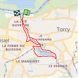
Tocht Stappen van 6 km beschikbaar op Île-de-France, Seine-et-Marne, Torcy. Deze tocht wordt voorgesteld door jojoh2o.
Beschrijving
Ballade facile praticable par tous les temps. depart du parking de la Mairie de Noisiel ou du parking de Nestle (seulement le week-end)
Plaatsbepaling
Land:
France
Regio :
Île-de-France
Departement/Provincie :
Seine-et-Marne
Gemeente :
Torcy
Locatie:
Unknown
Vertrek:(Dec)
Vertrek:(UTM)
472828 ; 5411422 (31U) N.
Opmerkingen
Wandeltochten in de omgeving
![Tocht Stappen Chelles - GRP CV-IDF 06 - Photo](https://media.geolcdn.com/t/375/260/ext.jpg?maxdim=2&url=https%3A%2F%2Fmedia.geolcdn.com%2Ff%2F3e851a57-05bf-470c-9490-37cd07bf40e9.jpg)
![Stappen Stappen](https://static1.geolcdn.com/sitytour/trail-icons/101.png)
GRP CV-IDF 06
Stappen
Medium
(1)
Chelles,
Île-de-France,
Seine-et-Marne,
France
![](/images/other/stat-length.png)
15 km | 16,7 km-effort
3h 47min
![](https://static1.geolcdn.com/siteimages/upload/files/16400158638029165_repeat_loop_refresh_sync_direction_icon.png)
Neen
![Tocht Stappen Saint-Thibault-des-Vignes - Du Parc de Rentilly au Ru de la Gondoire - Photo](https://media.geolcdn.com/t/375/260/ext.jpg?maxdim=2&url=https%3A%2F%2Fmedia.geolcdn.com%2Ff%2F5bd80e6c-4375-4eab-8729-514b46662b13.JPG)
![Stappen Stappen](https://static1.geolcdn.com/sitytour/trail-icons/101.png)
Du Parc de Rentilly au Ru de la Gondoire
Stappen
Moeilijk
(1)
Saint-Thibault-des-Vignes,
Île-de-France,
Seine-et-Marne,
France
![](/images/other/stat-length.png)
21 km | 24 km-effort
5h 20min
![](https://static1.geolcdn.com/siteimages/upload/files/16400158638029165_repeat_loop_refresh_sync_direction_icon.png)
Ja
![Tocht Stappen Saint-Thibault-des-Vignes - Du Parc de Rentilly au Vallon de la Brosse - Photo](https://media.geolcdn.com/t/375/260/ext.jpg?maxdim=2&url=https%3A%2F%2Fstatic1.geolcdn.com%2Fsiteimages%2Fupload%2Ffiles%2F1553511878bg_sport_marche.png)
![Stappen Stappen](https://static1.geolcdn.com/sitytour/trail-icons/101.png)
Du Parc de Rentilly au Vallon de la Brosse
Stappen
Medium
(4)
Saint-Thibault-des-Vignes,
Île-de-France,
Seine-et-Marne,
France
![](/images/other/stat-length.png)
9,8 km | 11,3 km-effort
2h 33min
![](https://static1.geolcdn.com/siteimages/upload/files/16400158638029165_repeat_loop_refresh_sync_direction_icon.png)
Ja
![Tocht Te voet Bussy-Saint-Georges - Du Parc de Rentilly au Vallon de la Brosse - Photo](https://media.geolcdn.com/t/375/260/ext.jpg?maxdim=2&url=https%3A%2F%2Fstatic1.geolcdn.com%2Fsiteimages%2Fupload%2Ffiles%2F1545311037marcheuse_200dpi.jpg)
![Te voet Te voet](https://static1.geolcdn.com/sitytour/trail-icons/100.png)
Du Parc de Rentilly au Vallon de la Brosse
Te voet
Heel gemakkelijk
(1)
Bussy-Saint-Georges,
Île-de-France,
Seine-et-Marne,
France
![](/images/other/stat-length.png)
5 km | 5,8 km-effort
1h 55min
![](https://static1.geolcdn.com/siteimages/upload/files/16400158638029165_repeat_loop_refresh_sync_direction_icon.png)
Ja
![Tocht Stappen Noisiel - Noisiel Grand parcours - Photo](https://media.geolcdn.com/t/375/260/ext.jpg?maxdim=2&url=https%3A%2F%2Fstatic1.geolcdn.com%2Fsiteimages%2Fupload%2Ffiles%2F1553511878bg_sport_marche.png)
![Stappen Stappen](https://static1.geolcdn.com/sitytour/trail-icons/101.png)
Noisiel Grand parcours
Stappen
Gemakkelijk
(1)
Noisiel,
Île-de-France,
Seine-et-Marne,
France
![](/images/other/stat-length.png)
21 km | 23 km-effort
4h 50min
![](https://static1.geolcdn.com/siteimages/upload/files/16400158638029165_repeat_loop_refresh_sync_direction_icon.png)
Ja
![Tocht Stappen Gouvernes - Vallée de la Brosse - Photo](https://media.geolcdn.com/t/375/260/ext.jpg?maxdim=2&url=https%3A%2F%2Fstatic1.geolcdn.com%2Fsiteimages%2Fupload%2Ffiles%2F1553511878bg_sport_marche.png)
![Stappen Stappen](https://static1.geolcdn.com/sitytour/trail-icons/101.png)
Vallée de la Brosse
Stappen
Gemakkelijk
(1)
Gouvernes,
Île-de-France,
Seine-et-Marne,
France
![](/images/other/stat-length.png)
7,9 km | 9 km-effort
1h 59min
![](https://static1.geolcdn.com/siteimages/upload/files/16400158638029165_repeat_loop_refresh_sync_direction_icon.png)
Neen
![Tocht Stappen Bussy-Saint-Georges - Boucle Rentilly - Noisiel - Etang de la Brosse - Etang de la Loy - Photo](https://media.geolcdn.com/t/375/260/ext.jpg?maxdim=2&url=https%3A%2F%2Fmedia.geolcdn.com%2Ff%2F2ae0fdb4-e8bd-41dd-b6e1-a0c5cc184bfe.jpg)
![Stappen Stappen](https://static1.geolcdn.com/sitytour/trail-icons/101.png)
Boucle Rentilly - Noisiel - Etang de la Brosse - Etang de la Loy
Stappen
Zeer moeilijk
Bussy-Saint-Georges,
Île-de-France,
Seine-et-Marne,
France
![](/images/other/stat-length.png)
25 km | 29 km-effort
6h 32min
![](https://static1.geolcdn.com/siteimages/upload/files/16400158638029165_repeat_loop_refresh_sync_direction_icon.png)
Ja
![Tocht Stappen Vaires-sur-Marne - Boucle Vaires sur Marne / Noisiel / Chelles - Photo](https://media.geolcdn.com/t/375/260/ext.jpg?maxdim=2&url=https%3A%2F%2Fmedia.geolcdn.com%2Ff%2F449646ea-4419-47cd-8a7f-7bcc77625a1b.jpg)
![Stappen Stappen](https://static1.geolcdn.com/sitytour/trail-icons/101.png)
Boucle Vaires sur Marne / Noisiel / Chelles
Stappen
Gemakkelijk
Vaires-sur-Marne,
Île-de-France,
Seine-et-Marne,
France
![](/images/other/stat-length.png)
21 km | 24 km-effort
4h 33min
![](https://static1.geolcdn.com/siteimages/upload/files/16400158638029165_repeat_loop_refresh_sync_direction_icon.png)
Ja
![Tocht Stappen Lognes - lognes -Rentilly par Torcy, - Photo](https://media.geolcdn.com/t/375/260/ext.jpg?maxdim=2&url=https%3A%2F%2Fmedia.geolcdn.com%2Ff%2Fb73b27a6-cd1c-46f9-979e-c6398dd9106e.jpg)
![Stappen Stappen](https://static1.geolcdn.com/sitytour/trail-icons/101.png)
lognes -Rentilly par Torcy,
Stappen
Moeilijk
Lognes,
Île-de-France,
Seine-et-Marne,
France
![](/images/other/stat-length.png)
15,2 km | 17,1 km-effort
3h 37min
![](https://static1.geolcdn.com/siteimages/upload/files/16400158638029165_repeat_loop_refresh_sync_direction_icon.png)
Ja