![](/images/other/stat-length.png)
![Tocht Stappen Bouaye - Circuit des moulins Bouaye - Photo](https://media.geolcdn.com/t/1900/400/ext.pjpeg?maxdim=2&url=https%3A%2F%2Fstatic1.geolcdn.com%2Fsiteimages%2Fupload%2Ffiles%2F1553511878bg_sport_marche.png)
Circuit des moulins Bouaye
jylera
Gebruiker
![Lengte](/images/other/stat-length.png)
Lengte
11,7 km
![Max. hoogte](https://static1.geolcdn.com/siteimages/upload/files/1508320355ic_sort_altitude_max_24dp.png)
Max. hoogte
28 m
![Positief hoogteverschil](https://static1.geolcdn.com/siteimages/upload/files/1508320355ic_sort_den_pos_24dp.png)
Positief hoogteverschil
63 m
![Km-Effort](/images/other/stat-length.png)
Km-Effort
12,5 km
![Min. hoogte](https://static1.geolcdn.com/siteimages/upload/files/1508320355ic_sort_altitude_min_24dp.png)
Min. hoogte
4 m
![Negatief hoogteverschil](https://static1.geolcdn.com/siteimages/upload/files/1508320355ic_sort_den_neg_24dp.png)
Negatief hoogteverschil
64 m
![Boucle](https://static1.geolcdn.com/siteimages/upload/files/16400158638029165_repeat_loop_refresh_sync_direction_icon.png)
Boucle
Ja
Datum van aanmaak :
2014-12-10 00:00:00.0
Laatste wijziging :
2014-12-10 00:00:00.0
![Stappen](https://static1.geolcdn.com/sitytour/trail-icons/101.png)
2h48
Moeilijkheid : Medium
![Scan deze QR-code om de tocht te openen in de SityTrail-applicatie](https://capi.geolives.com/qq0zvz2zws4bq2lad0pu/sitytour/trails/164932/qr.png?size=200)
Gratisgps-wandelapplicatie
Over ons
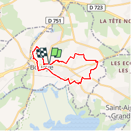
Tocht Stappen van 11,7 km beschikbaar op Pays de la Loire, Loire-Atlantique, Bouaye. Deze tocht wordt voorgesteld door jylera.
Beschrijving
Parking place G. Ricaud
Vignes de Gamay. Maison basses aux toits de tuiles. Voir topo guide Nantes Métropole à pied
Plaatsbepaling
Land:
France
Regio :
Pays de la Loire
Departement/Provincie :
Loire-Atlantique
Gemeente :
Bouaye
Locatie:
Unknown
Vertrek:(Dec)
Vertrek:(UTM)
599584 ; 5222009 (30T) N.
Opmerkingen
Wandeltochten in de omgeving
![Tocht Paard Bouaye - pouvreau surchaud - Photo](https://media.geolcdn.com/t/375/260/ext.jpg?maxdim=2&url=https%3A%2F%2Fstatic1.geolcdn.com%2Fsiteimages%2Fupload%2Ffiles%2F1524743154cheval.jpg)
![Paard Paard](https://static1.geolcdn.com/sitytour/trail-icons/300.png)
pouvreau surchaud
Paard
Gemakkelijk
(1)
Bouaye,
Pays de la Loire,
Loire-Atlantique,
France
![](/images/other/stat-length.png)
27 km | 29 km-effort
3h 57min
![](https://static1.geolcdn.com/siteimages/upload/files/16400158638029165_repeat_loop_refresh_sync_direction_icon.png)
Ja
![Tocht Te voet Saint-Mars-de-Coutais - Les Landas - Photo](https://media.geolcdn.com/t/375/260/cc8bcb90-39c4-4580-8ca7-9e86e87822c7.jpeg&format=jpg&maxdim=2)
![Te voet Te voet](https://static1.geolcdn.com/sitytour/trail-icons/100.png)
Les Landas
Te voet
Gemakkelijk
Saint-Mars-de-Coutais,
Pays de la Loire,
Loire-Atlantique,
France
![](/images/other/stat-length.png)
8,4 km | 8,9 km-effort
2h 1min
![](https://static1.geolcdn.com/siteimages/upload/files/16400158638029165_repeat_loop_refresh_sync_direction_icon.png)
Ja
![Tocht Te voet Bouguenais - La Roche Ballue - Photo](https://media.geolcdn.com/t/375/260/fe978ca7-737c-4da3-b5a6-561be870154c.jpeg&format=jpg&maxdim=2)
![Te voet Te voet](https://static1.geolcdn.com/sitytour/trail-icons/100.png)
La Roche Ballue
Te voet
Gemakkelijk
Bouguenais,
Pays de la Loire,
Loire-Atlantique,
France
![](/images/other/stat-length.png)
10,7 km | 12,2 km-effort
2h 47min
![](https://static1.geolcdn.com/siteimages/upload/files/16400158638029165_repeat_loop_refresh_sync_direction_icon.png)
Ja
![Tocht Stappen Saint-Aignan-Grandlieu - Saint-Aignan, aéroport, départ 18 rue du Champ de Foire - Photo](https://media.geolcdn.com/t/375/260/ext.jpg?maxdim=2&url=https%3A%2F%2Fstatic1.geolcdn.com%2Fsiteimages%2Fupload%2Ffiles%2F1553511878bg_sport_marche.png)
![Stappen Stappen](https://static1.geolcdn.com/sitytour/trail-icons/101.png)
Saint-Aignan, aéroport, départ 18 rue du Champ de Foire
Stappen
Medium
(1)
Saint-Aignan-Grandlieu,
Pays de la Loire,
Loire-Atlantique,
France
![](/images/other/stat-length.png)
8,8 km | 9,5 km-effort
2h 9min
![](https://static1.geolcdn.com/siteimages/upload/files/16400158638029165_repeat_loop_refresh_sync_direction_icon.png)
Ja
![Tocht Stappen Saint-Aignan-Grandlieu - Circuit des Halbrans - Photo](https://media.geolcdn.com/t/375/260/f4d5e9d5-86e7-4df4-8c41-3af143f113bb.jpg&format=jpg&maxdim=2)
![Stappen Stappen](https://static1.geolcdn.com/sitytour/trail-icons/101.png)
Circuit des Halbrans
Stappen
Moeilijk
Saint-Aignan-Grandlieu,
Pays de la Loire,
Loire-Atlantique,
France
![](/images/other/stat-length.png)
17,9 km | 19,3 km-effort
4h 16min
![](https://static1.geolcdn.com/siteimages/upload/files/16400158638029165_repeat_loop_refresh_sync_direction_icon.png)
Ja
![Tocht Stappen Bouaye - Bouaye, parc de la Mévellière, départ parking de Lidl - Photo](https://media.geolcdn.com/t/375/260/ext.jpg?maxdim=2&url=https%3A%2F%2Fstatic1.geolcdn.com%2Fsiteimages%2Fupload%2Ffiles%2F1553511878bg_sport_marche.png)
![Stappen Stappen](https://static1.geolcdn.com/sitytour/trail-icons/101.png)
Bouaye, parc de la Mévellière, départ parking de Lidl
Stappen
Gemakkelijk
Bouaye,
Pays de la Loire,
Loire-Atlantique,
France
![](/images/other/stat-length.png)
11,3 km | 12,3 km-effort
3h 22min
![](https://static1.geolcdn.com/siteimages/upload/files/16400158638029165_repeat_loop_refresh_sync_direction_icon.png)
Ja
![Tocht Mountainbike La Montagne - La Montagne, Bouguenais, St.Jean de Boiseau, Le Pellerin - Photo](https://media.geolcdn.com/t/375/260/ext.jpg?maxdim=2&url=https%3A%2F%2Fstatic1.geolcdn.com%2Fsiteimages%2Fupload%2Ffiles%2F1524743154velo.jpg)
![Mountainbike Mountainbike](https://static1.geolcdn.com/sitytour/trail-icons/202.png)
La Montagne, Bouguenais, St.Jean de Boiseau, Le Pellerin
Mountainbike
Medium
La Montagne,
Pays de la Loire,
Loire-Atlantique,
France
![](/images/other/stat-length.png)
50 km | 57 km-effort
3h 5min
![](https://static1.geolcdn.com/siteimages/upload/files/16400158638029165_repeat_loop_refresh_sync_direction_icon.png)
Ja
![Tocht Mountainbike Bouaye - SityTrail - 8339175-Tour du Lac 51km été - Photo](https://media.geolcdn.com/t/375/260/ext.jpg?maxdim=2&url=https%3A%2F%2Fstatic1.geolcdn.com%2Fsiteimages%2Fupload%2Ffiles%2F1524743154velo.jpg)
![Mountainbike Mountainbike](https://static1.geolcdn.com/sitytour/trail-icons/202.png)
SityTrail - 8339175-Tour du Lac 51km été
Mountainbike
Zeer moeilijk
Bouaye,
Pays de la Loire,
Loire-Atlantique,
France
![](/images/other/stat-length.png)
51 km | 55 km-effort
3h 48min
![](https://static1.geolcdn.com/siteimages/upload/files/16400158638029165_repeat_loop_refresh_sync_direction_icon.png)
Ja
![Tocht Stappen Bouguenais - La Roche Ballue - Photo](https://media.geolcdn.com/t/375/260/ext.jpg?maxdim=2&url=https%3A%2F%2Fstatic1.geolcdn.com%2Fsiteimages%2Fupload%2Ffiles%2F1553511878bg_sport_marche.png)
![Stappen Stappen](https://static1.geolcdn.com/sitytour/trail-icons/101.png)
La Roche Ballue
Stappen
Gemakkelijk
Bouguenais,
Pays de la Loire,
Loire-Atlantique,
France
![](/images/other/stat-length.png)
13,3 km | 15,2 km-effort
2h 46min
![](https://static1.geolcdn.com/siteimages/upload/files/16400158638029165_repeat_loop_refresh_sync_direction_icon.png)
Ja