![](/images/other/stat-length.png)
![Tocht Stappen Auribeau - Mourre Nègre depuis Auribeau - Photo](https://media.geolcdn.com/t/1900/400/ext.pjpeg?maxdim=2&url=https%3A%2F%2Fstatic1.geolcdn.com%2Fsiteimages%2Fupload%2Ffiles%2F1553511878bg_sport_marche.png)
Mourre Nègre depuis Auribeau
jmheydorff
Gebruiker
![Lengte](/images/other/stat-length.png)
![Max. hoogte](https://static1.geolcdn.com/siteimages/upload/files/1508320355ic_sort_altitude_max_24dp.png)
![Positief hoogteverschil](https://static1.geolcdn.com/siteimages/upload/files/1508320355ic_sort_den_pos_24dp.png)
![Km-Effort](/images/other/stat-length.png)
![Min. hoogte](https://static1.geolcdn.com/siteimages/upload/files/1508320355ic_sort_altitude_min_24dp.png)
![Negatief hoogteverschil](https://static1.geolcdn.com/siteimages/upload/files/1508320355ic_sort_den_neg_24dp.png)
![Boucle](https://static1.geolcdn.com/siteimages/upload/files/16400158638029165_repeat_loop_refresh_sync_direction_icon.png)
![Stappen](https://static1.geolcdn.com/sitytour/trail-icons/101.png)
--
Moeilijkheid : Medium
![Scan deze QR-code om de tocht te openen in de SityTrail-applicatie](https://capi.geolives.com/qq0zvz2zws4bq2lad0pu/sitytour/trails/157750/qr.png?size=200)
Gratisgps-wandelapplicatie
Over ons
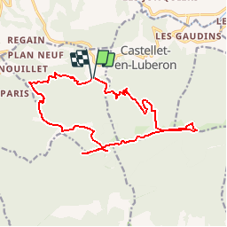
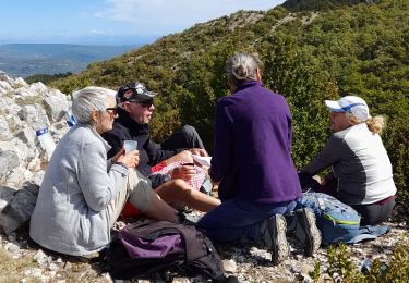
Tocht Stappen van 18,1 km beschikbaar op Provence-Alpes-Côte d'Azur, Vaucluse, Auribeau. Deze tocht wordt voorgesteld door jmheydorff.
Beschrijving
Pkg Auribeau, à l'extrémité Sud (alt. 600m), dans un virage, drerière un bosquet.
Monter SE et traverser plusieurs vallons sur de petits sentiers, jusqu'aux ruines de Agranier.
On rejoint alors la piste de crête (GR9-92) du Mourre Nègre (1061m); on peut faire un AR vers l'Est sur la ligne de crête (bordure Sud); on revient et on continue la crête en W, après le Mourre nègre (1125m), jusqu'à son extrémité (1041m); on rattrappe au N la piste, et l'on descend le GR jusqu'à la cote 650, où l'on prend un large sentier E ; on traverse lle vallon de la Femme Morte, pour aller visiter la chapelle St Pierre, et rejoindre le pkg
Plaatsbepaling
Opmerkingen
Wandeltochten in de omgeving
![Tocht Stappen Saignon - Saignon Bories - Photo](https://media.geolcdn.com/t/375/260/ext.jpg?maxdim=2&url=https%3A%2F%2Fservices.sitytrail.com%2FGeolivesWS%2FDownloadMedia.ashx%3FTrailID%3D875086%26Media%3Dfix__20171213141855.jpg)
![Stappen Stappen](https://static1.geolcdn.com/sitytour/trail-icons/101.png)
Stappen
![](/images/other/stat-length.png)
![](https://static1.geolcdn.com/siteimages/upload/files/16400158638029165_repeat_loop_refresh_sync_direction_icon.png)
![Tocht Stappen Buoux - Plateau des Claparèdes - Saignon - Photo](https://media.geolcdn.com/t/375/260/ext.jpg?maxdim=2&url=https%3A%2F%2Fservices.sitytrail.com%2FGeolivesWS%2FDownloadMedia.ashx%3FTrailID%3D172671%26Media%3D14050_6.jpg)
![Stappen Stappen](https://static1.geolcdn.com/sitytour/trail-icons/101.png)
Stappen
![](/images/other/stat-length.png)
![](https://static1.geolcdn.com/siteimages/upload/files/16400158638029165_repeat_loop_refresh_sync_direction_icon.png)
![Tocht Stappen Sivergues - Sivergues - Photo](https://media.geolcdn.com/t/375/260/cd7c60b1-2083-42a3-bc5d-7e7748add702.jpg&format=jpg&maxdim=2)
![Stappen Stappen](https://static1.geolcdn.com/sitytour/trail-icons/101.png)
Stappen
![](/images/other/stat-length.png)
![](https://static1.geolcdn.com/siteimages/upload/files/16400158638029165_repeat_loop_refresh_sync_direction_icon.png)
![Tocht Fiets Saint-Martin-de-Castillon - La Véloroute - Voie Verte du Calavon - Photo](https://media.geolcdn.com/t/375/260/ext.jpg?maxdim=2&url=https%3A%2F%2Fservices.sitytrail.com%2FGeolivesWS%2FDownloadMedia.ashx%3FTrailID%3D375432%26Media%3D492bf258-2a21-4a95-9687-f1dbf28d9a2a.jpg)
![Fiets Fiets](https://static1.geolcdn.com/sitytour/trail-icons/200.png)
Fiets
![](/images/other/stat-length.png)
![](https://static1.geolcdn.com/siteimages/upload/files/16400158638029165_repeat_loop_refresh_sync_direction_icon.png)
![Tocht Stappen Auribeau - Le Mourre Nègre - Photo](https://media.geolcdn.com/t/375/260/ext.jpg?maxdim=2&url=https%3A%2F%2Fstatic1.geolcdn.com%2Fsiteimages%2Fupload%2Ffiles%2F1553511878bg_sport_marche.png)
![Stappen Stappen](https://static1.geolcdn.com/sitytour/trail-icons/101.png)
Stappen
![](/images/other/stat-length.png)
![](https://static1.geolcdn.com/siteimages/upload/files/16400158638029165_repeat_loop_refresh_sync_direction_icon.png)
![Tocht Stappen Buoux - Buoux /Saignon - Photo](https://media.geolcdn.com/t/375/260/8016e237-e898-4498-92fa-2ffc400227b2.jpg&format=jpg&maxdim=2)
![Stappen Stappen](https://static1.geolcdn.com/sitytour/trail-icons/101.png)
Stappen
![](/images/other/stat-length.png)
![](https://static1.geolcdn.com/siteimages/upload/files/16400158638029165_repeat_loop_refresh_sync_direction_icon.png)
![Tocht Stappen Sivergues - SIVERGUES / AIGUE BRUN - Photo](https://media.geolcdn.com/t/375/260/e538e4b5-c2d7-4e8e-b0c3-72bf8b9a3045.jpg&format=jpg&maxdim=2)
![Stappen Stappen](https://static1.geolcdn.com/sitytour/trail-icons/101.png)
Stappen
![](/images/other/stat-length.png)
![](https://static1.geolcdn.com/siteimages/upload/files/16400158638029165_repeat_loop_refresh_sync_direction_icon.png)
![Tocht Stappen Auribeau - Auribeau Mourre Négre retour Auribeau - Photo](https://media.geolcdn.com/t/375/260/a5950379-bfff-488c-9748-ecf51b9bfe23.jpg&format=jpg&maxdim=2)
![Stappen Stappen](https://static1.geolcdn.com/sitytour/trail-icons/101.png)
Stappen
![](/images/other/stat-length.png)
![](https://static1.geolcdn.com/siteimages/upload/files/16400158638029165_repeat_loop_refresh_sync_direction_icon.png)
![Tocht Stappen Apt - CR_Domitia_BE_25_Apt_Cereste_20220407 - Photo](https://media.geolcdn.com/t/375/260/e031bc88-d5c7-4a4a-9824-4c761c5d5cf3.jpg&format=jpg&maxdim=2)
![Stappen Stappen](https://static1.geolcdn.com/sitytour/trail-icons/101.png)
Stappen
![](/images/other/stat-length.png)
![](https://static1.geolcdn.com/siteimages/upload/files/16400158638029165_repeat_loop_refresh_sync_direction_icon.png)