![](/images/other/stat-length.png)
![Tocht Stappen Sewen - SEWEN-GRAND LANGENFELD - Photo](https://media.geolcdn.com/t/1900/400/ext.pjpeg?maxdim=2&url=https%3A%2F%2Fstatic1.geolcdn.com%2Fsiteimages%2Fupload%2Ffiles%2F1553511878bg_sport_marche.png)
SEWEN-GRAND LANGENFELD
patrickbeyrath
Gebruiker
![Lengte](/images/other/stat-length.png)
Lengte
8,6 km
![Max. hoogte](https://static1.geolcdn.com/siteimages/upload/files/1508320355ic_sort_altitude_max_24dp.png)
Max. hoogte
970 m
![Positief hoogteverschil](https://static1.geolcdn.com/siteimages/upload/files/1508320355ic_sort_den_pos_24dp.png)
Positief hoogteverschil
468 m
![Km-Effort](/images/other/stat-length.png)
Km-Effort
14,9 km
![Min. hoogte](https://static1.geolcdn.com/siteimages/upload/files/1508320355ic_sort_altitude_min_24dp.png)
Min. hoogte
512 m
![Negatief hoogteverschil](https://static1.geolcdn.com/siteimages/upload/files/1508320355ic_sort_den_neg_24dp.png)
Negatief hoogteverschil
467 m
![Boucle](https://static1.geolcdn.com/siteimages/upload/files/16400158638029165_repeat_loop_refresh_sync_direction_icon.png)
Boucle
Ja
Datum van aanmaak :
2018-10-13 05:53:35.109
Laatste wijziging :
2018-10-13 05:53:35.117
![Stappen](https://static1.geolcdn.com/sitytour/trail-icons/101.png)
--
Moeilijkheid : Medium
![Scan deze QR-code om de tocht te openen in de SityTrail-applicatie](https://capi.geolives.com/qq0zvz2zws4bq2lad0pu/sitytour/trails/157695/qr.png?size=200)
Gratisgps-wandelapplicatie
Over ons
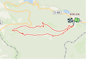
Tocht Stappen van 8,6 km beschikbaar op Grand Est, Haut-Rhin, Sewen. Deze tocht wordt voorgesteld door patrickbeyrath.
Beschrijving
Départ Parking centrale micro électrique de SEWEN-X rouge direction ferme du petit Langenberg et le petit Langenberg et ensuite direction ferme du Grand Langenberg Triangle rouge et poursuivre vers Lerschenmatt et prendre GR531 retour centrale micro électrique
Plaatsbepaling
Land:
France
Regio :
Grand Est
Departement/Provincie :
Haut-Rhin
Gemeente :
Sewen
Locatie:
Unknown
Vertrek:(Dec)
Vertrek:(UTM)
342946 ; 5296791 (32T) N.
Opmerkingen
Wandeltochten in de omgeving
![Tocht Stappen Rimbach-près-Masevaux - Haute Bers - Photo](https://media.geolcdn.com/t/375/260/263a149f-9c7c-4184-802a-631c78ca66f6.jpg&format=jpg&maxdim=2)
![Stappen Stappen](https://static1.geolcdn.com/sitytour/trail-icons/101.png)
Haute Bers
Stappen
Medium
(1)
Rimbach-près-Masevaux,
Grand Est,
Haut-Rhin,
France
![](/images/other/stat-length.png)
12 km | 20 km-effort
3h 25min
![](https://static1.geolcdn.com/siteimages/upload/files/16400158638029165_repeat_loop_refresh_sync_direction_icon.png)
Ja
![Tocht Stappen Saint-Maurice-sur-Moselle - Tour du Ballon d'Alsace - Photo](https://media.geolcdn.com/t/375/260/ext.jpg?maxdim=2&url=https%3A%2F%2Fservices.sitytrail.com%2FGeolivesWS%2FDownloadMedia.ashx%3FTrailID%3D450011%26Media%3Dfix__20150716161020.jpg)
![Stappen Stappen](https://static1.geolcdn.com/sitytour/trail-icons/101.png)
Tour du Ballon d'Alsace
Stappen
Moeilijk
(1)
Saint-Maurice-sur-Moselle,
Grand Est,
Vogezen,
France
![](/images/other/stat-length.png)
10,5 km | 17,7 km-effort
5h 25min
![](https://static1.geolcdn.com/siteimages/upload/files/16400158638029165_repeat_loop_refresh_sync_direction_icon.png)
Ja
![Tocht Stappen Sewen - Boucle entre les lacs de Sewen et d'Alfeld - Photo](https://media.geolcdn.com/t/375/260/ext.jpg?maxdim=2&url=https%3A%2F%2Fservices.sitytrail.com%2FGeolivesWS%2FDownloadMedia.ashx%3FTrailID%3D103686%26Media%3D6168_4.jpg)
![Stappen Stappen](https://static1.geolcdn.com/sitytour/trail-icons/101.png)
Boucle entre les lacs de Sewen et d'Alfeld
Stappen
Medium
(1)
Sewen,
Grand Est,
Haut-Rhin,
France
![](/images/other/stat-length.png)
8,1 km | 12,3 km-effort
2h 30min
![](https://static1.geolcdn.com/siteimages/upload/files/16400158638029165_repeat_loop_refresh_sync_direction_icon.png)
Ja
![Tocht Stappen Sewen - lac d'Alfeld - Photo](https://media.geolcdn.com/t/375/260/f10be3b8-650f-4f78-b860-6c956e66a815.jpg&format=jpg&maxdim=2)
![Stappen Stappen](https://static1.geolcdn.com/sitytour/trail-icons/101.png)
lac d'Alfeld
Stappen
Zeer moeilijk
(1)
Sewen,
Grand Est,
Haut-Rhin,
France
![](/images/other/stat-length.png)
17,1 km | 28 km-effort
8h 7min
![](https://static1.geolcdn.com/siteimages/upload/files/16400158638029165_repeat_loop_refresh_sync_direction_icon.png)
Ja
![Tocht Stappen Dolleren - 2025-01-03 Rando Polaire Dolleren Ballon Alsace Etape 2 - Photo](https://media.geolcdn.com/t/375/260/9acfce3f-2eaf-4a63-8eb3-62065bd107c3.jpg&format=jpg&maxdim=2)
![Stappen Stappen](https://static1.geolcdn.com/sitytour/trail-icons/101.png)
2025-01-03 Rando Polaire Dolleren Ballon Alsace Etape 2
Stappen
Zeer moeilijk
Dolleren,
Grand Est,
Haut-Rhin,
France
![](/images/other/stat-length.png)
17,3 km | 26 km-effort
6h 0min
![](https://static1.geolcdn.com/siteimages/upload/files/16400158638029165_repeat_loop_refresh_sync_direction_icon.png)
Neen
![Tocht Stappen Dolleren - suuntoapp-Hiking-2025-01-02T19-20-24Z - Photo](https://media.geolcdn.com/t/375/260/98b6c1e4-75f0-464a-86a1-edc427e75210.jpg&format=jpg&maxdim=2)
![Stappen Stappen](https://static1.geolcdn.com/sitytour/trail-icons/101.png)
suuntoapp-Hiking-2025-01-02T19-20-24Z
Stappen
Medium
Dolleren,
Grand Est,
Haut-Rhin,
France
![](/images/other/stat-length.png)
4,3 km | 8,1 km-effort
1h 50min
![](https://static1.geolcdn.com/siteimages/upload/files/16400158638029165_repeat_loop_refresh_sync_direction_icon.png)
Neen
![Tocht Stappen Kirchberg - 2022-07-15 Marche Refuge Baerenkopf Auberge Gazon Vert - Photo](https://media.geolcdn.com/t/375/260/d5c191fc-95a3-4bb1-8368-e694339cee76.jpg&format=jpg&maxdim=2)
![Stappen Stappen](https://static1.geolcdn.com/sitytour/trail-icons/101.png)
2022-07-15 Marche Refuge Baerenkopf Auberge Gazon Vert
Stappen
Zeer moeilijk
Kirchberg,
Grand Est,
Haut-Rhin,
France
![](/images/other/stat-length.png)
23 km | 38 km-effort
8h 21min
![](https://static1.geolcdn.com/siteimages/upload/files/16400158638029165_repeat_loop_refresh_sync_direction_icon.png)
Neen
![Tocht Stappen Rimbach-près-Masevaux - Les deux lacs - Photo](https://media.geolcdn.com/t/375/260/ec102df6-1fd0-42bb-8bbd-9523bd80f1a9.jpg&format=jpg&maxdim=2)
![Stappen Stappen](https://static1.geolcdn.com/sitytour/trail-icons/101.png)
Les deux lacs
Stappen
Moeilijk
Rimbach-près-Masevaux,
Grand Est,
Haut-Rhin,
France
![](/images/other/stat-length.png)
15,5 km | 25 km-effort
5h 47min
![](https://static1.geolcdn.com/siteimages/upload/files/16400158638029165_repeat_loop_refresh_sync_direction_icon.png)
Ja
![Tocht Stappen Masevaux-Niederbruck - Rando CLAS du 25/04/2024 - Photo](https://media.geolcdn.com/t/375/260/7819aa97-a355-4a49-a02f-f265b4ed9c29.jpg&format=jpg&maxdim=2)
![Stappen Stappen](https://static1.geolcdn.com/sitytour/trail-icons/101.png)
Rando CLAS du 25/04/2024
Stappen
Zeer moeilijk
Masevaux-Niederbruck,
Grand Est,
Haut-Rhin,
France
![](/images/other/stat-length.png)
17 km | 28 km-effort
4h 24min
![](https://static1.geolcdn.com/siteimages/upload/files/16400158638029165_repeat_loop_refresh_sync_direction_icon.png)
Ja