Tocht Sneeuwschoenen Formiguères - Formigueres Espousouille Fontrabiouse - Photo

Formigueres Espousouille Fontrabiouse

 xav34830
xav34830

Gebruiker

© OpenStreetMap contributors
Lengte
Lengte
12,6 km
Max. hoogte
Max. hoogte
1657 m
Positief hoogteverschil
432 m
Km-Effort
Km-Effort  
18,4 km
Min. hoogte
Min. hoogte
1492 m
Negatief hoogteverschil
432 m
Boucle
Boucle
Ja
Datum van aanmaak :
2014-12-10 00:00:00.0
Laatste wijziging :
2014-12-10 00:00:00.0

(0 Bericht)

Sneeuwschoenen
Sneeuwschoenen
--
Moeilijkheid : Medium

Scan deze QR-code om de tocht te openen in de SityTrail-applicatie

Gratisgps-wandelapplicatie

Logo SityTrail SityTrail

IGN / Geografische instituten

SityTrail uit de App Store downloaden SityTrail uit Google Play downloaden

Logo SityTrail SityTrail World

De wereld gaat voor u open

SityTrail uit de App Store downloaden SityTrail uit Google Play downloaden SityTrail op Huawei AppGallery downloaden

Over ons

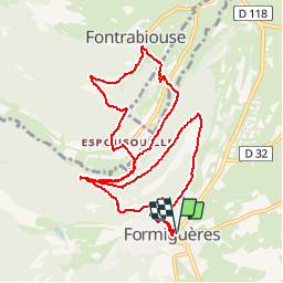
Tocht Sneeuwschoenen van 12,6 km beschikbaar op Occitanië, Pyrénées-Orientales, Formiguères. Deze tocht wordt voorgesteld door xav34830.

Beschrijving

Excursion relativamente tranquila para ir desde Formigueres a Espousouille y a Fontrabiouse, subiendo y bajando las 2 montañas que separan estos 3 pueblos, tal como vemos en el track y en el perfil de la ruta.

Ver detalles de la excursion y fotos en nuestro blog

Hoogteprofiel

POI's

POI Fontrabiouse - Espousouille - Photo
xav34830
FONTRABIOUSE 
POI Fontrabiouse - Fontrabiouse - Photo
xav34830
FONTRABIOUSE 
POI Fontrabiouse - Grutas - Photo
xav34830
FONTRABIOUSE 
POI Formiguères - L'Agores - Photo
xav34830
FORMIGUÈRES 
POI Formiguères - Salida - Photo
xav34830
FORMIGUÈRES 

Plaatsbepaling

Land:
France
Regio :
Occitanië
Departement/Provincie :
Pyrénées-Orientales
Gemeente :
Formiguères
Locatie:
Unknown
Vertrek:(Dec)
Vertrek:(UTM)
426491 ; 4718353 (31T) N.

Wandeltochten in de omgeving

Tocht Sneeuwschoenen Réal - madres - Photo
Sneeuwschoenen
mongo

Sneeuwschoenen

Moeilijk
(1)
Réal, Occitanië, Pyrénées-Orientales, France
13,1 km | 26 km-effort
6h 48min
Ja
Tocht Stappen Les Angles - les Angles - Photo
Stappen
GUIDE
nadinebondoux

Stappen

Moeilijk
Les Angles, Occitanië, Pyrénées-Orientales, France
14,5 km | 20 km-effort
4h 58min
Neen
Tocht Stappen Formiguères - Les Camporells par la Lladure  - Photo
Stappen
jcmartin

Stappen

Medium
(1)
Formiguères, Occitanië, Pyrénées-Orientales, France
15,1 km | 24 km-effort
5h 7min
Ja
Tocht Stappen Les Angles - boucle de la Balmette par le mont Llaret et le roc d'aude - Photo
Stappen
Axelloceane

Stappen

Medium
(2)
Les Angles, Occitanië, Pyrénées-Orientales, France
17,2 km | 28 km-effort
Onbekend
Ja
Tocht sport Formiguères - 20240728 Station Formiguères - Camporeils - Photo
sport
ThonyM

sport

Heel gemakkelijk
Formiguères, Occitanië, Pyrénées-Orientales, France
16 km | 27 km-effort
Onbekend
Ja
Tocht Stappen Puyvalador - Puyvalador tour du lac  - Photo
Stappen
GUIDE
antignacs

Stappen

Heel gemakkelijk
Puyvalador, Occitanië, Pyrénées-Orientales, France
12,1 km | 15,9 km-effort
3h 39min
Ja
Tocht Stappen Formiguères - 20210819 Porteille d’Orlu, étang du diable - Photo
Stappen
ThonyM

Stappen

Moeilijk
Formiguères, Occitanië, Pyrénées-Orientales, France
16,4 km | 29 km-effort
5h 3min
Ja
Tocht Stappen Formiguères - 20210710 pla del bosc - Foumigueres - Photo
Stappen
ThonyM

Stappen

Gemakkelijk
Formiguères, Occitanië, Pyrénées-Orientales, France
12,5 km | 18,3 km-effort
2h 47min
Ja
Tocht Sneeuwschoenen Les Angles - 2021-02-11 Sortie CAF - Les Angles - vers les Camporells - Photo
Sneeuwschoenen
eric.mignot

Sneeuwschoenen

Medium
Les Angles, Occitanië, Pyrénées-Orientales, France
16,8 km | 24 km-effort
7h 0min
Ja


Sluiten
Mijn abonnementen