![](/images/other/stat-length.png)
![Tocht Stappen Tharaux - Gorges de la Cèze: Rando aquatique - Photo](https://media.geolcdn.com/t/1900/400/ext.pjpeg?maxdim=2&url=https%3A%2F%2Fstatic1.geolcdn.com%2Fsiteimages%2Fupload%2Ffiles%2F1553511878bg_sport_marche.png)
Gorges de la Cèze: Rando aquatique
jmheydorff
Gebruiker
![Lengte](/images/other/stat-length.png)
Lengte
17,6 km
![Max. hoogte](https://static1.geolcdn.com/siteimages/upload/files/1508320355ic_sort_altitude_max_24dp.png)
Max. hoogte
306 m
![Positief hoogteverschil](https://static1.geolcdn.com/siteimages/upload/files/1508320355ic_sort_den_pos_24dp.png)
Positief hoogteverschil
570 m
![Km-Effort](/images/other/stat-length.png)
Km-Effort
25 km
![Min. hoogte](https://static1.geolcdn.com/siteimages/upload/files/1508320355ic_sort_altitude_min_24dp.png)
Min. hoogte
94 m
![Negatief hoogteverschil](https://static1.geolcdn.com/siteimages/upload/files/1508320355ic_sort_den_neg_24dp.png)
Negatief hoogteverschil
398 m
![Boucle](https://static1.geolcdn.com/siteimages/upload/files/16400158638029165_repeat_loop_refresh_sync_direction_icon.png)
Boucle
Neen
Datum van aanmaak :
2014-12-10 00:00:00.0
Laatste wijziging :
2014-12-10 00:00:00.0
![Stappen](https://static1.geolcdn.com/sitytour/trail-icons/101.png)
6h00
Moeilijkheid : Medium
![Scan deze QR-code om de tocht te openen in de SityTrail-applicatie](https://capi.geolives.com/qq0zvz2zws4bq2lad0pu/sitytour/trails/151482/qr.png?size=200)
Gratisgps-wandelapplicatie
Over ons
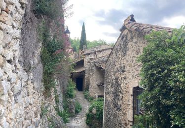
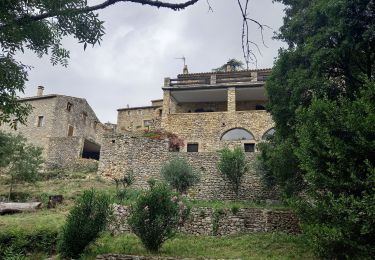
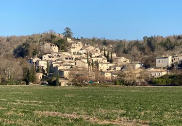
Tocht Stappen van 17,6 km beschikbaar op Occitanië, Gard, Tharaux. Deze tocht wordt voorgesteld door jmheydorff.
Beschrijving
Pkg cimetière de Tharaux.une voiture à mettre à Le Clap, pour le retour.
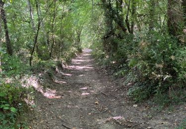
Descente des gorges de la Cèze, de Tharaux au Ranc du Chabrier, en traversant 8 fois la Rivière Cèze.
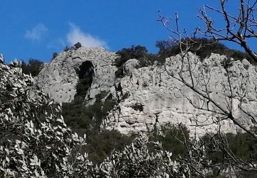
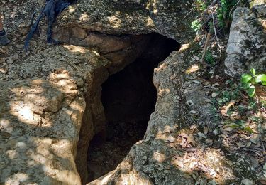
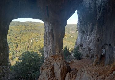
Puis on monte dans le bois des Banquières, voir la baume des Fades (Domen), l'aven de Carquignau
Plaatsbepaling
Land:
France
Regio :
Occitanië
Departement/Provincie :
Gard
Gemeente :
Tharaux
Locatie:
Unknown
Vertrek:(Dec)
Vertrek:(UTM)
604565 ; 4899524 (31T) N.
Opmerkingen
Wandeltochten in de omgeving
![Tocht Stappen Allègre-les-Fumades - château d allègre aiguieres - Photo](https://media.geolcdn.com/t/375/260/c7f87895-b1c3-467b-937c-ecf963f10da2.jpg&format=jpg&maxdim=2)
![Stappen Stappen](https://static1.geolcdn.com/sitytour/trail-icons/101.png)
château d allègre aiguieres
Stappen
Medium
(1)
Allègre-les-Fumades,
Occitanië,
Gard,
France
![](/images/other/stat-length.png)
16,9 km | 25 km-effort
6h 10min
![](https://static1.geolcdn.com/siteimages/upload/files/16400158638029165_repeat_loop_refresh_sync_direction_icon.png)
Ja
![Tocht Stappen Saint-Privat-de-Champclos - Château de Ferreyrolle - Photo](https://media.geolcdn.com/t/375/260/6d35cd9d-375d-4f33-83e5-2813e967a743.jpg&format=jpg&maxdim=2)
![Stappen Stappen](https://static1.geolcdn.com/sitytour/trail-icons/101.png)
Château de Ferreyrolle
Stappen
Medium
Saint-Privat-de-Champclos,
Occitanië,
Gard,
France
![](/images/other/stat-length.png)
16,9 km | 24 km-effort
6h 8min
![](https://static1.geolcdn.com/siteimages/upload/files/16400158638029165_repeat_loop_refresh_sync_direction_icon.png)
Ja
![Tocht Stappen Tharaux - Tharaux - Photo](https://media.geolcdn.com/t/375/260/01bc6044-7c62-4cc1-8831-f55311bb9329.jpg&format=jpg&maxdim=2)
![Stappen Stappen](https://static1.geolcdn.com/sitytour/trail-icons/101.png)
![Tocht Stappen Rochegude - ROCHEGUDE - GROTTE DES CAMISARDS - Photo](https://media.geolcdn.com/t/375/260/16497b10-8ac8-49c4-9447-7778ef028cc3.jpeg&format=jpg&maxdim=2)
![Stappen Stappen](https://static1.geolcdn.com/sitytour/trail-icons/101.png)
ROCHEGUDE - GROTTE DES CAMISARDS
Stappen
Medium
Rochegude,
Occitanië,
Gard,
France
![](/images/other/stat-length.png)
5 km | 7,6 km-effort
1h 43min
![](https://static1.geolcdn.com/siteimages/upload/files/16400158638029165_repeat_loop_refresh_sync_direction_icon.png)
Ja
![Tocht Stappen Rivières - 231203_Rivières - Photo](https://media.geolcdn.com/t/375/260/90c703ff-22cb-4a53-ba01-e199fc09b073.jpg&format=jpg&maxdim=2)
![Stappen Stappen](https://static1.geolcdn.com/sitytour/trail-icons/101.png)
231203_Rivières
Stappen
Moeilijk
Rivières,
Occitanië,
Gard,
France
![](/images/other/stat-length.png)
15,4 km | 18,9 km-effort
5h 43min
![](https://static1.geolcdn.com/siteimages/upload/files/16400158638029165_repeat_loop_refresh_sync_direction_icon.png)
Ja
![Tocht Stappen Tharaux - Tharaux la Cèze - Photo](https://media.geolcdn.com/t/375/260/4bdb970c-b0f9-4e30-b3b2-4f135c4250be.jpg&format=jpg&maxdim=2)
![Stappen Stappen](https://static1.geolcdn.com/sitytour/trail-icons/101.png)
![Tocht Stappen Méjannes-le-Clap - mejannes le clap - Photo](https://media.geolcdn.com/t/375/260/d0e23ebe-33e3-4300-84fa-90d302ddb272.jpg&format=jpg&maxdim=2)
![Stappen Stappen](https://static1.geolcdn.com/sitytour/trail-icons/101.png)
mejannes le clap
Stappen
Medium
Méjannes-le-Clap,
Occitanië,
Gard,
France
![](/images/other/stat-length.png)
14,4 km | 19,3 km-effort
5h 19min
![](https://static1.geolcdn.com/siteimages/upload/files/16400158638029165_repeat_loop_refresh_sync_direction_icon.png)
Ja
![Tocht Stappen Rochegude - Rochegude 30 - Photo](https://media.geolcdn.com/t/375/260/a538ea29-ca1c-4e49-a5d0-6fa2d1fad284.jpg&format=jpg&maxdim=2)
![Stappen Stappen](https://static1.geolcdn.com/sitytour/trail-icons/101.png)
![Tocht Stappen Méjannes-le-Clap - Mejannes le clap par Rocher de l'Aigle - Photo](https://media.geolcdn.com/t/375/260/71c29605-58ee-4bb6-9602-558b471b1323.jpg&format=jpg&maxdim=2)
![Stappen Stappen](https://static1.geolcdn.com/sitytour/trail-icons/101.png)
Mejannes le clap par Rocher de l'Aigle
Stappen
Moeilijk
Méjannes-le-Clap,
Occitanië,
Gard,
France
![](/images/other/stat-length.png)
15,3 km | 21 km-effort
5h 14min
![](https://static1.geolcdn.com/siteimages/upload/files/16400158638029165_repeat_loop_refresh_sync_direction_icon.png)
Ja
nul le serveur de carte n'est jamais accessible et le gps perd lá trace même en paramétrage de situation approximative, alors qu'avec d'autres logiciels sur le même appareil tout fonctionne correctement.