![](/images/other/stat-length.png)
![Tocht Mountainbike Senillé-Saint-Sauveur - Zevtt - Senillé 2012 - Photo](https://media.geolcdn.com/t/1900/400/ext.pjpeg?maxdim=2&url=https%3A%2F%2Fstatic1.geolcdn.com%2Fsiteimages%2Fupload%2Ffiles%2F1524743154velo.jpg)
Zevtt - Senillé 2012
kipoura
Gebruiker
![Lengte](/images/other/stat-length.png)
Lengte
51 km
![Max. hoogte](https://static1.geolcdn.com/siteimages/upload/files/1508320355ic_sort_altitude_max_24dp.png)
Max. hoogte
150 m
![Positief hoogteverschil](https://static1.geolcdn.com/siteimages/upload/files/1508320355ic_sort_den_pos_24dp.png)
Positief hoogteverschil
760 m
![Km-Effort](/images/other/stat-length.png)
Km-Effort
61 km
![Min. hoogte](https://static1.geolcdn.com/siteimages/upload/files/1508320355ic_sort_altitude_min_24dp.png)
Min. hoogte
61 m
![Negatief hoogteverschil](https://static1.geolcdn.com/siteimages/upload/files/1508320355ic_sort_den_neg_24dp.png)
Negatief hoogteverschil
760 m
![Boucle](https://static1.geolcdn.com/siteimages/upload/files/16400158638029165_repeat_loop_refresh_sync_direction_icon.png)
Boucle
Ja
Datum van aanmaak :
2019-05-03 17:10:28.792
Laatste wijziging :
2019-05-03 17:10:29.092
![Mountainbike](https://static1.geolcdn.com/sitytour/trail-icons/202.png)
--
Moeilijkheid : Moeilijk
![Scan deze QR-code om de tocht te openen in de SityTrail-applicatie](https://capi.geolives.com/qq0zvz2zws4bq2lad0pu/sitytour/trails/149972/qr.png?size=200)
Gratisgps-wandelapplicatie
Over ons
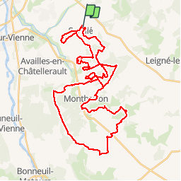
Tocht Mountainbike van 51 km beschikbaar op Nieuw-Aquitanië, Vienne, Senillé-Saint-Sauveur. Deze tocht wordt voorgesteld door kipoura.
Beschrijving
Un superbe parcours VTT d'une cinquantaine de kilomètres au départ de Senillé. Un cocktail de passage ludiques, techniques et physiques ... bonne condition physique souhaitable .....
Plaatsbepaling
Land:
France
Regio :
Nieuw-Aquitanië
Departement/Provincie :
Vienne
Gemeente :
Senillé-Saint-Sauveur
Locatie:
Senillé
Vertrek:(Dec)
Vertrek:(UTM)
318088 ; 5183650 (31T) N.
Opmerkingen
Wandeltochten in de omgeving
![Stappen Stappen](https://static1.geolcdn.com/sitytour/trail-icons/101.png)
Availles Chitré
Stappen
Medium
Availles-en-Châtellerault,
Nieuw-Aquitanië,
Vienne,
France
![](/images/other/stat-length.png)
6,2 km | 7,7 km-effort
1h 35min
![](https://static1.geolcdn.com/siteimages/upload/files/16400158638029165_repeat_loop_refresh_sync_direction_icon.png)
Ja
![Stappen Stappen](https://static1.geolcdn.com/sitytour/trail-icons/101.png)
Prinçay 4,2
Stappen
Availles-en-Châtellerault,
Nieuw-Aquitanië,
Vienne,
France
![](/images/other/stat-length.png)
4,6 km | 5,3 km-effort
1h 7min
![](https://static1.geolcdn.com/siteimages/upload/files/16400158638029165_repeat_loop_refresh_sync_direction_icon.png)
Ja
![Tocht Stappen Availles-en-Châtellerault - Availles-en-Châtellerault - les Fombeurs - Photo](https://media.geolcdn.com/t/375/260/ext.jpg?maxdim=2&url=https%3A%2F%2Fstatic1.geolcdn.com%2Fsiteimages%2Fupload%2Ffiles%2F1553511878bg_sport_marche.png)
![Stappen Stappen](https://static1.geolcdn.com/sitytour/trail-icons/101.png)
Availles-en-Châtellerault - les Fombeurs
Stappen
Medium
Availles-en-Châtellerault,
Nieuw-Aquitanië,
Vienne,
France
![](/images/other/stat-length.png)
8,2 km | 9,3 km-effort
2h 6min
![](https://static1.geolcdn.com/siteimages/upload/files/16400158638029165_repeat_loop_refresh_sync_direction_icon.png)
Ja
![Tocht Stappen Availles-en-Châtellerault - Availles en Châtellerault les Fontenelles - Photo](https://media.geolcdn.com/t/375/260/ext.jpg?maxdim=2&url=https%3A%2F%2Fstatic1.geolcdn.com%2Fsiteimages%2Fupload%2Ffiles%2F1553511878bg_sport_marche.png)
![Stappen Stappen](https://static1.geolcdn.com/sitytour/trail-icons/101.png)
Availles en Châtellerault les Fontenelles
Stappen
Medium
Availles-en-Châtellerault,
Nieuw-Aquitanië,
Vienne,
France
![](/images/other/stat-length.png)
8,2 km | 9,1 km-effort
2h 4min
![](https://static1.geolcdn.com/siteimages/upload/files/16400158638029165_repeat_loop_refresh_sync_direction_icon.png)
Ja
![Tocht Stappen Availles-en-Châtellerault - Availles-en-Châtellerault le Magnou - Photo](https://media.geolcdn.com/t/375/260/ext.jpg?maxdim=2&url=https%3A%2F%2Fstatic1.geolcdn.com%2Fsiteimages%2Fupload%2Ffiles%2F1553511878bg_sport_marche.png)
![Stappen Stappen](https://static1.geolcdn.com/sitytour/trail-icons/101.png)
Availles-en-Châtellerault le Magnou
Stappen
Gemakkelijk
Availles-en-Châtellerault,
Nieuw-Aquitanië,
Vienne,
France
![](/images/other/stat-length.png)
4,9 km | 5,3 km-effort
1h 12min
![](https://static1.geolcdn.com/siteimages/upload/files/16400158638029165_repeat_loop_refresh_sync_direction_icon.png)
Ja
![Tocht Stappen Availles-en-Châtellerault - Essai - Photo](https://media.geolcdn.com/t/375/260/ext.jpg?maxdim=2&url=https%3A%2F%2Fstatic1.geolcdn.com%2Fsiteimages%2Fupload%2Ffiles%2F1553511878bg_sport_marche.png)
![Stappen Stappen](https://static1.geolcdn.com/sitytour/trail-icons/101.png)
Essai
Stappen
Gemakkelijk
Availles-en-Châtellerault,
Nieuw-Aquitanië,
Vienne,
France
![](/images/other/stat-length.png)
4,2 km | 5,1 km-effort
1h 9min
![](https://static1.geolcdn.com/siteimages/upload/files/16400158638029165_repeat_loop_refresh_sync_direction_icon.png)
Ja
![Tocht Stappen Availles-en-Châtellerault - Availles Prinçay - Photo](https://media.geolcdn.com/t/375/260/ext.jpg?maxdim=2&url=https%3A%2F%2Fstatic1.geolcdn.com%2Fsiteimages%2Fupload%2Ffiles%2F1553511878bg_sport_marche.png)
![Stappen Stappen](https://static1.geolcdn.com/sitytour/trail-icons/101.png)
Availles Prinçay
Stappen
Gemakkelijk
Availles-en-Châtellerault,
Nieuw-Aquitanië,
Vienne,
France
![](/images/other/stat-length.png)
8,2 km | 9,6 km-effort
Onbekend
![](https://static1.geolcdn.com/siteimages/upload/files/16400158638029165_repeat_loop_refresh_sync_direction_icon.png)
Ja
![Tocht Stappen Availles-en-Châtellerault - Availles-en-Châtellerault 4,6 - Photo](https://media.geolcdn.com/t/375/260/ext.jpg?maxdim=2&url=https%3A%2F%2Fstatic1.geolcdn.com%2Fsiteimages%2Fupload%2Ffiles%2F1553511878bg_sport_marche.png)
![Stappen Stappen](https://static1.geolcdn.com/sitytour/trail-icons/101.png)
Availles-en-Châtellerault 4,6
Stappen
Gemakkelijk
Availles-en-Châtellerault,
Nieuw-Aquitanië,
Vienne,
France
![](/images/other/stat-length.png)
4,6 km | 5,1 km-effort
1h 9min
![](https://static1.geolcdn.com/siteimages/upload/files/16400158638029165_repeat_loop_refresh_sync_direction_icon.png)
Ja
![Tocht Stappen Availles-en-Châtellerault - Availles Prinçay Croix de Fleurioux - Photo](https://media.geolcdn.com/t/375/260/ext.jpg?maxdim=2&url=https%3A%2F%2Fstatic1.geolcdn.com%2Fsiteimages%2Fupload%2Ffiles%2F1553511878bg_sport_marche.png)
![Stappen Stappen](https://static1.geolcdn.com/sitytour/trail-icons/101.png)
Availles Prinçay Croix de Fleurioux
Stappen
Medium
Availles-en-Châtellerault,
Nieuw-Aquitanië,
Vienne,
France
![](/images/other/stat-length.png)
7,8 km | 9,3 km-effort
2h 6min
![](https://static1.geolcdn.com/siteimages/upload/files/16400158638029165_repeat_loop_refresh_sync_direction_icon.png)
Ja