![](/images/other/stat-length.png)
![Tocht Mountainbike Theux - Gileppe Tour (Large) - Photo](https://media.geolcdn.com/t/1900/400/ext.pjpeg?maxdim=2&url=https%3A%2F%2Fstatic1.geolcdn.com%2Fsiteimages%2Fupload%2Ffiles%2F1524743154velo.jpg)
Gileppe Tour (Large)
renodrex4910
Gebruiker
![Lengte](/images/other/stat-length.png)
Lengte
58 km
![Max. hoogte](https://static1.geolcdn.com/siteimages/upload/files/1508320355ic_sort_altitude_max_24dp.png)
Max. hoogte
427 m
![Positief hoogteverschil](https://static1.geolcdn.com/siteimages/upload/files/1508320355ic_sort_den_pos_24dp.png)
Positief hoogteverschil
1062 m
![Km-Effort](/images/other/stat-length.png)
Km-Effort
72 km
![Min. hoogte](https://static1.geolcdn.com/siteimages/upload/files/1508320355ic_sort_altitude_min_24dp.png)
Min. hoogte
156 m
![Negatief hoogteverschil](https://static1.geolcdn.com/siteimages/upload/files/1508320355ic_sort_den_neg_24dp.png)
Negatief hoogteverschil
1063 m
![Boucle](https://static1.geolcdn.com/siteimages/upload/files/16400158638029165_repeat_loop_refresh_sync_direction_icon.png)
Boucle
Ja
Datum van aanmaak :
2014-12-10 00:00:00.0
Laatste wijziging :
2014-12-10 00:00:00.0
![Mountainbike](https://static1.geolcdn.com/sitytour/trail-icons/202.png)
--
Moeilijkheid : Medium
![Scan deze QR-code om de tocht te openen in de SityTrail-applicatie](https://capi.geolives.com/qq0zvz2zws4bq2lad0pu/sitytour/trails/148959/qr.png?size=200)
Gratisgps-wandelapplicatie
Over ons
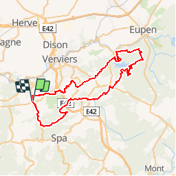
Tocht Mountainbike van 58 km beschikbaar op Wallonië, Luik, Theux. Deze tocht wordt voorgesteld door renodrex4910.
Beschrijving
Theux (Oneux) - Fays (Laboru) - Jehanster (Croix Petit Jean) - Gileppe (Bois de Goe et Hertogenwald) - Charneux (Bois du Moulin) - Polleur (Bois de Staneu)
Plaatsbepaling
Land:
Belgium
Regio :
Wallonië
Departement/Provincie :
Luik
Gemeente :
Theux
Locatie:
Theux
Vertrek:(Dec)
Vertrek:(UTM)
699246 ; 5602351 (31U) N.
Opmerkingen
Wandeltochten in de omgeving
![Tocht Stappen Theux - Theux - Natura 2000, des sites qui valent le détour - LG22 - Photo](https://media.geolcdn.com/t/375/260/ext.jpg?maxdim=2&url=https%3A%2F%2Fservices.sitytrail.com%2FGeolivesWS%2FDownloadMedia.ashx%3FTrailID%3D612638%26Media%3D53072597-f13a-4b1e-b213-a2c1df094f1f.JPG)
![Stappen Stappen](https://static1.geolcdn.com/sitytour/trail-icons/101.png)
Theux - Natura 2000, des sites qui valent le détour - LG22
Stappen
Medium
(6)
Theux,
Wallonië,
Luik,
Belgium
![](/images/other/stat-length.png)
12,7 km | 16,8 km-effort
3h 31min
![](https://static1.geolcdn.com/siteimages/upload/files/16400158638029165_repeat_loop_refresh_sync_direction_icon.png)
Ja
![Tocht Stappen Theux - RF-Lg-08_Franchimont_Grande-boucle - Photo](https://media.geolcdn.com/t/375/260/ext.jpg?maxdim=2&url=https%3A%2F%2Fstatic1.geolcdn.com%2Fsiteimages%2Fupload%2Ffiles%2F1553511878bg_sport_marche.png)
![Stappen Stappen](https://static1.geolcdn.com/sitytour/trail-icons/101.png)
RF-Lg-08_Franchimont_Grande-boucle
Stappen
Heel gemakkelijk
(6)
Theux,
Wallonië,
Luik,
Belgium
![](/images/other/stat-length.png)
10,8 km | 14,6 km-effort
3h 9min
![](https://static1.geolcdn.com/siteimages/upload/files/16400158638029165_repeat_loop_refresh_sync_direction_icon.png)
Ja
![Tocht Stappen Sprimont - Banneux - Rouge Thier - Adzeux - Photo](https://media.geolcdn.com/t/375/260/0f185ab2-d29a-4b49-b676-7a8415068951.jpg&format=jpg&maxdim=2)
![Stappen Stappen](https://static1.geolcdn.com/sitytour/trail-icons/101.png)
Banneux - Rouge Thier - Adzeux
Stappen
Gemakkelijk
(4)
Sprimont,
Wallonië,
Luik,
Belgium
![](/images/other/stat-length.png)
9,1 km | 11,3 km-effort
2h 34min
![](https://static1.geolcdn.com/siteimages/upload/files/16400158638029165_repeat_loop_refresh_sync_direction_icon.png)
Ja
![Tocht Te voet Spa - SPA 04 - Promenade du Golf (groene rechthoek) - Photo](https://media.geolcdn.com/t/375/260/96275f89-abfe-453d-984c-884201b099f1.jpg&format=jpg&maxdim=2)
![Te voet Te voet](https://static1.geolcdn.com/sitytour/trail-icons/100.png)
SPA 04 - Promenade du Golf (groene rechthoek)
Te voet
Gemakkelijk
(1)
Spa,
Wallonië,
Luik,
Belgium
![](/images/other/stat-length.png)
9,2 km | 12,2 km-effort
2h 46min
![](https://static1.geolcdn.com/siteimages/upload/files/16400158638029165_repeat_loop_refresh_sync_direction_icon.png)
Ja
![Tocht Stappen Spa - SPA 01 - Berkeley (Gele rechthoek) - Photo](https://media.geolcdn.com/t/375/260/b3d8e7d1-ae54-4d2c-ad3c-aa47c315b1ca.jpg&format=jpg&maxdim=2)
![Stappen Stappen](https://static1.geolcdn.com/sitytour/trail-icons/101.png)
SPA 01 - Berkeley (Gele rechthoek)
Stappen
Moeilijk
(2)
Spa,
Wallonië,
Luik,
Belgium
![](/images/other/stat-length.png)
9,4 km | 12,2 km-effort
2h 45min
![](https://static1.geolcdn.com/siteimages/upload/files/16400158638029165_repeat_loop_refresh_sync_direction_icon.png)
Ja
![Tocht Stappen Theux - Theux Natura 2000 château Franchimont - Photo](https://media.geolcdn.com/t/375/260/c750767f-f208-4264-8684-0a202377691f.jpg&format=jpg&maxdim=2)
![Stappen Stappen](https://static1.geolcdn.com/sitytour/trail-icons/101.png)
Theux Natura 2000 château Franchimont
Stappen
Medium
(2)
Theux,
Wallonië,
Luik,
Belgium
![](/images/other/stat-length.png)
13,1 km | 17,3 km-effort
3h 0min
![](https://static1.geolcdn.com/siteimages/upload/files/16400158638029165_repeat_loop_refresh_sync_direction_icon.png)
Ja
![Te voet Te voet](https://static1.geolcdn.com/sitytour/trail-icons/100.png)
Chemin des Sources - Kennismaking met wandelen in Polleur
Te voet
Gemakkelijk
(1)
Theux,
Wallonië,
Luik,
Belgium
![](/images/other/stat-length.png)
7,5 km | 9,9 km-effort
2h 14min
![](https://static1.geolcdn.com/siteimages/upload/files/16400158638029165_repeat_loop_refresh_sync_direction_icon.png)
Ja
![Tocht Te voet Spa - spa! Balmoral - een villawijk die traditie en innovatie combineert - Photo](https://media.geolcdn.com/t/375/260/11186514-2081-4754-a100-e300970b1adc.jpg&format=jpg&maxdim=2)
![Te voet Te voet](https://static1.geolcdn.com/sitytour/trail-icons/100.png)
spa! Balmoral - een villawijk die traditie en innovatie combineert
Te voet
Gemakkelijk
(1)
Spa,
Wallonië,
Luik,
Belgium
![](/images/other/stat-length.png)
3,3 km | 4,1 km-effort
56min
![](https://static1.geolcdn.com/siteimages/upload/files/16400158638029165_repeat_loop_refresh_sync_direction_icon.png)
Ja
![Tocht Trail Theux - Extratrail - Theux (blauw) 18 km - Photo](https://media.geolcdn.com/t/375/260/0911e17e-920d-442e-8495-16fc909f2c4f.jpg&format=jpg&maxdim=2)
![Trail Trail](https://static1.geolcdn.com/sitytour/trail-icons/104.png)
Extratrail - Theux (blauw) 18 km
Trail
Medium
(3)
Theux,
Wallonië,
Luik,
Belgium
![](/images/other/stat-length.png)
18,3 km | 25 km-effort
Onbekend
![](https://static1.geolcdn.com/siteimages/upload/files/16400158638029165_repeat_loop_refresh_sync_direction_icon.png)
Ja