![](/images/other/stat-length.png)
![Tocht Fiets Île-d'Aix - Tour de l'île d'Aix à vélo et à pied - Photo](https://media.geolcdn.com/t/1900/400/ext.pjpeg?maxdim=2&url=https%3A%2F%2Fstatic1.geolcdn.com%2Fsiteimages%2Fupload%2Ffiles%2F1524743154velo.jpg)
Tour de l'île d'Aix à vélo et à pied
Orage
Gebruiker
![Lengte](/images/other/stat-length.png)
Lengte
9,2 km
![Max. hoogte](https://static1.geolcdn.com/siteimages/upload/files/1508320355ic_sort_altitude_max_24dp.png)
Max. hoogte
17 m
![Positief hoogteverschil](https://static1.geolcdn.com/siteimages/upload/files/1508320355ic_sort_den_pos_24dp.png)
Positief hoogteverschil
47 m
![Km-Effort](/images/other/stat-length.png)
Km-Effort
9,8 km
![Min. hoogte](https://static1.geolcdn.com/siteimages/upload/files/1508320355ic_sort_altitude_min_24dp.png)
Min. hoogte
1 m
![Negatief hoogteverschil](https://static1.geolcdn.com/siteimages/upload/files/1508320355ic_sort_den_neg_24dp.png)
Negatief hoogteverschil
48 m
![Boucle](https://static1.geolcdn.com/siteimages/upload/files/16400158638029165_repeat_loop_refresh_sync_direction_icon.png)
Boucle
Ja
Datum van aanmaak :
2014-12-10 00:00:00.0
Laatste wijziging :
2014-12-10 00:00:00.0
![Fiets](https://static1.geolcdn.com/sitytour/trail-icons/200.png)
1h54
Moeilijkheid : Gemakkelijk
![Scan deze QR-code om de tocht te openen in de SityTrail-applicatie](https://capi.geolives.com/qq0zvz2zws4bq2lad0pu/sitytour/trails/147379/qr.png?size=200)
Gratisgps-wandelapplicatie
Over ons
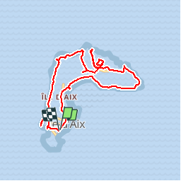
Tocht Fiets van 9,2 km beschikbaar op Nieuw-Aquitanië, Charente-Maritime, Île-d'Aix. Deze tocht wordt voorgesteld door Orage.
Beschrijving
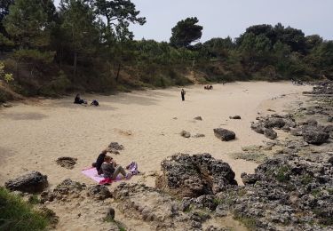
2 heures de balade plus baignade plage de l'anse de la Croix... et ne pas rater la dégustation d'huîtres chez Franck Speisser ostréiculteur.
Plaatsbepaling
Land:
France
Regio :
Nieuw-Aquitanië
Departement/Provincie :
Charente-Maritime
Gemeente :
Île-d'Aix
Locatie:
Unknown
Vertrek:(Dec)
Vertrek:(UTM)
641335 ; 5096929 (30T) N.
Opmerkingen
Wandeltochten in de omgeving
![Tocht Hybride fiets Île-d'Aix - Aix, croisière + rando vélo - Photo](https://media.geolcdn.com/t/375/260/f042a368-8e25-4b1c-b6d5-c6b43bc07f3d.jpg&format=jpg&maxdim=2)
![Hybride fiets Hybride fiets](https://static1.geolcdn.com/sitytour/trail-icons/203.png)
Aix, croisière + rando vélo
Hybride fiets
Île-d'Aix,
Nieuw-Aquitanië,
Charente-Maritime,
France
![](/images/other/stat-length.png)
5 km | 5,3 km-effort
1h 15min
![](https://static1.geolcdn.com/siteimages/upload/files/16400158638029165_repeat_loop_refresh_sync_direction_icon.png)
Neen
![Tocht Stappen Île-d'Aix - Tour de l'île d'Aix - Photo](https://media.geolcdn.com/t/375/260/ext.jpg?maxdim=2&url=https%3A%2F%2Fservices.sitytrail.com%2FGeolivesWS%2FDownloadMedia.ashx%3FTrailID%3D322742%26Media%3Dfix__20140710100457.jpg)
![Stappen Stappen](https://static1.geolcdn.com/sitytour/trail-icons/101.png)
Tour de l'île d'Aix
Stappen
Heel gemakkelijk
Île-d'Aix,
Nieuw-Aquitanië,
Charente-Maritime,
France
![](/images/other/stat-length.png)
7,7 km | 8,2 km-effort
1h 14min
![](https://static1.geolcdn.com/siteimages/upload/files/16400158638029165_repeat_loop_refresh_sync_direction_icon.png)
Ja
![Tocht Stappen Fouras - Fouras - Photo](https://media.geolcdn.com/t/375/260/1dc1062e-9ad7-497a-a167-18d03ac353e5.jpg&format=jpg&maxdim=2)
![Stappen Stappen](https://static1.geolcdn.com/sitytour/trail-icons/101.png)
Fouras
Stappen
Fouras,
Nieuw-Aquitanië,
Charente-Maritime,
France
![](/images/other/stat-length.png)
5,4 km | 5,8 km-effort
1h 37min
![](https://static1.geolcdn.com/siteimages/upload/files/16400158638029165_repeat_loop_refresh_sync_direction_icon.png)
Neen
![Tocht Stappen Île-d'Aix - tour de l'île complet - Photo](https://media.geolcdn.com/t/375/260/0e0ea078-1bf7-44ce-ae13-480f3e5ad038.jpg&format=jpg&maxdim=2)
![Stappen Stappen](https://static1.geolcdn.com/sitytour/trail-icons/101.png)
tour de l'île complet
Stappen
Medium
Île-d'Aix,
Nieuw-Aquitanië,
Charente-Maritime,
France
![](/images/other/stat-length.png)
9,2 km | 9,9 km-effort
4h 13min
![](https://static1.geolcdn.com/siteimages/upload/files/16400158638029165_repeat_loop_refresh_sync_direction_icon.png)
Neen
![Tocht Hybride fiets Île-d'Aix - Île d'Aix - Photo](https://media.geolcdn.com/t/375/260/abe6dde9-bc05-45d2-a924-3b81fee8ddfe.jpg&format=jpg&maxdim=2)
![Hybride fiets Hybride fiets](https://static1.geolcdn.com/sitytour/trail-icons/203.png)
Île d'Aix
Hybride fiets
Heel gemakkelijk
Île-d'Aix,
Nieuw-Aquitanië,
Charente-Maritime,
France
![](/images/other/stat-length.png)
8,7 km | 9,4 km-effort
1h 24min
![](https://static1.geolcdn.com/siteimages/upload/files/16400158638029165_repeat_loop_refresh_sync_direction_icon.png)
Ja
![Tocht Stappen Île-d'Aix - Île d’Aix - Photo](https://media.geolcdn.com/t/375/260/ext.jpg?maxdim=2&url=https%3A%2F%2Fstatic1.geolcdn.com%2Fsiteimages%2Fupload%2Ffiles%2F1553511878bg_sport_marche.png)
![Stappen Stappen](https://static1.geolcdn.com/sitytour/trail-icons/101.png)
Île d’Aix
Stappen
Medium
Île-d'Aix,
Nieuw-Aquitanië,
Charente-Maritime,
France
![](/images/other/stat-length.png)
9 km | 9,7 km-effort
2h 54min
![](https://static1.geolcdn.com/siteimages/upload/files/16400158638029165_repeat_loop_refresh_sync_direction_icon.png)
Neen
![Tocht Stappen Île-d'Aix - tour de l'île d'Aix - Photo](https://media.geolcdn.com/t/375/260/ext.jpg?maxdim=2&url=https%3A%2F%2Fstatic1.geolcdn.com%2Fsiteimages%2Fupload%2Ffiles%2F1553511878bg_sport_marche.png)
![Stappen Stappen](https://static1.geolcdn.com/sitytour/trail-icons/101.png)
tour de l'île d'Aix
Stappen
Gemakkelijk
Île-d'Aix,
Nieuw-Aquitanië,
Charente-Maritime,
France
![](/images/other/stat-length.png)
9,1 km | 9,9 km-effort
5h 33min
![](https://static1.geolcdn.com/siteimages/upload/files/16400158638029165_repeat_loop_refresh_sync_direction_icon.png)
Ja
![Tocht Stappen Île-d'Aix - Tour de l'île d'Aix - Photo](https://media.geolcdn.com/t/375/260/ext.jpg?maxdim=2&url=https%3A%2F%2Fstatic1.geolcdn.com%2Fsiteimages%2Fupload%2Ffiles%2F1553511878bg_sport_marche.png)
![Stappen Stappen](https://static1.geolcdn.com/sitytour/trail-icons/101.png)
Tour de l'île d'Aix
Stappen
Gemakkelijk
Île-d'Aix,
Nieuw-Aquitanië,
Charente-Maritime,
France
![](/images/other/stat-length.png)
8 km | 8,6 km-effort
3h 24min
![](https://static1.geolcdn.com/siteimages/upload/files/16400158638029165_repeat_loop_refresh_sync_direction_icon.png)
Ja
![Tocht Lopen Île-d'Aix - petit tour sur l île d Aix - Photo](https://media.geolcdn.com/t/375/260/ext.jpg?maxdim=2&url=https%3A%2F%2Fstatic1.geolcdn.com%2Fsiteimages%2Fupload%2Ffiles%2F1524743154running.jpg)
![Lopen Lopen](https://static1.geolcdn.com/sitytour/trail-icons/103.png)
petit tour sur l île d Aix
Lopen
Heel gemakkelijk
Île-d'Aix,
Nieuw-Aquitanië,
Charente-Maritime,
France
![](/images/other/stat-length.png)
10 km | 10,7 km-effort
1h 3min
![](https://static1.geolcdn.com/siteimages/upload/files/16400158638029165_repeat_loop_refresh_sync_direction_icon.png)
Ja