![](/images/other/stat-length.png)
![Tocht Lopen Sainte-Austreberthe - Hivernale du Raid Normand - Photo](https://media.geolcdn.com/t/1900/400/ext.pjpeg?maxdim=2&url=https%3A%2F%2Fstatic1.geolcdn.com%2Fsiteimages%2Fupload%2Ffiles%2F1524743154running.jpg)
Hivernale du Raid Normand
hgoye
Gebruiker
![Lengte](/images/other/stat-length.png)
Lengte
48 km
![Max. hoogte](https://static1.geolcdn.com/siteimages/upload/files/1508320355ic_sort_altitude_max_24dp.png)
Max. hoogte
154 m
![Positief hoogteverschil](https://static1.geolcdn.com/siteimages/upload/files/1508320355ic_sort_den_pos_24dp.png)
Positief hoogteverschil
933 m
![Km-Effort](/images/other/stat-length.png)
Km-Effort
61 km
![Min. hoogte](https://static1.geolcdn.com/siteimages/upload/files/1508320355ic_sort_altitude_min_24dp.png)
Min. hoogte
2 m
![Negatief hoogteverschil](https://static1.geolcdn.com/siteimages/upload/files/1508320355ic_sort_den_neg_24dp.png)
Negatief hoogteverschil
1049 m
![Boucle](https://static1.geolcdn.com/siteimages/upload/files/16400158638029165_repeat_loop_refresh_sync_direction_icon.png)
Boucle
Neen
Datum van aanmaak :
2014-12-10 00:00:00.0
Laatste wijziging :
2014-12-10 00:00:00.0
![Lopen](https://static1.geolcdn.com/sitytour/trail-icons/103.png)
10h29
Moeilijkheid : Zeer moeilijk
![Scan deze QR-code om de tocht te openen in de SityTrail-applicatie](https://capi.geolives.com/qq0zvz2zws4bq2lad0pu/sitytour/trails/146915/qr.png?size=200)
Gratisgps-wandelapplicatie
Over ons
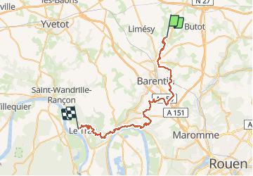
Tocht Lopen van 48 km beschikbaar op Normandië, Seine-Maritime, Sainte-Austreberthe. Deze tocht wordt voorgesteld door hgoye.
Beschrijving
Parcours de l'hivernale du RAID Normand 2012. Parcours 42 kilomètres (à la base) qui en fait pas loin de 49 en définitive.
POI's
Plaatsbepaling
Land:
France
Regio :
Normandië
Departement/Provincie :
Seine-Maritime
Gemeente :
Sainte-Austreberthe
Locatie:
Unknown
Vertrek:(Dec)
Vertrek:(UTM)
353612 ; 5496163 (31U) N.
Opmerkingen
Wandeltochten in de omgeving
![Tocht Stappen Pavilly - 076-90-Pavilly / St Autreberthe 13.5km - Photo](https://media.geolcdn.com/t/375/260/a210e569-e658-42b2-bef9-eb8848a71140.jpg&format=jpg&maxdim=2)
![Stappen Stappen](https://static1.geolcdn.com/sitytour/trail-icons/101.png)
076-90-Pavilly / St Autreberthe 13.5km
Stappen
Medium
(1)
Pavilly,
Normandië,
Seine-Maritime,
France
![](/images/other/stat-length.png)
12 km | 15 km-effort
3h 23min
![](https://static1.geolcdn.com/siteimages/upload/files/16400158638029165_repeat_loop_refresh_sync_direction_icon.png)
Ja
![Stappen Stappen](https://static1.geolcdn.com/sitytour/trail-icons/101.png)
20220203-Pavilly
Stappen
Medium
Pavilly,
Normandië,
Seine-Maritime,
France
![](/images/other/stat-length.png)
12,1 km | 15 km-effort
3h 36min
![](https://static1.geolcdn.com/siteimages/upload/files/16400158638029165_repeat_loop_refresh_sync_direction_icon.png)
Ja
![Tocht Stappen Butot - Butot -76- Chemin de randonnée le BOis de Grosfy - Photo](https://media.geolcdn.com/t/375/260/f0adff7e-0510-443c-91e0-549769fd08c0.jpg&format=jpg&maxdim=2)
![Stappen Stappen](https://static1.geolcdn.com/sitytour/trail-icons/101.png)
Butot -76- Chemin de randonnée le BOis de Grosfy
Stappen
Moeilijk
Butot,
Normandië,
Seine-Maritime,
France
![](/images/other/stat-length.png)
14,5 km | 16,7 km-effort
4h 3min
![](https://static1.geolcdn.com/siteimages/upload/files/16400158638029165_repeat_loop_refresh_sync_direction_icon.png)
Ja
![Tocht Stappen Pavilly - Pavilly St. Austreberthe (51) - Photo](https://media.geolcdn.com/t/375/260/ext.jpg?maxdim=2&url=https%3A%2F%2Fstatic1.geolcdn.com%2Fsiteimages%2Fupload%2Ffiles%2F1553511878bg_sport_marche.png)
![Stappen Stappen](https://static1.geolcdn.com/sitytour/trail-icons/101.png)
Pavilly St. Austreberthe (51)
Stappen
Gemakkelijk
(2)
Pavilly,
Normandië,
Seine-Maritime,
France
![](/images/other/stat-length.png)
10,3 km | 13 km-effort
2h 49min
![](https://static1.geolcdn.com/siteimages/upload/files/16400158638029165_repeat_loop_refresh_sync_direction_icon.png)
Ja
![Tocht Stappen Goupillières - Goupillieres 6 - Photo](https://media.geolcdn.com/t/375/260/d20b3b5a-9e1f-403e-b83f-9397a3ba6e1b.jpg&format=jpg&maxdim=2)
![Stappen Stappen](https://static1.geolcdn.com/sitytour/trail-icons/101.png)
Goupillieres 6
Stappen
Gemakkelijk
Goupillières,
Normandië,
Seine-Maritime,
France
![](/images/other/stat-length.png)
6,8 km | 7,6 km-effort
1h 40min
![](https://static1.geolcdn.com/siteimages/upload/files/16400158638029165_repeat_loop_refresh_sync_direction_icon.png)
Ja
![Tocht Te voet Hugleville-en-Caux - Le Bois de Grofys - Photo](https://media.geolcdn.com/t/375/260/ext.jpg?maxdim=2&url=https%3A%2F%2Fstatic1.geolcdn.com%2Fsiteimages%2Fupload%2Ffiles%2F1545311037marcheuse_200dpi.jpg)
![Te voet Te voet](https://static1.geolcdn.com/sitytour/trail-icons/100.png)
Le Bois de Grofys
Te voet
Gemakkelijk
Hugleville-en-Caux,
Normandië,
Seine-Maritime,
France
![](/images/other/stat-length.png)
11,6 km | 13,3 km-effort
3h 1min
![](https://static1.geolcdn.com/siteimages/upload/files/16400158638029165_repeat_loop_refresh_sync_direction_icon.png)
Ja
![Tocht Te voet Pavilly - 2020-01-22_15h00m10_20200125-pavilly - Photo](https://media.geolcdn.com/t/375/260/fca199ec-9bf4-4b5c-87b4-2fd7de5421ae.jpg&format=jpg&maxdim=2)
![Te voet Te voet](https://static1.geolcdn.com/sitytour/trail-icons/100.png)
2020-01-22_15h00m10_20200125-pavilly
Te voet
Heel gemakkelijk
Pavilly,
Normandië,
Seine-Maritime,
France
![](/images/other/stat-length.png)
13 km | 16 km-effort
Onbekend
![](https://static1.geolcdn.com/siteimages/upload/files/16400158638029165_repeat_loop_refresh_sync_direction_icon.png)
Ja
![Tocht Stappen Sainte-Austreberthe - Ste Austreberthe Pavilly A-R - Photo](https://media.geolcdn.com/t/375/260/ext.jpg?maxdim=2&url=https%3A%2F%2Fservices.sitytrail.com%2FGeolivesWS%2FDownloadMedia.ashx%3FTrailID%3D908132%26Media%3Dfix__20180218155800.jpg)
![Stappen Stappen](https://static1.geolcdn.com/sitytour/trail-icons/101.png)
Ste Austreberthe Pavilly A-R
Stappen
Moeilijk
Sainte-Austreberthe,
Normandië,
Seine-Maritime,
France
![](/images/other/stat-length.png)
12,5 km | 15,6 km-effort
3h 7min
![](https://static1.geolcdn.com/siteimages/upload/files/16400158638029165_repeat_loop_refresh_sync_direction_icon.png)
Ja
![Tocht Stappen Pavilly - 076-89-Pavilly Ste Austreberthe route du Lin 11km-877-716- - Photo](https://media.geolcdn.com/t/375/260/67b859b5-ac7f-468e-ba6f-19151b8fc1e7.jpg&format=jpg&maxdim=2)
![Stappen Stappen](https://static1.geolcdn.com/sitytour/trail-icons/101.png)
076-89-Pavilly Ste Austreberthe route du Lin 11km-877-716-
Stappen
Gemakkelijk
Pavilly,
Normandië,
Seine-Maritime,
France
![](/images/other/stat-length.png)
11 km | 13,7 km-effort
2h 56min
![](https://static1.geolcdn.com/siteimages/upload/files/16400158638029165_repeat_loop_refresh_sync_direction_icon.png)
Ja