![](/images/other/stat-length.png)
![Tocht Stappen Revin - Revin: Mont Malgré Tout - Photo](https://media.geolcdn.com/t/1900/400/ext.pjpeg?maxdim=2&url=https%3A%2F%2Fservices.sitytrail.com%2FGeolivesWS%2FDownloadMedia.ashx%3FTrailID%3D144572%26Media%3D20120720155545.jpeg)
Revin: Mont Malgré Tout
jeepee93
Gebruiker
![Lengte](/images/other/stat-length.png)
Lengte
15,1 km
![Max. hoogte](https://static1.geolcdn.com/siteimages/upload/files/1508320355ic_sort_altitude_max_24dp.png)
Max. hoogte
446 m
![Positief hoogteverschil](https://static1.geolcdn.com/siteimages/upload/files/1508320355ic_sort_den_pos_24dp.png)
Positief hoogteverschil
410 m
![Km-Effort](/images/other/stat-length.png)
Km-Effort
21 km
![Min. hoogte](https://static1.geolcdn.com/siteimages/upload/files/1508320355ic_sort_altitude_min_24dp.png)
Min. hoogte
122 m
![Negatief hoogteverschil](https://static1.geolcdn.com/siteimages/upload/files/1508320355ic_sort_den_neg_24dp.png)
Negatief hoogteverschil
411 m
![Boucle](https://static1.geolcdn.com/siteimages/upload/files/16400158638029165_repeat_loop_refresh_sync_direction_icon.png)
Boucle
Ja
Datum van aanmaak :
2014-12-10 00:00:00.0
Laatste wijziging :
2014-12-10 00:00:00.0
![Stappen](https://static1.geolcdn.com/sitytour/trail-icons/101.png)
4h09
Moeilijkheid : Medium
![Scan deze QR-code om de tocht te openen in de SityTrail-applicatie](https://capi.geolives.com/qq0zvz2zws4bq2lad0pu/sitytour/trails/144572/qr.png?size=200)
Gratisgps-wandelapplicatie
Over ons
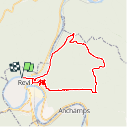
Tocht Stappen van 15,1 km beschikbaar op Grand Est, Ardennes, Revin. Deze tocht wordt voorgesteld door jeepee93.
Beschrijving
Départ de l'office de tourisme, suivre le marquage "gros points" rouge.
Boucle dans le sens des aiguilles d'une montre.
Plaatsbepaling
Land:
France
Regio :
Grand Est
Departement/Provincie :
Ardennes
Gemeente :
Revin
Locatie:
Unknown
Vertrek:(Dec)
Vertrek:(UTM)
617306 ; 5533698 (31U) N.
Opmerkingen
Wandeltochten in de omgeving
![Tocht Stappen Rocroi - revin saint nicolas bassin witaker - Photo](https://media.geolcdn.com/t/375/260/34767dce-ee8b-4315-b19c-69e706631eb5.jpg&format=jpg&maxdim=2)
![Stappen Stappen](https://static1.geolcdn.com/sitytour/trail-icons/101.png)
revin saint nicolas bassin witaker
Stappen
Medium
Rocroi,
Grand Est,
Ardennes,
France
![](/images/other/stat-length.png)
14,6 km | 19,5 km-effort
4h 26min
![](https://static1.geolcdn.com/siteimages/upload/files/16400158638029165_repeat_loop_refresh_sync_direction_icon.png)
Ja
![Tocht Stappen Revin - de Layfour à Anchamps - Photo](https://media.geolcdn.com/t/375/260/6644a90b-6b10-4064-893f-3442ceb4d9e6.jpg&format=jpg&maxdim=2)
![Stappen Stappen](https://static1.geolcdn.com/sitytour/trail-icons/101.png)
de Layfour à Anchamps
Stappen
Zeer moeilijk
Revin,
Grand Est,
Ardennes,
France
![](/images/other/stat-length.png)
15,2 km | 20 km-effort
4h 1min
![](https://static1.geolcdn.com/siteimages/upload/files/16400158638029165_repeat_loop_refresh_sync_direction_icon.png)
Neen
![Tocht Stappen Revin - 2022-04-25_16h18m48_SityTrail - 2733173 - revinxmalgre-tout4x2021x04x03 (1) (1) - Photo](https://media.geolcdn.com/t/375/260/ext.jpg?maxdim=2&url=https%3A%2F%2Fstatic1.geolcdn.com%2Fsiteimages%2Fupload%2Ffiles%2F1553511878bg_sport_marche.png)
![Stappen Stappen](https://static1.geolcdn.com/sitytour/trail-icons/101.png)
2022-04-25_16h18m48_SityTrail - 2733173 - revinxmalgre-tout4x2021x04x03 (1) (1)
Stappen
Moeilijk
(1)
Revin,
Grand Est,
Ardennes,
France
![](/images/other/stat-length.png)
9,5 km | 12,1 km-effort
2h 44min
![](https://static1.geolcdn.com/siteimages/upload/files/16400158638029165_repeat_loop_refresh_sync_direction_icon.png)
Ja
![Tocht Stappen Laifour - Laifour 21,7 km - Photo](https://media.geolcdn.com/t/375/260/ext.jpg?maxdim=2&url=https%3A%2F%2Fservices.sitytrail.com%2FGeolivesWS%2FDownloadMedia.ashx%3FTrailID%3D1032859%26Media%3D20180902161207.jpg)
![Stappen Stappen](https://static1.geolcdn.com/sitytour/trail-icons/101.png)
Laifour 21,7 km
Stappen
Medium
Laifour,
Grand Est,
Ardennes,
France
![](/images/other/stat-length.png)
22 km | 32 km-effort
7h 15min
![](https://static1.geolcdn.com/siteimages/upload/files/16400158638029165_repeat_loop_refresh_sync_direction_icon.png)
Ja
![Tocht Stappen Revin - Balade à Revin - Les Bois Bryas - Photo](https://media.geolcdn.com/t/375/260/ext.jpg?maxdim=2&url=https%3A%2F%2Fservices.sitytrail.com%2FGeolivesWS%2FDownloadMedia.ashx%3FTrailID%3D317410%26Media%3D16633_6.jpg)
![Stappen Stappen](https://static1.geolcdn.com/sitytour/trail-icons/101.png)
Balade à Revin - Les Bois Bryas
Stappen
Medium
Revin,
Grand Est,
Ardennes,
France
![](/images/other/stat-length.png)
9,2 km | 13,3 km-effort
2h 15min
![](https://static1.geolcdn.com/siteimages/upload/files/16400158638029165_repeat_loop_refresh_sync_direction_icon.png)
Ja
![Tocht Mountainbike Revin - Révin - Les Bois Bryas - Ri d'Alyse et d'Oignies - Photo](https://media.geolcdn.com/t/375/260/ext.jpg?maxdim=2&url=https%3A%2F%2Fservices.sitytrail.com%2FGeolivesWS%2FDownloadMedia.ashx%3FTrailID%3D317135%26Media%3D16286_6.jpg)
![Mountainbike Mountainbike](https://static1.geolcdn.com/sitytour/trail-icons/202.png)
Révin - Les Bois Bryas - Ri d'Alyse et d'Oignies
Mountainbike
Moeilijk
Revin,
Grand Est,
Ardennes,
France
![](/images/other/stat-length.png)
25 km | 35 km-effort
3h 10min
![](https://static1.geolcdn.com/siteimages/upload/files/16400158638029165_repeat_loop_refresh_sync_direction_icon.png)
Ja
![Tocht Mountainbike Revin - De Revin à Laifour par les Dames de Meuse - Photo](https://media.geolcdn.com/t/375/260/ext.jpg?maxdim=2&url=https%3A%2F%2Fservices.sitytrail.com%2FGeolivesWS%2FDownloadMedia.ashx%3FTrailID%3D316955%26Media%3D16071_1.jpg)
![Mountainbike Mountainbike](https://static1.geolcdn.com/sitytour/trail-icons/202.png)
De Revin à Laifour par les Dames de Meuse
Mountainbike
Moeilijk
Revin,
Grand Est,
Ardennes,
France
![](/images/other/stat-length.png)
30 km | 41 km-effort
3h 0min
![](https://static1.geolcdn.com/siteimages/upload/files/16400158638029165_repeat_loop_refresh_sync_direction_icon.png)
Ja
![Tocht Mountainbike Rocroi - Révin - Dames de Meuse - Anchamps - Photo](https://media.geolcdn.com/t/375/260/ext.jpg?maxdim=2&url=https%3A%2F%2Fservices.sitytrail.com%2FGeolivesWS%2FDownloadMedia.ashx%3FTrailID%3D316865%26Media%3D15946_1.jpg)
![Mountainbike Mountainbike](https://static1.geolcdn.com/sitytour/trail-icons/202.png)
Révin - Dames de Meuse - Anchamps
Mountainbike
Moeilijk
Rocroi,
Grand Est,
Ardennes,
France
![](/images/other/stat-length.png)
30 km | 39 km-effort
2h 30min
![](https://static1.geolcdn.com/siteimages/upload/files/16400158638029165_repeat_loop_refresh_sync_direction_icon.png)
Ja
![Tocht Mountainbike Revin - Witaker - Bois de Hiraumont - Revin - Photo](https://media.geolcdn.com/t/375/260/ext.jpg?maxdim=2&url=https%3A%2F%2Fservices.sitytrail.com%2FGeolivesWS%2FDownloadMedia.ashx%3FTrailID%3D214919%26Media%3D15487_6.jpg)
![Mountainbike Mountainbike](https://static1.geolcdn.com/sitytour/trail-icons/202.png)
Witaker - Bois de Hiraumont - Revin
Mountainbike
Moeilijk
Revin,
Grand Est,
Ardennes,
France
![](/images/other/stat-length.png)
27 km | 35 km-effort
2h 45min
![](https://static1.geolcdn.com/siteimages/upload/files/16400158638029165_repeat_loop_refresh_sync_direction_icon.png)
Ja