Tocht Andere activiteiten Saint-Martin-la-Pallu - vendeuvre001 - Photo
 archos60
archos60

Gebruiker

© OpenStreetMap contributors
Lengte
Lengte
5,8 km
Max. hoogte
Max. hoogte
104 m
Positief hoogteverschil
42 m
Km-Effort
Km-Effort  
6,3 km
Min. hoogte
Min. hoogte
76 m
Negatief hoogteverschil
43 m
Boucle
Boucle
Ja
Datum van aanmaak :
2014-12-10 00:00:00.0
Laatste wijziging :
2014-12-10 00:00:00.0

(0 Bericht)

Andere activiteiten
Andere activiteiten
--
Moeilijkheid : Medium

Scan deze QR-code om de tocht te openen in de SityTrail-applicatie

Gratisgps-wandelapplicatie

Logo SityTrail SityTrail

IGN / Geografische instituten

SityTrail uit de App Store downloaden SityTrail uit Google Play downloaden

Logo SityTrail SityTrail World

De wereld gaat voor u open

SityTrail uit de App Store downloaden SityTrail uit Google Play downloaden SityTrail op Huawei AppGallery downloaden

Over ons

Tocht Andere activiteiten van 5,8 km beschikbaar op Nieuw-Aquitanië, Vienne, Saint-Martin-la-Pallu. Deze tocht wordt voorgesteld door archos60.

Beschrijving

tour de vendeuvre par les tours mirandes et marais

Hoogteprofiel

Plaatsbepaling

Land:
France
Regio :
Nieuw-Aquitanië
Departement/Provincie :
Vienne
Gemeente :
Saint-Martin-la-Pallu
Locatie:
Vendeuvre-du-Poitou
Vertrek:(Dec)
Vertrek:(UTM)
293839 ; 5178519 (31T) N.

Wandeltochten in de omgeving

Tocht Stappen Saint-Martin-la-Pallu - cheneché - Photo
Stappen
Patlac3

Stappen

Gemakkelijk
Saint-Martin-la-Pallu, Nieuw-Aquitanië, Vienne, France
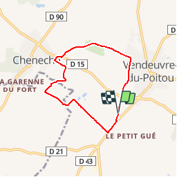
12,1 km | 13,1 km-effort
2h 19min
Ja
Tocht Stappen Saint-Martin-la-Pallu - vendeuvre  - Photo
Stappen
Patlac3

Stappen

Gemakkelijk
Saint-Martin-la-Pallu, Nieuw-Aquitanië, Vienne, France
10,7 km | 12,8 km-effort
2h 30min
Ja
Tocht Stappen Saint-Martin-la-Pallu - balade Nath - Photo
Stappen
Lao

Stappen

Heel gemakkelijk
Saint-Martin-la-Pallu, Nieuw-Aquitanië, Vienne, France
13,5 km | 14,8 km-effort
3h 13min
Ja


Sluiten
Mijn abonnementen