![](/images/other/stat-length.png)
![Tocht Stappen Bray-et-Lû - Bray et Lu - Photo](https://media.geolcdn.com/t/1900/400/ext.pjpeg?maxdim=2&url=https%3A%2F%2Fservices.sitytrail.com%2FGeolivesWS%2FDownloadMedia.ashx%3FTrailID%3D142286%26Media%3Ddfc1e947-00d4-4b9d-9ff5-da24a2a7af4f.jpeg)
Bray et Lu
francois911
Gebruiker
![Lengte](/images/other/stat-length.png)
Lengte
14,2 km
![Max. hoogte](https://static1.geolcdn.com/siteimages/upload/files/1508320355ic_sort_altitude_max_24dp.png)
Max. hoogte
149 m
![Positief hoogteverschil](https://static1.geolcdn.com/siteimages/upload/files/1508320355ic_sort_den_pos_24dp.png)
Positief hoogteverschil
278 m
![Km-Effort](/images/other/stat-length.png)
Km-Effort
17,9 km
![Min. hoogte](https://static1.geolcdn.com/siteimages/upload/files/1508320355ic_sort_altitude_min_24dp.png)
Min. hoogte
28 m
![Negatief hoogteverschil](https://static1.geolcdn.com/siteimages/upload/files/1508320355ic_sort_den_neg_24dp.png)
Negatief hoogteverschil
277 m
![Boucle](https://static1.geolcdn.com/siteimages/upload/files/16400158638029165_repeat_loop_refresh_sync_direction_icon.png)
Boucle
Ja
Datum van aanmaak :
2014-12-10 00:00:00.0
Laatste wijziging :
2014-12-10 00:00:00.0
![Stappen](https://static1.geolcdn.com/sitytour/trail-icons/101.png)
3h20
Moeilijkheid : Medium
![Scan deze QR-code om de tocht te openen in de SityTrail-applicatie](https://capi.geolives.com/qq0zvz2zws4bq2lad0pu/sitytour/trails/142286/qr.png?size=200)
Gratisgps-wandelapplicatie
Over ons
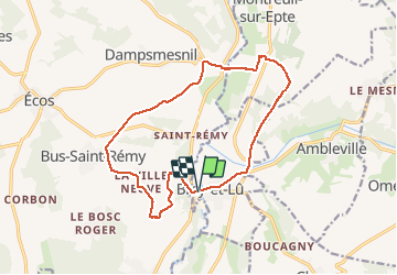
Tocht Stappen van 14,2 km beschikbaar op Île-de-France, Val-d'Oise, Bray-et-Lû. Deze tocht wordt voorgesteld door francois911.
Beschrijving
Situation:Bray et Lu est à 11km à l'ouest de Magny en Vexin par la D86.
A découvrir en chemin :
. Bray et Lu l'église Notre-Dame XII-XIX°
. Aveny : pont XV°, château XV°
. Baudemont : ruines du chäteau
POI's
Plaatsbepaling
Land:
France
Regio :
Île-de-France
Departement/Provincie :
Val-d'Oise
Gemeente :
Bray-et-Lû
Locatie:
Unknown
Vertrek:(Dec)
Vertrek:(UTM)
401926 ; 5443799 (31U) N.
Opmerkingen
Wandeltochten in de omgeving
![Tocht Stappen Chaussy - Chaussy - Villarceaux vers Chaussy - Photo](https://media.geolcdn.com/t/375/260/ext.jpg?maxdim=2&url=https%3A%2F%2Fstatic1.geolcdn.com%2Fsiteimages%2Fupload%2Ffiles%2F1553511878bg_sport_marche.png)
![Stappen Stappen](https://static1.geolcdn.com/sitytour/trail-icons/101.png)
Chaussy - Villarceaux vers Chaussy
Stappen
Gemakkelijk
(1)
Chaussy,
Île-de-France,
Val-d'Oise,
France
![](/images/other/stat-length.png)
10,4 km | 12,9 km-effort
2h 48min
![](https://static1.geolcdn.com/siteimages/upload/files/16400158638029165_repeat_loop_refresh_sync_direction_icon.png)
Ja
![Tocht Stappen Chaussy - Chaussy - Villarceaux - Genainville - Photo](https://media.geolcdn.com/t/375/260/ext.jpg?maxdim=2&url=https%3A%2F%2Fstatic1.geolcdn.com%2Fsiteimages%2Fupload%2Ffiles%2F1553511878bg_sport_marche.png)
![Stappen Stappen](https://static1.geolcdn.com/sitytour/trail-icons/101.png)
Chaussy - Villarceaux - Genainville
Stappen
Gemakkelijk
(1)
Chaussy,
Île-de-France,
Val-d'Oise,
France
![](/images/other/stat-length.png)
11,3 km | 13,7 km-effort
2h 57min
![](https://static1.geolcdn.com/siteimages/upload/files/16400158638029165_repeat_loop_refresh_sync_direction_icon.png)
Ja
![Tocht Stappen Vexin-sur-Epte - Rando Douce 1 - Ecos - Photo](https://media.geolcdn.com/t/375/260/ext.jpg?maxdim=2&url=https%3A%2F%2Fstatic1.geolcdn.com%2Fsiteimages%2Fupload%2Ffiles%2F1553511878bg_sport_marche.png)
![Stappen Stappen](https://static1.geolcdn.com/sitytour/trail-icons/101.png)
Rando Douce 1 - Ecos
Stappen
Gemakkelijk
(1)
Vexin-sur-Epte,
Normandië,
Eure,
France
![](/images/other/stat-length.png)
6,5 km | 7,6 km-effort
1h 28min
![](https://static1.geolcdn.com/siteimages/upload/files/16400158638029165_repeat_loop_refresh_sync_direction_icon.png)
Ja
![Tocht Stappen Vexin-sur-Epte - Ecos - les trois boucles court - Photo](https://media.geolcdn.com/t/375/260/ext.jpg?maxdim=2&url=https%3A%2F%2Fstatic1.geolcdn.com%2Fsiteimages%2Fupload%2Ffiles%2F1553511878bg_sport_marche.png)
![Stappen Stappen](https://static1.geolcdn.com/sitytour/trail-icons/101.png)
Ecos - les trois boucles court
Stappen
Gemakkelijk
(2)
Vexin-sur-Epte,
Normandië,
Eure,
France
![](/images/other/stat-length.png)
11,1 km | 13,1 km-effort
2h 51min
![](https://static1.geolcdn.com/siteimages/upload/files/16400158638029165_repeat_loop_refresh_sync_direction_icon.png)
Ja
![Tocht Stappen Omerville - omerville et alentours - Photo](https://media.geolcdn.com/t/375/260/ext.jpg?maxdim=2&url=https%3A%2F%2Fstatic1.geolcdn.com%2Fsiteimages%2Fupload%2Ffiles%2F1553511878bg_sport_marche.png)
![Stappen Stappen](https://static1.geolcdn.com/sitytour/trail-icons/101.png)
omerville et alentours
Stappen
Gemakkelijk
(3)
Omerville,
Île-de-France,
Val-d'Oise,
France
![](/images/other/stat-length.png)
12,7 km | 16 km-effort
3h 17min
![](https://static1.geolcdn.com/siteimages/upload/files/16400158638029165_repeat_loop_refresh_sync_direction_icon.png)
Ja
![Tocht Stappen Vexin-sur-Epte - Berthenonville Dampsmesni la côte aux chiens - Photo](https://media.geolcdn.com/t/375/260/ext.jpg?maxdim=2&url=https%3A%2F%2Fstatic1.geolcdn.com%2Fsiteimages%2Fupload%2Ffiles%2F1553511878bg_sport_marche.png)
![Stappen Stappen](https://static1.geolcdn.com/sitytour/trail-icons/101.png)
Berthenonville Dampsmesni la côte aux chiens
Stappen
Medium
(1)
Vexin-sur-Epte,
Normandië,
Eure,
France
![](/images/other/stat-length.png)
9,5 km | 12,7 km-effort
2h 16min
![](https://static1.geolcdn.com/siteimages/upload/files/16400158638029165_repeat_loop_refresh_sync_direction_icon.png)
Ja
![Tocht Stappen Montreuil-sur-Epte - Montreuil sur Epte La Chapelle en Vexin - Photo](https://media.geolcdn.com/t/375/260/ext.jpg?maxdim=2&url=https%3A%2F%2Fstatic1.geolcdn.com%2Fsiteimages%2Fupload%2Ffiles%2F1553511878bg_sport_marche.png)
![Stappen Stappen](https://static1.geolcdn.com/sitytour/trail-icons/101.png)
Montreuil sur Epte La Chapelle en Vexin
Stappen
Moeilijk
(1)
Montreuil-sur-Epte,
Île-de-France,
Val-d'Oise,
France
![](/images/other/stat-length.png)
11,1 km | 13,6 km-effort
3h 48min
![](https://static1.geolcdn.com/siteimages/upload/files/16400158638029165_repeat_loop_refresh_sync_direction_icon.png)
Ja
![Tocht Stappen Omerville - 180503 - Omerville - Photo](https://media.geolcdn.com/t/375/260/ext.jpg?maxdim=2&url=https%3A%2F%2Fstatic1.geolcdn.com%2Fsiteimages%2Fupload%2Ffiles%2F1553511878bg_sport_marche.png)
![Stappen Stappen](https://static1.geolcdn.com/sitytour/trail-icons/101.png)
180503 - Omerville
Stappen
Gemakkelijk
(1)
Omerville,
Île-de-France,
Val-d'Oise,
France
![](/images/other/stat-length.png)
13,3 km | 17,4 km-effort
3h 21min
![](https://static1.geolcdn.com/siteimages/upload/files/16400158638029165_repeat_loop_refresh_sync_direction_icon.png)
Ja
![Tocht Stappen Vexin-sur-Epte - Aveny - Photo](https://media.geolcdn.com/t/375/260/9eb6f109-b6e3-4fd0-a8ae-6ceb0efee5b8.jpg&format=jpg&maxdim=2)
![Stappen Stappen](https://static1.geolcdn.com/sitytour/trail-icons/101.png)
Aveny
Stappen
Gemakkelijk
Vexin-sur-Epte,
Normandië,
Eure,
France
![](/images/other/stat-length.png)
7,2 km | 9,2 km-effort
2h 18min
![](https://static1.geolcdn.com/siteimages/upload/files/16400158638029165_repeat_loop_refresh_sync_direction_icon.png)
Neen