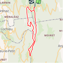
![](/images/other/stat-length.png)
![Tocht Stappen Corbonod - 01- Le Grand Colombier - Photo](https://media.geolcdn.com/t/1900/400/ext.pjpeg?maxdim=2&url=https%3A%2F%2Fstatic1.geolcdn.com%2Fsiteimages%2Fupload%2Ffiles%2F1553511878bg_sport_marche.png)
01- Le Grand Colombier
cavpsy74
Gebruiker
![Lengte](/images/other/stat-length.png)
![Max. hoogte](https://static1.geolcdn.com/siteimages/upload/files/1508320355ic_sort_altitude_max_24dp.png)
![Positief hoogteverschil](https://static1.geolcdn.com/siteimages/upload/files/1508320355ic_sort_den_pos_24dp.png)
![Km-Effort](/images/other/stat-length.png)
![Min. hoogte](https://static1.geolcdn.com/siteimages/upload/files/1508320355ic_sort_altitude_min_24dp.png)
![Negatief hoogteverschil](https://static1.geolcdn.com/siteimages/upload/files/1508320355ic_sort_den_neg_24dp.png)
![Boucle](https://static1.geolcdn.com/siteimages/upload/files/16400158638029165_repeat_loop_refresh_sync_direction_icon.png)
![Stappen](https://static1.geolcdn.com/sitytour/trail-icons/101.png)
4h42
Moeilijkheid : Medium
![Scan deze QR-code om de tocht te openen in de SityTrail-applicatie](https://capi.geolives.com/qq0zvz2zws4bq2lad0pu/sitytour/trails/140420/qr.png?size=200)
Gratisgps-wandelapplicatie
Over ons
Tocht Stappen van 14,1 km beschikbaar op Auvergne-Rhône-Alpes, Ain, Corbonod. Deze tocht wordt voorgesteld door cavpsy74.
Beschrijving
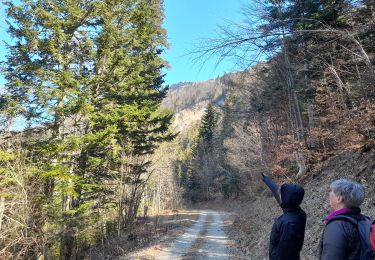
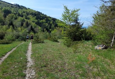
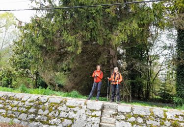
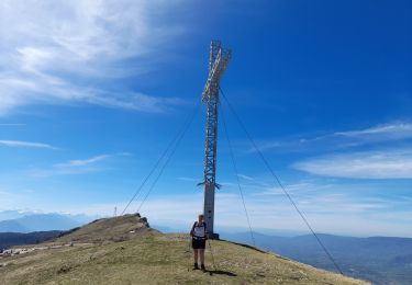
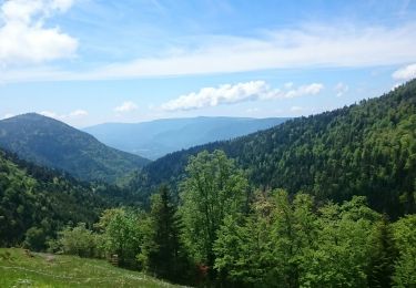
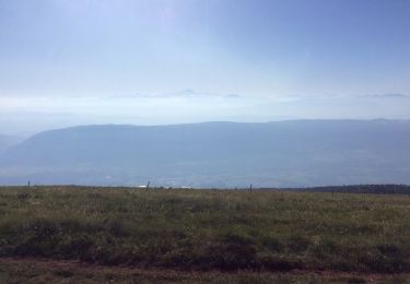
Au départ de la station de ski "Sur Lyand", une belle ballade par les crêtes (jamais vertigineux ni dangereux), avec le Mont-Blanc en face, jusqu'au Grand Colombier. Le final, en forêt, est parfois raide. Le retour, tranquille, se fait par l'ancienne chartreuse d'Arvière (site magnifique),transformée en maison forestière (très beau jardin de végétaux anciens). Cette ballade peut se faire en raquettes l'hiver.
Plaatsbepaling
Opmerkingen
Wandeltochten in de omgeving
![Tocht Stappen Corbonod - GRAND COLOMBIER: SUR LYAND - CHARBEMENES - CHALET D'ARVIERES - Photo](https://media.geolcdn.com/t/375/260/23de9000-aeb2-412c-a056-3c3ba2ac6100.jpg&format=jpg&maxdim=2)
![Stappen Stappen](https://static1.geolcdn.com/sitytour/trail-icons/101.png)
Stappen
![](/images/other/stat-length.png)
![](https://static1.geolcdn.com/siteimages/upload/files/16400158638029165_repeat_loop_refresh_sync_direction_icon.png)
![Tocht Stappen Arvière-en-Valromey - SUR LYAND NORD via corniche & balcon Valromey et GR9 - Photo](https://media.geolcdn.com/t/375/260/191d3346-6b07-4690-a9f2-9794339a2cee.jpg&format=jpg&maxdim=2)
![Stappen Stappen](https://static1.geolcdn.com/sitytour/trail-icons/101.png)
Stappen
![](/images/other/stat-length.png)
![](https://static1.geolcdn.com/siteimages/upload/files/16400158638029165_repeat_loop_refresh_sync_direction_icon.png)
![Tocht Stappen Motz - MOTZ SERRIERES: BORDS DU RHONE - Photo](https://media.geolcdn.com/t/375/260/d5979f91-e62c-40fa-96a4-fc46ef5f42b9.jpg&format=jpg&maxdim=2)
![Stappen Stappen](https://static1.geolcdn.com/sitytour/trail-icons/101.png)
Stappen
![](/images/other/stat-length.png)
![](https://static1.geolcdn.com/siteimages/upload/files/16400158638029165_repeat_loop_refresh_sync_direction_icon.png)
![Tocht Stappen Corbonod - GRAND COLOMBIER: SUR LYAND - CHARBEMENES par les crêtes - COLOMBIER - RETOUR PAR VALLON D'ARVIERES - Photo](https://media.geolcdn.com/t/375/260/b12dfb88-143c-4b4b-96de-73aa15f6023a.jpg&format=jpg&maxdim=2)
![Stappen Stappen](https://static1.geolcdn.com/sitytour/trail-icons/101.png)
Stappen
![](/images/other/stat-length.png)
![](https://static1.geolcdn.com/siteimages/upload/files/16400158638029165_repeat_loop_refresh_sync_direction_icon.png)
![Tocht Stappen Arvière-en-Valromey - Chalet d'Arvières - Photo](https://media.geolcdn.com/t/375/260/e14fe59e-874f-470f-857a-067bdc964819.jpg&format=jpg&maxdim=2)
![Stappen Stappen](https://static1.geolcdn.com/sitytour/trail-icons/101.png)
Stappen
![](/images/other/stat-length.png)
![](https://static1.geolcdn.com/siteimages/upload/files/16400158638029165_repeat_loop_refresh_sync_direction_icon.png)
![Tocht Stappen Arvière-en-Valromey - GR 9 - Étape 13 - Chalet d’Arvières - Chanaz - Photo](https://media.geolcdn.com/t/375/260/e124169d-20c4-4d49-b21c-03de29e41215.jpg&format=jpg&maxdim=2)
![Stappen Stappen](https://static1.geolcdn.com/sitytour/trail-icons/101.png)
Stappen
![](/images/other/stat-length.png)
![](https://static1.geolcdn.com/siteimages/upload/files/16400158638029165_repeat_loop_refresh_sync_direction_icon.png)
![Tocht Stappen Corbonod - combe merlin - Photo](https://media.geolcdn.com/t/375/260/ext.jpg?maxdim=2&url=https%3A%2F%2Fservices.sitytrail.com%2FGeolivesWS%2FDownloadMedia.ashx%3FTrailID%3D1046732%26Media%3Dfix__20180926124253.jpg)
![Stappen Stappen](https://static1.geolcdn.com/sitytour/trail-icons/101.png)
Stappen
![](/images/other/stat-length.png)
![](https://static1.geolcdn.com/siteimages/upload/files/16400158638029165_repeat_loop_refresh_sync_direction_icon.png)
![Tocht Stappen Arvière-en-Valromey - GTJ 13 Chalet d'Arviere/Culoz - Photo](https://media.geolcdn.com/t/375/260/95e569a8-40e4-4cb8-99dd-166dae94e18d.jpg&format=jpg&maxdim=2)
![Stappen Stappen](https://static1.geolcdn.com/sitytour/trail-icons/101.png)
Stappen
![](/images/other/stat-length.png)
![](https://static1.geolcdn.com/siteimages/upload/files/16400158638029165_repeat_loop_refresh_sync_direction_icon.png)
![Tocht Stappen Motz - Sentier Ornithologique du Fier - Photo](https://media.geolcdn.com/t/375/260/d4005703-68e3-471d-8360-fc8093f0f4a3.jpg&format=jpg&maxdim=2)
![Stappen Stappen](https://static1.geolcdn.com/sitytour/trail-icons/101.png)
Stappen
![](/images/other/stat-length.png)
![](https://static1.geolcdn.com/siteimages/upload/files/16400158638029165_repeat_loop_refresh_sync_direction_icon.png)