Tocht Stappen Le Boulou - Bataille du Boulou (66) - Photo
 sash28
sash28

Gebruiker

© OpenStreetMap contributors
Lengte
Lengte
13,1 km
Max. hoogte
Max. hoogte
200 m
Positief hoogteverschil
229 m
Km-Effort
Km-Effort  
16,2 km
Min. hoogte
Min. hoogte
84 m
Negatief hoogteverschil
229 m
Boucle
Boucle
Ja
Datum van aanmaak :
2014-12-10 00:00:00.0
Laatste wijziging :
2014-12-10 00:00:00.0

(0 Bericht)

Stappen
Stappen
4h00
Moeilijkheid : Medium

Scan deze QR-code om de tocht te openen in de SityTrail-applicatie

Gratisgps-wandelapplicatie

Logo SityTrail SityTrail

IGN / Geografische instituten

SityTrail uit de App Store downloaden SityTrail uit Google Play downloaden

Logo SityTrail SityTrail World

De wereld gaat voor u open

SityTrail uit de App Store downloaden SityTrail uit Google Play downloaden SityTrail op Huawei AppGallery downloaden

Over ons

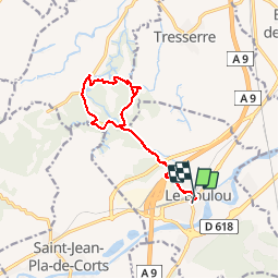
Tocht Stappen van 13,1 km beschikbaar op Occitanië, Pyrénées-Orientales, Le Boulou. Deze tocht wordt voorgesteld door sash28.

Beschrijving

Balade sur les traces de la bataille du Boulou qui a eu lieu en 1793-1794 entre Français et Espagnols. Des pancartes sont installées le long du parcours pour expliquer ce qu'il s'est passé.
Ce parcours est légèrement différent de celui proposé par l'office du tourisme du Boulou mais on arrive à la même chose! A vous de découvrir des chemins de traverse...

Hoogteprofiel

POI's

Plaatsbepaling

Land:
France
Regio :
Occitanië
Departement/Provincie :
Pyrénées-Orientales
Gemeente :
Le Boulou
Locatie:
Unknown
Vertrek:(Dec)
Vertrek:(UTM)
486181 ; 4708015 (31T) N.

Wandeltochten in de omgeving

Tocht Stappen Les Cluses - LES CLUSES 66 - Photo
Stappen
jeff66

Stappen

Gemakkelijk
(9)
Les Cluses, Occitanië, Pyrénées-Orientales, France
9,4 km | 12,8 km-effort
1h 50min
Ja
Tocht Stappen Saint-Jean-Pla-de-Corts - 66 ST-JEAN-PLA-DE-CORTS, promenade autour du Tech, jusqu'au BOULOU  - Photo
Stappen
jeff66

Stappen

Gemakkelijk
(1)
Saint-Jean-Pla-de-Corts, Occitanië, Pyrénées-Orientales, France
7,9 km | 8,8 km-effort
1h 18min
Ja
Tocht Stappen Montesquieu-des-Albères - MONTESQUIEU-DES-ALBERES 66 - Les Agouillous - les chemins de l'eau dans les Albères - Photo
Stappen
jeff66

Stappen

Medium
(1)
Montesquieu-des-Albères, Occitanië, Pyrénées-Orientales, France
12,7 km | 13,9 km-effort
2h 16min
Ja
Tocht Stappen Le Boulou - LES THERMES DU BOULOU - 66 - Albera viva - PUIG de l'Estella - Photo
Stappen
jeff66

Stappen

Medium
(2)
Le Boulou, Occitanië, Pyrénées-Orientales, France
7,3 km | 11,4 km-effort
1h 32min
Ja
Tocht Stappen Le Boulou - Bataille du Boulou (1793 - 1794) - Photo
Stappen
GUIDE
toutankhcarton

Stappen

Heel gemakkelijk
Le Boulou, Occitanië, Pyrénées-Orientales, France
10,4 km | 13,2 km-effort
1h 57min
Ja
Tocht Hybride fiets Le Boulou - Autour du Boulou (66) - Photo
Hybride fiets
GUIDE
toutankhcarton

Hybride fiets

Gemakkelijk
Le Boulou, Occitanië, Pyrénées-Orientales, France
17 km | 19,5 km-effort
1h 54min
Neen
Tocht Stappen Le Boulou - Pic Estelle (377m) - Le Boulou - Pyrénées orientales (66) - Photo
Stappen
GUIDE
toutankhcarton

Stappen

Heel gemakkelijk
Le Boulou, Occitanië, Pyrénées-Orientales, France
10,9 km | 15,9 km-effort
2h 19min
Ja
Tocht Stappen Les Cluses - LES CLUSES 66 - LE PERTHUS -  - Photo
Stappen
jeff66

Stappen

Medium
(2)
Les Cluses, Occitanië, Pyrénées-Orientales, France
14,4 km | 20 km-effort
2h 57min
Ja
Tocht Stappen Le Boulou - Le Boulou, chapelle saint Phillipe, mas d'en Conte - Photo
Stappen
nandaf

Stappen

Medium
(1)
Le Boulou, Occitanië, Pyrénées-Orientales, France
5,2 km | 7,6 km-effort
1h 43min
Ja


Sluiten
Mijn abonnementen