![](/images/other/stat-length.png)
![Tocht Mountainbike Chaumont - Corgebin_Ferme LaBorde_Neuilly sur Suize - Photo](https://media.geolcdn.com/t/1900/400/ext.pjpeg?maxdim=2&url=https%3A%2F%2Fstatic1.geolcdn.com%2Fsiteimages%2Fupload%2Ffiles%2F1524743154velo.jpg)
Corgebin_Ferme LaBorde_Neuilly sur Suize
piloiseau
Gebruiker
![Lengte](/images/other/stat-length.png)
Lengte
18 km
![Max. hoogte](https://static1.geolcdn.com/siteimages/upload/files/1508320355ic_sort_altitude_max_24dp.png)
Max. hoogte
369 m
![Positief hoogteverschil](https://static1.geolcdn.com/siteimages/upload/files/1508320355ic_sort_den_pos_24dp.png)
Positief hoogteverschil
246 m
![Km-Effort](/images/other/stat-length.png)
Km-Effort
21 km
![Min. hoogte](https://static1.geolcdn.com/siteimages/upload/files/1508320355ic_sort_altitude_min_24dp.png)
Min. hoogte
282 m
![Negatief hoogteverschil](https://static1.geolcdn.com/siteimages/upload/files/1508320355ic_sort_den_neg_24dp.png)
Negatief hoogteverschil
213 m
![Boucle](https://static1.geolcdn.com/siteimages/upload/files/16400158638029165_repeat_loop_refresh_sync_direction_icon.png)
Boucle
Neen
Datum van aanmaak :
2014-12-10 00:00:00.0
Laatste wijziging :
2014-12-10 00:00:00.0
![Mountainbike](https://static1.geolcdn.com/sitytour/trail-icons/202.png)
--
Moeilijkheid : Heel gemakkelijk
![Scan deze QR-code om de tocht te openen in de SityTrail-applicatie](https://capi.geolives.com/qq0zvz2zws4bq2lad0pu/sitytour/trails/134548/qr.png?size=200)
Gratisgps-wandelapplicatie
Over ons
Tocht Mountainbike van 18 km beschikbaar op Grand Est, Haute-Marne, Chaumont. Deze tocht wordt voorgesteld door piloiseau.
Beschrijving
Parcours facile. Attention par temps de chasse (du 28 Sept. au 28 Février si non modifiés) Repèrer l'entrée dans bois après la ferme : contourner un champ en revenant en arrière
Plaatsbepaling
Land:
France
Regio :
Grand Est
Departement/Provincie :
Haute-Marne
Gemeente :
Chaumont
Locatie:
Unknown
Vertrek:(Dec)
Vertrek:(UTM)
658193 ; 5329150 (31U) N.
Opmerkingen
Wandeltochten in de omgeving
![Tocht Stappen Chaumont - Boucle 31 km autour de Chaumont - Photo](https://media.geolcdn.com/t/375/260/cbc46c4d-5909-46e1-804f-dfb6d68e47a3.jpg&format=jpg&maxdim=2)
![Stappen Stappen](https://static1.geolcdn.com/sitytour/trail-icons/101.png)
Boucle 31 km autour de Chaumont
Stappen
Zeer moeilijk
Chaumont,
Grand Est,
Haute-Marne,
France
![](/images/other/stat-length.png)
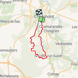
31 km | 36 km-effort
6h 35min
![](https://static1.geolcdn.com/siteimages/upload/files/16400158638029165_repeat_loop_refresh_sync_direction_icon.png)
Ja
![Tocht Stappen Chaumont - la vendue-chaumont01 - Photo](https://media.geolcdn.com/t/375/260/ext.jpg?maxdim=2&url=https%3A%2F%2Fstatic1.geolcdn.com%2Fsiteimages%2Fupload%2Ffiles%2F1553511878bg_sport_marche.png)
![Stappen Stappen](https://static1.geolcdn.com/sitytour/trail-icons/101.png)
la vendue-chaumont01
Stappen
Gemakkelijk
(1)
Chaumont,
Grand Est,
Haute-Marne,
France
![](/images/other/stat-length.png)
8,7 km | 10,2 km-effort
1h 55min
![](https://static1.geolcdn.com/siteimages/upload/files/16400158638029165_repeat_loop_refresh_sync_direction_icon.png)
Ja
![Tocht Mountainbike Chaumont - Corgebin Ferme_La_Borde Neuilly s/ Suize - Photo](https://media.geolcdn.com/t/375/260/ext.jpg?maxdim=2&url=https%3A%2F%2Fstatic1.geolcdn.com%2Fsiteimages%2Fupload%2Ffiles%2F1524743154velo.jpg)
![Mountainbike Mountainbike](https://static1.geolcdn.com/sitytour/trail-icons/202.png)
Corgebin Ferme_La_Borde Neuilly s/ Suize
Mountainbike
Heel gemakkelijk
(1)
Chaumont,
Grand Est,
Haute-Marne,
France
![](/images/other/stat-length.png)
20 km | 24 km-effort
Onbekend
![](https://static1.geolcdn.com/siteimages/upload/files/16400158638029165_repeat_loop_refresh_sync_direction_icon.png)
Ja
![Tocht Stappen Chaumont - Le Corgebin 8,5km - Photo](https://media.geolcdn.com/t/375/260/ext.jpg?maxdim=2&url=https%3A%2F%2Fstatic1.geolcdn.com%2Fsiteimages%2Fupload%2Ffiles%2F1553511878bg_sport_marche.png)
![Stappen Stappen](https://static1.geolcdn.com/sitytour/trail-icons/101.png)
Le Corgebin 8,5km
Stappen
Medium
(1)
Chaumont,
Grand Est,
Haute-Marne,
France
![](/images/other/stat-length.png)
8,3 km | 9,9 km-effort
2h 15min
![](https://static1.geolcdn.com/siteimages/upload/files/16400158638029165_repeat_loop_refresh_sync_direction_icon.png)
Ja
![Tocht Noords wandelen Chaumont - marche nordique AJPC philippe - Photo](https://media.geolcdn.com/t/375/260/ext.jpg?maxdim=2&url=https%3A%2F%2Fstatic1.geolcdn.com%2Fsiteimages%2Fupload%2Ffiles%2F1545311037marcheuse_200dpi.jpg)
![Noords wandelen Noords wandelen](https://static1.geolcdn.com/sitytour/trail-icons/102.png)
marche nordique AJPC philippe
Noords wandelen
Medium
(1)
Chaumont,
Grand Est,
Haute-Marne,
France
![](/images/other/stat-length.png)
9,3 km | 10,9 km-effort
1h 58min
![](https://static1.geolcdn.com/siteimages/upload/files/16400158638029165_repeat_loop_refresh_sync_direction_icon.png)
Ja
![Tocht Stappen Chaumont - Chaumont centre-Verbiesles-Ville aux bois-Chaumont - Photo](https://media.geolcdn.com/t/375/260/e2fab6d3-c0c5-465c-b883-2870626abdcf.jpg&format=jpg&maxdim=2)
![Stappen Stappen](https://static1.geolcdn.com/sitytour/trail-icons/101.png)
Chaumont centre-Verbiesles-Ville aux bois-Chaumont
Stappen
Moeilijk
Chaumont,
Grand Est,
Haute-Marne,
France
![](/images/other/stat-length.png)
21 km | 24 km-effort
4h 18min
![](https://static1.geolcdn.com/siteimages/upload/files/16400158638029165_repeat_loop_refresh_sync_direction_icon.png)
Ja
![Tocht Mountainbike Chaumont - Corgebin 24 11 2019 - Photo](https://media.geolcdn.com/t/375/260/ext.jpg?maxdim=2&url=https%3A%2F%2Fstatic1.geolcdn.com%2Fsiteimages%2Fupload%2Ffiles%2F1524743154velo.jpg)
![Mountainbike Mountainbike](https://static1.geolcdn.com/sitytour/trail-icons/202.png)
Corgebin 24 11 2019
Mountainbike
(1)
Chaumont,
Grand Est,
Haute-Marne,
France
![](/images/other/stat-length.png)
26 km | 31 km-effort
3h 9min
![](https://static1.geolcdn.com/siteimages/upload/files/16400158638029165_repeat_loop_refresh_sync_direction_icon.png)
Ja
![Tocht Noords wandelen Chaumont - Chaumont, val barizien, st rock - Photo](https://media.geolcdn.com/t/375/260/79111c5e-b624-42e6-9ef9-dbc4890443a5.jpg&format=jpg&maxdim=2)
![Noords wandelen Noords wandelen](https://static1.geolcdn.com/sitytour/trail-icons/102.png)
Chaumont, val barizien, st rock
Noords wandelen
Heel gemakkelijk
Chaumont,
Grand Est,
Haute-Marne,
France
![](/images/other/stat-length.png)
7,7 km | 9,6 km-effort
1h 36min
![](https://static1.geolcdn.com/siteimages/upload/files/16400158638029165_repeat_loop_refresh_sync_direction_icon.png)
Ja
![Tocht Stappen Chaumont - rando galette 2024 des 1000 pattes - Photo](https://media.geolcdn.com/t/375/260/fe9ebe3d-2fc4-4369-b108-240006ae6822.jpg&format=jpg&maxdim=2)
![Stappen Stappen](https://static1.geolcdn.com/sitytour/trail-icons/101.png)
rando galette 2024 des 1000 pattes
Stappen
Gemakkelijk
Chaumont,
Grand Est,
Haute-Marne,
France
![](/images/other/stat-length.png)
6,8 km | 8,4 km-effort
1h 57min
![](https://static1.geolcdn.com/siteimages/upload/files/16400158638029165_repeat_loop_refresh_sync_direction_icon.png)
Ja