![](/images/other/stat-length.png)
![Tocht Stappen Étival-lès-le-Mans - etivale les le mans - Photo](https://media.geolcdn.com/t/1900/400/ext.pjpeg?maxdim=2&url=https%3A%2F%2Fstatic1.geolcdn.com%2Fsiteimages%2Fupload%2Ffiles%2F1553511878bg_sport_marche.png)
etivale les le mans
yoyozen
Gebruiker
![Lengte](/images/other/stat-length.png)
Lengte
7,3 km
![Max. hoogte](https://static1.geolcdn.com/siteimages/upload/files/1508320355ic_sort_altitude_max_24dp.png)
Max. hoogte
92 m
![Positief hoogteverschil](https://static1.geolcdn.com/siteimages/upload/files/1508320355ic_sort_den_pos_24dp.png)
Positief hoogteverschil
77 m
![Km-Effort](/images/other/stat-length.png)
Km-Effort
8,3 km
![Min. hoogte](https://static1.geolcdn.com/siteimages/upload/files/1508320355ic_sort_altitude_min_24dp.png)
Min. hoogte
53 m
![Negatief hoogteverschil](https://static1.geolcdn.com/siteimages/upload/files/1508320355ic_sort_den_neg_24dp.png)
Negatief hoogteverschil
77 m
![Boucle](https://static1.geolcdn.com/siteimages/upload/files/16400158638029165_repeat_loop_refresh_sync_direction_icon.png)
Boucle
Ja
Datum van aanmaak :
2014-12-10 00:00:00.0
Laatste wijziging :
2014-12-10 00:00:00.0
![Stappen](https://static1.geolcdn.com/sitytour/trail-icons/101.png)
1h30
Moeilijkheid : Gemakkelijk
![Scan deze QR-code om de tocht te openen in de SityTrail-applicatie](https://capi.geolives.com/qq0zvz2zws4bq2lad0pu/sitytour/trails/131858/qr.png?size=200)
Gratisgps-wandelapplicatie
Over ons
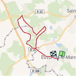
Tocht Stappen van 7,3 km beschikbaar op Pays de la Loire, Sarthe, Étival-lès-le-Mans. Deze tocht wordt voorgesteld door yoyozen.
Beschrijving
Boucle du bois de la cornuère tiré du guide Vallée de la sarthe
temp estimé 1h 30
Plaatsbepaling
Land:
France
Regio :
Pays de la Loire
Departement/Provincie :
Sarthe
Gemeente :
Étival-lès-le-Mans
Locatie:
Unknown
Vertrek:(Dec)
Vertrek:(UTM)
282519 ; 5315347 (31T) N.
Opmerkingen
Wandeltochten in de omgeving
![Tocht Mountainbike Pruillé-le-Chétif - Saint George du Bois - Pruillé le Chétif - Photo](https://media.geolcdn.com/t/375/260/ext.jpg?maxdim=2&url=https%3A%2F%2Fstatic1.geolcdn.com%2Fsiteimages%2Fupload%2Ffiles%2F1524743154velo.jpg)
![Mountainbike Mountainbike](https://static1.geolcdn.com/sitytour/trail-icons/202.png)
Saint George du Bois - Pruillé le Chétif
Mountainbike
Medium
(1)
Pruillé-le-Chétif,
Pays de la Loire,
Sarthe,
France
![](/images/other/stat-length.png)
21 km | 24 km-effort
1h 30min
![](https://static1.geolcdn.com/siteimages/upload/files/16400158638029165_repeat_loop_refresh_sync_direction_icon.png)
Ja
![Tocht Noords wandelen Pruillé-le-Chétif - SityTrail - Pruillé-le-Chétif - Photo](https://media.geolcdn.com/t/375/260/ext.jpg?maxdim=2&url=https%3A%2F%2Fstatic1.geolcdn.com%2Fsiteimages%2Fupload%2Ffiles%2F1545311037marcheuse_200dpi.jpg)
![Noords wandelen Noords wandelen](https://static1.geolcdn.com/sitytour/trail-icons/102.png)
SityTrail - Pruillé-le-Chétif
Noords wandelen
Heel gemakkelijk
Pruillé-le-Chétif,
Pays de la Loire,
Sarthe,
France
![](/images/other/stat-length.png)
10,9 km | 12,9 km-effort
Onbekend
![](https://static1.geolcdn.com/siteimages/upload/files/16400158638029165_repeat_loop_refresh_sync_direction_icon.png)
Ja
![Tocht Stappen Pruillé-le-Chétif - Pruillé-le-Chétif - Photo](https://media.geolcdn.com/t/375/260/ext.jpg?maxdim=2&url=https%3A%2F%2Fstatic1.geolcdn.com%2Fsiteimages%2Fupload%2Ffiles%2F1553511878bg_sport_marche.png)
![Stappen Stappen](https://static1.geolcdn.com/sitytour/trail-icons/101.png)
Pruillé-le-Chétif
Stappen
Heel gemakkelijk
Pruillé-le-Chétif,
Pays de la Loire,
Sarthe,
France
![](/images/other/stat-length.png)
10,9 km | 12,9 km-effort
2h 49min
![](https://static1.geolcdn.com/siteimages/upload/files/16400158638029165_repeat_loop_refresh_sync_direction_icon.png)
Ja
![Tocht Mountainbike Étival-lès-le-Mans - Etival-Voivres-Allonnes - Photo](https://media.geolcdn.com/t/375/260/ext.jpg?maxdim=2&url=https%3A%2F%2Fstatic1.geolcdn.com%2Fsiteimages%2Fupload%2Ffiles%2F1524743154velo.jpg)
![Mountainbike Mountainbike](https://static1.geolcdn.com/sitytour/trail-icons/202.png)
Etival-Voivres-Allonnes
Mountainbike
Medium
(1)
Étival-lès-le-Mans,
Pays de la Loire,
Sarthe,
France
![](/images/other/stat-length.png)
32 km | 35 km-effort
2h 21min
![](https://static1.geolcdn.com/siteimages/upload/files/16400158638029165_repeat_loop_refresh_sync_direction_icon.png)
Ja
![Tocht Stappen Voivres-lès-le-Mans - voivre les le mans - Photo](https://media.geolcdn.com/t/375/260/ext.jpg?maxdim=2&url=https%3A%2F%2Fstatic1.geolcdn.com%2Fsiteimages%2Fupload%2Ffiles%2F1553511878bg_sport_marche.png)
![Stappen Stappen](https://static1.geolcdn.com/sitytour/trail-icons/101.png)
voivre les le mans
Stappen
Heel gemakkelijk
Voivres-lès-le-Mans,
Pays de la Loire,
Sarthe,
France
![](/images/other/stat-length.png)
6,9 km | 7,7 km-effort
1h 47min
![](https://static1.geolcdn.com/siteimages/upload/files/16400158638029165_repeat_loop_refresh_sync_direction_icon.png)
Ja
![Tocht Noords wandelen Pruillé-le-Chétif - Pruillé le chétif Réalisé - Photo](https://media.geolcdn.com/t/375/260/ext.jpg?maxdim=2&url=https%3A%2F%2Fstatic1.geolcdn.com%2Fsiteimages%2Fupload%2Ffiles%2F1545311037marcheuse_200dpi.jpg)
![Noords wandelen Noords wandelen](https://static1.geolcdn.com/sitytour/trail-icons/102.png)
Pruillé le chétif Réalisé
Noords wandelen
Gemakkelijk
Pruillé-le-Chétif,
Pays de la Loire,
Sarthe,
France
![](/images/other/stat-length.png)
7,5 km | 8,6 km-effort
1h 50min
![](https://static1.geolcdn.com/siteimages/upload/files/16400158638029165_repeat_loop_refresh_sync_direction_icon.png)
Ja
![Tocht Paardrijden Allonnes - Vallon Juigné - Photo](https://media.geolcdn.com/t/375/260/ext.jpg?maxdim=2&url=https%3A%2F%2Fstatic1.geolcdn.com%2Fsiteimages%2Fupload%2Ffiles%2F1524743154cheval.jpg)
![Paardrijden Paardrijden](https://static1.geolcdn.com/sitytour/trail-icons/301.png)
Vallon Juigné
Paardrijden
Gemakkelijk
Allonnes,
Pays de la Loire,
Sarthe,
France
![](/images/other/stat-length.png)
6,6 km | 7,3 km-effort
58min
![](https://static1.geolcdn.com/siteimages/upload/files/16400158638029165_repeat_loop_refresh_sync_direction_icon.png)
Neen
![Tocht Noords wandelen Pruillé-le-Chétif - pruillé - Photo](https://media.geolcdn.com/t/375/260/ext.jpg?maxdim=2&url=https%3A%2F%2Fstatic1.geolcdn.com%2Fsiteimages%2Fupload%2Ffiles%2F1545311037marcheuse_200dpi.jpg)
![Noords wandelen Noords wandelen](https://static1.geolcdn.com/sitytour/trail-icons/102.png)
pruillé
Noords wandelen
Heel gemakkelijk
(1)
Pruillé-le-Chétif,
Pays de la Loire,
Sarthe,
France
![](/images/other/stat-length.png)
7 km | 8,5 km-effort
1h 39min
![](https://static1.geolcdn.com/siteimages/upload/files/16400158638029165_repeat_loop_refresh_sync_direction_icon.png)
Ja
![Tocht sport Saint-Georges-du-Bois - Saint-georges du bois - Photo](https://media.geolcdn.com/t/375/260/ext.jpg?maxdim=2&url=https%3A%2F%2Fsecurestorage.geolives.com%2Fsitytour%2Ftrail-bg%2Fdefault.jpg)
Saint-georges du bois
sport
Heel gemakkelijk
Saint-Georges-du-Bois,
Pays de la Loire,
Sarthe,
France
![](/images/other/stat-length.png)
8,8 km | 10,4 km-effort
Onbekend
![](https://static1.geolcdn.com/siteimages/upload/files/16400158638029165_repeat_loop_refresh_sync_direction_icon.png)
Ja