![](/images/other/stat-length.png)
![Tocht Stappen Valentine - bout du puy - Photo](https://media.geolcdn.com/t/1900/400/ext.pjpeg?maxdim=2&url=https%3A%2F%2Fservices.sitytrail.com%2FGeolivesWS%2FDownloadMedia.ashx%3FTrailID%3D130088%26Media%3D20120525131819.jpg)
bout du puy
yoyo31
Gebruiker
![Lengte](/images/other/stat-length.png)
Lengte
4,3 km
![Max. hoogte](https://static1.geolcdn.com/siteimages/upload/files/1508320355ic_sort_altitude_max_24dp.png)
Max. hoogte
540 m
![Positief hoogteverschil](https://static1.geolcdn.com/siteimages/upload/files/1508320355ic_sort_den_pos_24dp.png)
Positief hoogteverschil
182 m
![Km-Effort](/images/other/stat-length.png)
Km-Effort
6,8 km
![Min. hoogte](https://static1.geolcdn.com/siteimages/upload/files/1508320355ic_sort_altitude_min_24dp.png)
Min. hoogte
362 m
![Negatief hoogteverschil](https://static1.geolcdn.com/siteimages/upload/files/1508320355ic_sort_den_neg_24dp.png)
Negatief hoogteverschil
183 m
![Boucle](https://static1.geolcdn.com/siteimages/upload/files/16400158638029165_repeat_loop_refresh_sync_direction_icon.png)
Boucle
Ja
Datum van aanmaak :
2014-12-10 00:00:00.0
Laatste wijziging :
2014-12-10 00:00:00.0
![Stappen](https://static1.geolcdn.com/sitytour/trail-icons/101.png)
1h07
Moeilijkheid : Gemakkelijk
![Scan deze QR-code om de tocht te openen in de SityTrail-applicatie](https://capi.geolives.com/qq0zvz2zws4bq2lad0pu/sitytour/trails/130088/qr.png?size=200)
Gratisgps-wandelapplicatie
Over ons
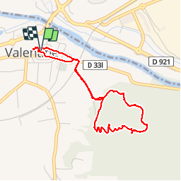
Tocht Stappen van 4,3 km beschikbaar op Occitanië, Haute-Garonne, Valentine. Deze tocht wordt voorgesteld door yoyo31.
Beschrijving
Rando courte à pies départ de Valentine pour monter au bout du puy par les bois plutôt boisée manque de passage mes acsecible rando agréable
Plaatsbepaling
Land:
France
Regio :
Occitanië
Departement/Provincie :
Haute-Garonne
Gemeente :
Valentine
Locatie:
Unknown
Vertrek:(Dec)
Vertrek:(UTM)
313264 ; 4773923 (31T) N.
Opmerkingen
Wandeltochten in de omgeving
![Tocht Stappen Saint-Gaudens - Via Garonna - Photo](https://media.geolcdn.com/t/375/260/06ef0e7f-9e3c-48de-946f-6ff47dcacef6.jpg&format=jpg&maxdim=2)
![Stappen Stappen](https://static1.geolcdn.com/sitytour/trail-icons/101.png)
Via Garonna
Stappen
Medium
Saint-Gaudens,
Occitanië,
Haute-Garonne,
France
![](/images/other/stat-length.png)
25 km | 30 km-effort
6h 23min
![](https://static1.geolcdn.com/siteimages/upload/files/16400158638029165_repeat_loop_refresh_sync_direction_icon.png)
Neen
![Tocht Stappen Labarthe-Rivière - Camon - Photo](https://media.geolcdn.com/t/375/260/2823319f-a70a-4510-8f39-12192505a5db.jpg&format=jpg&maxdim=2)
![Stappen Stappen](https://static1.geolcdn.com/sitytour/trail-icons/101.png)
Camon
Stappen
Gemakkelijk
Labarthe-Rivière,
Occitanië,
Haute-Garonne,
France
![](/images/other/stat-length.png)
7,5 km | 8 km-effort
1h 40min
![](https://static1.geolcdn.com/siteimages/upload/files/16400158638029165_repeat_loop_refresh_sync_direction_icon.png)
Ja
![Tocht Stappen Valentine - bout du puy - Photo](https://media.geolcdn.com/t/375/260/ext.jpg?maxdim=2&url=https%3A%2F%2Fservices.sitytrail.com%2FGeolivesWS%2FDownloadMedia.ashx%3FTrailID%3D130087%26Media%3D20120525131819.jpg)
![Stappen Stappen](https://static1.geolcdn.com/sitytour/trail-icons/101.png)
bout du puy
Stappen
Gemakkelijk
Valentine,
Occitanië,
Haute-Garonne,
France
![](/images/other/stat-length.png)
4,3 km | 6,8 km-effort
1h 7min
![](https://static1.geolcdn.com/siteimages/upload/files/16400158638029165_repeat_loop_refresh_sync_direction_icon.png)
Ja
![Tocht Mountainbike Encausse-les-Thermes - Espace VTT FFC Pyrénées Comminges - n° 21 Balade Encaussaise - Photo](https://media.geolcdn.com/t/375/260/ext.jpg?maxdim=2&url=https%3A%2F%2Fservices.sitytrail.com%2FGeolivesWS%2FDownloadMedia.ashx%3FTrailID%3D101789%26Media%3D2063_1.jpg)
![Mountainbike Mountainbike](https://static1.geolcdn.com/sitytour/trail-icons/202.png)
Espace VTT FFC Pyrénées Comminges - n° 21 Balade Encaussaise
Mountainbike
Gemakkelijk
Encausse-les-Thermes,
Occitanië,
Haute-Garonne,
France
![](/images/other/stat-length.png)
8,7 km | 9,7 km-effort
1h 0min
![](https://static1.geolcdn.com/siteimages/upload/files/16400158638029165_repeat_loop_refresh_sync_direction_icon.png)
Ja
![Tocht Wegfiets Villeneuve-de-Rivière - boucle au départ de Villeneuve de riviere - Photo](https://media.geolcdn.com/t/375/260/ext.jpg?maxdim=2&url=https%3A%2F%2Fstatic1.geolcdn.com%2Fsiteimages%2Fupload%2Ffiles%2F1524743154velo.jpg)
![Wegfiets Wegfiets](https://static1.geolcdn.com/sitytour/trail-icons/201.png)
boucle au départ de Villeneuve de riviere
Wegfiets
Medium
Villeneuve-de-Rivière,
Occitanië,
Haute-Garonne,
France
![](/images/other/stat-length.png)
61 km | 71 km-effort
3h 55min
![](https://static1.geolcdn.com/siteimages/upload/files/16400158638029165_repeat_loop_refresh_sync_direction_icon.png)
Ja
![Tocht Stappen Aspret-Sarrat - Aspret-Sarrat - Photo](https://media.geolcdn.com/t/375/260/b648ff4d-f574-426a-bb6d-42f1facf98f2.jpg&format=jpg&maxdim=2)
![Stappen Stappen](https://static1.geolcdn.com/sitytour/trail-icons/101.png)
Aspret-Sarrat
Stappen
Gemakkelijk
Aspret-Sarrat,
Occitanië,
Haute-Garonne,
France
![](/images/other/stat-length.png)
4,3 km | 5,5 km-effort
1h 14min
![](https://static1.geolcdn.com/siteimages/upload/files/16400158638029165_repeat_loop_refresh_sync_direction_icon.png)
Ja
![Tocht Stappen Ardiège - Ardiege, Cap de Rouzet nouveau chemin de parapente avec des gens - Photo](https://media.geolcdn.com/t/375/260/5b60187f-a4cb-41a1-928a-bff5f63f8cb7.jpg&format=jpg&maxdim=2)
![Stappen Stappen](https://static1.geolcdn.com/sitytour/trail-icons/101.png)
Ardiege, Cap de Rouzet nouveau chemin de parapente avec des gens
Stappen
Medium
Ardiège,
Occitanië,
Haute-Garonne,
France
![](/images/other/stat-length.png)
6,1 km | 10,6 km-effort
2h 50min
![](https://static1.geolcdn.com/siteimages/upload/files/16400158638029165_repeat_loop_refresh_sync_direction_icon.png)
Ja
![Tocht Stappen Ardiège - Depart Ardiege cap de la picote ,crete de Huntous,les arrousses plombières 2 le 06 Mars 2024 avec eve - Photo](https://media.geolcdn.com/t/375/260/e8a93abc-d169-4739-a856-df84bb241b2b.jpg&format=jpg&maxdim=2)
![Stappen Stappen](https://static1.geolcdn.com/sitytour/trail-icons/101.png)
Depart Ardiege cap de la picote ,crete de Huntous,les arrousses plombières 2 ...
Stappen
Medium
Ardiège,
Occitanië,
Haute-Garonne,
France
![](/images/other/stat-length.png)
9,1 km | 14,2 km-effort
3h 15min
![](https://static1.geolcdn.com/siteimages/upload/files/16400158638029165_repeat_loop_refresh_sync_direction_icon.png)
Ja
![Tocht Wegfiets Villeneuve-de-Rivière - boucle dans le Comminges - Photo](https://media.geolcdn.com/t/375/260/ext.jpg?maxdim=2&url=https%3A%2F%2Fstatic1.geolcdn.com%2Fsiteimages%2Fupload%2Ffiles%2F1524743154velo.jpg)
![Wegfiets Wegfiets](https://static1.geolcdn.com/sitytour/trail-icons/201.png)
boucle dans le Comminges
Wegfiets
Medium
Villeneuve-de-Rivière,
Occitanië,
Haute-Garonne,
France
![](/images/other/stat-length.png)
68 km | 80 km-effort
3h 58min
![](https://static1.geolcdn.com/siteimages/upload/files/16400158638029165_repeat_loop_refresh_sync_direction_icon.png)
Neen