![](/images/other/stat-length.png)
![Tocht Stappen Boubers-sur-Canche - 7 km autour de Boubers sur Canche - Photo](https://media.geolcdn.com/t/1900/400/ext.pjpeg?maxdim=2&url=https%3A%2F%2Fservices.sitytrail.com%2FGeolivesWS%2FDownloadMedia.ashx%3FTrailID%3D129842%26Media%3D13395_5.jpg)
7 km autour de Boubers sur Canche
tracegps
Gebruiker
![Lengte](/images/other/stat-length.png)
Lengte
6,8 km
![Max. hoogte](https://static1.geolcdn.com/siteimages/upload/files/1508320355ic_sort_altitude_max_24dp.png)
Max. hoogte
126 m
![Positief hoogteverschil](https://static1.geolcdn.com/siteimages/upload/files/1508320355ic_sort_den_pos_24dp.png)
Positief hoogteverschil
88 m
![Km-Effort](/images/other/stat-length.png)
Km-Effort
7,9 km
![Min. hoogte](https://static1.geolcdn.com/siteimages/upload/files/1508320355ic_sort_altitude_min_24dp.png)
Min. hoogte
54 m
![Negatief hoogteverschil](https://static1.geolcdn.com/siteimages/upload/files/1508320355ic_sort_den_neg_24dp.png)
Negatief hoogteverschil
90 m
![Boucle](https://static1.geolcdn.com/siteimages/upload/files/16400158638029165_repeat_loop_refresh_sync_direction_icon.png)
Boucle
Ja
Datum van aanmaak :
2014-12-10 00:00:00.0
Laatste wijziging :
2014-12-10 00:00:00.0
![Stappen](https://static1.geolcdn.com/sitytour/trail-icons/101.png)
1h40
Moeilijkheid : Gemakkelijk
![Scan deze QR-code om de tocht te openen in de SityTrail-applicatie](https://capi.geolives.com/qq0zvz2zws4bq2lad0pu/sitytour/trails/129842/qr.png?size=200)
Gratisgps-wandelapplicatie
Over ons
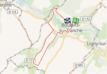
Tocht Stappen van 6,8 km beschikbaar op Hauts-de-France, Pas-de-Calais, Boubers-sur-Canche. Deze tocht wordt voorgesteld door tracegps.
Beschrijving
Circuit proposé par la commune de Boubers sur Canche. Départ du parking de l'église, place du Général de Gaulle.
Plaatsbepaling
Land:
France
Regio :
Hauts-de-France
Departement/Provincie :
Pas-de-Calais
Gemeente :
Boubers-sur-Canche
Locatie:
Unknown
Vertrek:(Dec)
Vertrek:(UTM)
445686 ; 5571291 (31U) N.
Opmerkingen
Wandeltochten in de omgeving
![Tocht Stappen Ligny-sur-Canche - LIGNY SUR CANCHE - Le fond de Boubers - Photo](https://media.geolcdn.com/t/375/260/4b8325fc-19bd-4d26-8c41-86cfc4b87521.jpg&format=jpg&maxdim=2)
![Stappen Stappen](https://static1.geolcdn.com/sitytour/trail-icons/101.png)
LIGNY SUR CANCHE - Le fond de Boubers
Stappen
Moeilijk
Ligny-sur-Canche,
Hauts-de-France,
Pas-de-Calais,
France
![](/images/other/stat-length.png)
10,7 km | 12,7 km-effort
2h 52min
![](https://static1.geolcdn.com/siteimages/upload/files/16400158638029165_repeat_loop_refresh_sync_direction_icon.png)
Ja
![Tocht Te voet Bonnières - BONNIERES (62) - Les éoliennes - Photo](https://media.geolcdn.com/t/375/260/005a97a0-8707-4ea4-9c25-24284e6b14f7.jpg&format=jpg&maxdim=2)
![Te voet Te voet](https://static1.geolcdn.com/sitytour/trail-icons/100.png)
BONNIERES (62) - Les éoliennes
Te voet
Gemakkelijk
Bonnières,
Hauts-de-France,
Pas-de-Calais,
France
![](/images/other/stat-length.png)
15,2 km | 16,9 km-effort
3h 50min
![](https://static1.geolcdn.com/siteimages/upload/files/16400158638029165_repeat_loop_refresh_sync_direction_icon.png)
Ja
![Tocht Stappen Blangerval-Blangermont - Blangermont - Photo](https://media.geolcdn.com/t/375/260/338df122-5cfa-4d07-a35d-1953cd4ed4c4.jpg&format=jpg&maxdim=2)
![Stappen Stappen](https://static1.geolcdn.com/sitytour/trail-icons/101.png)
Blangermont
Stappen
Medium
Blangerval-Blangermont,
Hauts-de-France,
Pas-de-Calais,
France
![](/images/other/stat-length.png)
14,2 km | 16,4 km-effort
3h 21min
![](https://static1.geolcdn.com/siteimages/upload/files/16400158638029165_repeat_loop_refresh_sync_direction_icon.png)
Ja
![Tocht Andere activiteiten Frévent - Nord - Pas-de-Calais - Ligne 305 - Saint-Roch - Frévent - Photo](https://media.geolcdn.com/t/375/260/ext.jpg?maxdim=2&url=https%3A%2F%2Fstatic1.geolcdn.com%2Fsiteimages%2Fupload%2Ffiles%2F1545311037marcheuse_200dpi.jpg)
![Andere activiteiten Andere activiteiten](https://static1.geolcdn.com/sitytour/trail-icons/900.png)
Nord - Pas-de-Calais - Ligne 305 - Saint-Roch - Frévent
Andere activiteiten
Heel gemakkelijk
Frévent,
Hauts-de-France,
Pas-de-Calais,
France
![](/images/other/stat-length.png)
11 km | 12,4 km-effort
5min
![](https://static1.geolcdn.com/siteimages/upload/files/16400158638029165_repeat_loop_refresh_sync_direction_icon.png)
Neen
![Tocht Stappen Frévent - FREVENT - Photo](https://media.geolcdn.com/t/375/260/ext.jpg?maxdim=2&url=https%3A%2F%2Fstatic1.geolcdn.com%2Fsiteimages%2Fupload%2Ffiles%2F1553511878bg_sport_marche.png)
![Stappen Stappen](https://static1.geolcdn.com/sitytour/trail-icons/101.png)
FREVENT
Stappen
Medium
Frévent,
Hauts-de-France,
Pas-de-Calais,
France
![](/images/other/stat-length.png)
27 km | 31 km-effort
6h 42min
![](https://static1.geolcdn.com/siteimages/upload/files/16400158638029165_repeat_loop_refresh_sync_direction_icon.png)
Ja
![Tocht Stappen Frévent - Rando Frevent 16 km - Photo](https://media.geolcdn.com/t/375/260/ext.jpg?maxdim=2&url=https%3A%2F%2Fstatic1.geolcdn.com%2Fsiteimages%2Fupload%2Ffiles%2F1553511878bg_sport_marche.png)
![Stappen Stappen](https://static1.geolcdn.com/sitytour/trail-icons/101.png)
Rando Frevent 16 km
Stappen
Moeilijk
Frévent,
Hauts-de-France,
Pas-de-Calais,
France
![](/images/other/stat-length.png)
15,9 km | 18,4 km-effort
4h 11min
![](https://static1.geolcdn.com/siteimages/upload/files/16400158638029165_repeat_loop_refresh_sync_direction_icon.png)
Ja
![Tocht Stappen Frévent - Frévent (3) 23.5Kms Dén P 319m - Photo](https://media.geolcdn.com/t/375/260/ext.jpg?maxdim=2&url=https%3A%2F%2Fstatic1.geolcdn.com%2Fsiteimages%2Fupload%2Ffiles%2F1553511878bg_sport_marche.png)
![Stappen Stappen](https://static1.geolcdn.com/sitytour/trail-icons/101.png)
Frévent (3) 23.5Kms Dén P 319m
Stappen
Zeer moeilijk
Frévent,
Hauts-de-France,
Pas-de-Calais,
France
![](/images/other/stat-length.png)
24 km | 28 km-effort
6h 4min
![](https://static1.geolcdn.com/siteimages/upload/files/16400158638029165_repeat_loop_refresh_sync_direction_icon.png)
Ja