![](/images/other/stat-length.png)
![Tocht Stappen Laruns - Pic Lavigne - Pic de Chérue - Pic Saoubiste - Photo](https://media.geolcdn.com/t/1900/400/ext.pjpeg?maxdim=2&url=https%3A%2F%2Fstatic1.geolcdn.com%2Fsiteimages%2Fupload%2Ffiles%2F1553511878bg_sport_marche.png)
Pic Lavigne - Pic de Chérue - Pic Saoubiste
tracegps
Gebruiker
![Lengte](/images/other/stat-length.png)
Lengte
13,7 km
![Max. hoogte](https://static1.geolcdn.com/siteimages/upload/files/1508320355ic_sort_altitude_max_24dp.png)
Max. hoogte
2224 m
![Positief hoogteverschil](https://static1.geolcdn.com/siteimages/upload/files/1508320355ic_sort_den_pos_24dp.png)
Positief hoogteverschil
1015 m
![Km-Effort](/images/other/stat-length.png)
Km-Effort
27 km
![Min. hoogte](https://static1.geolcdn.com/siteimages/upload/files/1508320355ic_sort_altitude_min_24dp.png)
Min. hoogte
1432 m
![Negatief hoogteverschil](https://static1.geolcdn.com/siteimages/upload/files/1508320355ic_sort_den_neg_24dp.png)
Negatief hoogteverschil
1013 m
![Boucle](https://static1.geolcdn.com/siteimages/upload/files/16400158638029165_repeat_loop_refresh_sync_direction_icon.png)
Boucle
Ja
Datum van aanmaak :
2014-12-10 00:00:00.0
Laatste wijziging :
2014-12-10 00:00:00.0
![Stappen](https://static1.geolcdn.com/sitytour/trail-icons/101.png)
4h45
Moeilijkheid : Zeer moeilijk
![Scan deze QR-code om de tocht te openen in de SityTrail-applicatie](https://capi.geolives.com/qq0zvz2zws4bq2lad0pu/sitytour/trails/129807/qr.png?size=200)
Gratisgps-wandelapplicatie
Over ons
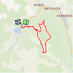
Tocht Stappen van 13,7 km beschikbaar op Nieuw-Aquitanië, Pyrénées-Atlantiques, Laruns. Deze tocht wordt voorgesteld door tracegps.
Beschrijving
Superbe boucle depuis le Lac de Bious-Artigues. Magnifiques vues sur le Pic du Midi d'Ossau. Petite escalade dans le final du Pic Lavigne. Crête aérienne après le col de Magnabaigt (roche douteuse). Panoramas disponibles sur Pyrenees360.fr.
Plaatsbepaling
Land:
France
Regio :
Nieuw-Aquitanië
Departement/Provincie :
Pyrénées-Atlantiques
Gemeente :
Laruns
Locatie:
Unknown
Vertrek:(Dec)
Vertrek:(UTM)
708441 ; 4749379 (30T) N.
Opmerkingen
Wandeltochten in de omgeving
![Tocht Stappen Laruns - Ossau : Tour des lacs d’Ayous - Photo](https://media.geolcdn.com/t/375/260/506674d0-c4fd-4a53-a5f4-01b6386a74ed.jpg&format=jpg&maxdim=2)
![Stappen Stappen](https://static1.geolcdn.com/sitytour/trail-icons/101.png)
Ossau : Tour des lacs d’Ayous
Stappen
Medium
(1)
Laruns,
Nieuw-Aquitanië,
Pyrénées-Atlantiques,
France
![](/images/other/stat-length.png)
15,5 km | 25 km-effort
4h 49min
![](https://static1.geolcdn.com/siteimages/upload/files/16400158638029165_repeat_loop_refresh_sync_direction_icon.png)
Ja
![Tocht Stappen Laruns - Tour des Lacs d'Ayous en boucle depuis Bious-Artigues - Photo](https://media.geolcdn.com/t/375/260/ext.jpg?maxdim=2&url=https%3A%2F%2Fservices.sitytrail.com%2FGeolivesWS%2FDownloadMedia.ashx%3FTrailID%3D109944%26Media%3D5004_1.jpg)
![Stappen Stappen](https://static1.geolcdn.com/sitytour/trail-icons/101.png)
Tour des Lacs d'Ayous en boucle depuis Bious-Artigues
Stappen
Medium
(4)
Laruns,
Nieuw-Aquitanië,
Pyrénées-Atlantiques,
France
![](/images/other/stat-length.png)
14,1 km | 24 km-effort
5h 30min
![](https://static1.geolcdn.com/siteimages/upload/files/16400158638029165_repeat_loop_refresh_sync_direction_icon.png)
Ja
![Tocht Stappen Laruns - Tour des Lacs d'Ayous + Pic des Moines (2349m) - Photo](https://media.geolcdn.com/t/375/260/ext.jpg?maxdim=2&url=https%3A%2F%2Fservices.sitytrail.com%2FGeolivesWS%2FDownloadMedia.ashx%3FTrailID%3D103574%26Media%3D5886_1.jpg)
![Stappen Stappen](https://static1.geolcdn.com/sitytour/trail-icons/101.png)
Tour des Lacs d'Ayous + Pic des Moines (2349m)
Stappen
Moeilijk
(1)
Laruns,
Nieuw-Aquitanië,
Pyrénées-Atlantiques,
France
![](/images/other/stat-length.png)
15 km | 27 km-effort
5h 30min
![](https://static1.geolcdn.com/siteimages/upload/files/16400158638029165_repeat_loop_refresh_sync_direction_icon.png)
Ja
![Tocht Stappen Laruns - GR 10 - U - Photo](https://media.geolcdn.com/t/375/260/ext.jpg?maxdim=2&url=https%3A%2F%2Fstatic1.geolcdn.com%2Fsiteimages%2Fupload%2Ffiles%2F1553511878bg_sport_marche.png)
![Stappen Stappen](https://static1.geolcdn.com/sitytour/trail-icons/101.png)
GR 10 - U
Stappen
Zeer moeilijk
(1)
Laruns,
Nieuw-Aquitanië,
Pyrénées-Atlantiques,
France
![](/images/other/stat-length.png)
12,9 km | 26 km-effort
5h 1min
![](https://static1.geolcdn.com/siteimages/upload/files/16400158638029165_repeat_loop_refresh_sync_direction_icon.png)
Neen
![Tocht Stappen Laruns - chemin des fenetres - Photo](https://media.geolcdn.com/t/375/260/ext.jpg?maxdim=2&url=https%3A%2F%2Fstatic1.geolcdn.com%2Fsiteimages%2Fupload%2Ffiles%2F1553511878bg_sport_marche.png)
![Stappen Stappen](https://static1.geolcdn.com/sitytour/trail-icons/101.png)
chemin des fenetres
Stappen
Gemakkelijk
(1)
Laruns,
Nieuw-Aquitanië,
Pyrénées-Atlantiques,
France
![](/images/other/stat-length.png)
8 km | 14,1 km-effort
3h 0min
![](https://static1.geolcdn.com/siteimages/upload/files/16400158638029165_repeat_loop_refresh_sync_direction_icon.png)
Neen
![Tocht sport Laruns - Gabas Etsaut - Photo](https://media.geolcdn.com/t/375/260/7c21af10-1d22-476f-b216-9aa4a04acfe4.jpg&format=jpg&maxdim=2)
Gabas Etsaut
sport
Heel gemakkelijk
Laruns,
Nieuw-Aquitanië,
Pyrénées-Atlantiques,
France
![](/images/other/stat-length.png)
26 km | 44 km-effort
Onbekend
![](https://static1.geolcdn.com/siteimages/upload/files/16400158638029165_repeat_loop_refresh_sync_direction_icon.png)
Neen
![Tocht Stappen Laruns - Lac d’Aule et Col du Turin Garié - Photo](https://media.geolcdn.com/t/375/260/5b20a947-15d2-453e-9b90-ef85d05c68e0.jpg&format=jpg&maxdim=2)
![Stappen Stappen](https://static1.geolcdn.com/sitytour/trail-icons/101.png)
Lac d’Aule et Col du Turin Garié
Stappen
Moeilijk
Laruns,
Nieuw-Aquitanië,
Pyrénées-Atlantiques,
France
![](/images/other/stat-length.png)
11,7 km | 25 km-effort
5h 37min
![](https://static1.geolcdn.com/siteimages/upload/files/16400158638029165_repeat_loop_refresh_sync_direction_icon.png)
Ja
![Tocht Stappen Laruns - lacs d'Ayous - Photo](https://media.geolcdn.com/t/375/260/dd136f74-904d-495b-bdb2-8389a76c47db.jpg&format=jpg&maxdim=2)
![Stappen Stappen](https://static1.geolcdn.com/sitytour/trail-icons/101.png)
lacs d'Ayous
Stappen
Zeer moeilijk
Laruns,
Nieuw-Aquitanië,
Pyrénées-Atlantiques,
France
![](/images/other/stat-length.png)
14,5 km | 24 km-effort
7h 33min
![](https://static1.geolcdn.com/siteimages/upload/files/16400158638029165_repeat_loop_refresh_sync_direction_icon.png)
Ja
![Tocht Te voet Laruns - Voie d'OssauB - Photo](https://media.geolcdn.com/t/375/260/7ccbfa81-52aa-450a-9353-320987110b82.jpeg&format=jpg&maxdim=2)
![Te voet Te voet](https://static1.geolcdn.com/sitytour/trail-icons/100.png)
Voie d'OssauB
Te voet
Medium
Laruns,
Nieuw-Aquitanië,
Pyrénées-Atlantiques,
France
![](/images/other/stat-length.png)
14,1 km | 24 km-effort
5h 32min
![](https://static1.geolcdn.com/siteimages/upload/files/16400158638029165_repeat_loop_refresh_sync_direction_icon.png)
Neen