![](/images/other/stat-length.png)
![Tocht Stappen Saint-Clément - Du petit Goul au grand Goul - Saint Clément - Photo](https://media.geolcdn.com/t/1900/400/ext.pjpeg?maxdim=2&url=https%3A%2F%2Fservices.sitytrail.com%2FGeolivesWS%2FDownloadMedia.ashx%3FTrailID%3D129646%26Media%3D13169_2.jpg)
Du petit Goul au grand Goul - Saint Clément
tracegps
Gebruiker
![Lengte](/images/other/stat-length.png)
![Max. hoogte](https://static1.geolcdn.com/siteimages/upload/files/1508320355ic_sort_altitude_max_24dp.png)
![Positief hoogteverschil](https://static1.geolcdn.com/siteimages/upload/files/1508320355ic_sort_den_pos_24dp.png)
![Km-Effort](/images/other/stat-length.png)
![Min. hoogte](https://static1.geolcdn.com/siteimages/upload/files/1508320355ic_sort_altitude_min_24dp.png)
![Negatief hoogteverschil](https://static1.geolcdn.com/siteimages/upload/files/1508320355ic_sort_den_neg_24dp.png)
![Boucle](https://static1.geolcdn.com/siteimages/upload/files/16400158638029165_repeat_loop_refresh_sync_direction_icon.png)
![Stappen](https://static1.geolcdn.com/sitytour/trail-icons/101.png)
3h00
Moeilijkheid : Medium
![Scan deze QR-code om de tocht te openen in de SityTrail-applicatie](https://capi.geolives.com/qq0zvz2zws4bq2lad0pu/sitytour/trails/129646/qr.png?size=200)
Gratisgps-wandelapplicatie
Over ons
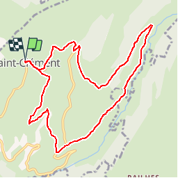
Tocht Stappen van 10,8 km beschikbaar op Auvergne-Rhône-Alpes, Cantal, Saint-Clément. Deze tocht wordt voorgesteld door tracegps.
Beschrijving
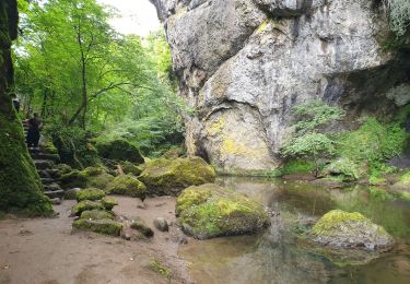
La rivière Goul prend sa source à 1400 m d'altitude environ sur la commune de Saint Clément. Terre d'estive, comme Pailherols et Badailhac, ici aussi on retrouve la tradition pastorale et les burons ou fermes d'altitude. Circuit inscrit au Plan départemental des Itinéraires de Petites Randonnées. Départ : place de l'église et de la mairie de St Clément. Chiens déconseillés, en raison des troupeaux de vaches en pâture.
Plaatsbepaling
Opmerkingen
Wandeltochten in de omgeving
![Tocht Stappen Thiézac - La Porte du Lion - Thiézac - Photo](https://media.geolcdn.com/t/375/260/ext.jpg?maxdim=2&url=https%3A%2F%2Fservices.sitytrail.com%2FGeolivesWS%2FDownloadMedia.ashx%3FTrailID%3D129644%26Media%3D13165_3.jpg)
![Stappen Stappen](https://static1.geolcdn.com/sitytour/trail-icons/101.png)
Stappen
![](/images/other/stat-length.png)
![](https://static1.geolcdn.com/siteimages/upload/files/16400158638029165_repeat_loop_refresh_sync_direction_icon.png)
![Stappen Stappen](https://static1.geolcdn.com/sitytour/trail-icons/101.png)
Stappen
![](/images/other/stat-length.png)
![](https://static1.geolcdn.com/siteimages/upload/files/16400158638029165_repeat_loop_refresh_sync_direction_icon.png)
![Tocht Stappen Thiézac - Puy de la poche - Photo](https://media.geolcdn.com/t/375/260/f3ce84a8-7fd4-461e-ae03-56b4255cfce0.jpg&format=jpg&maxdim=2)
![Stappen Stappen](https://static1.geolcdn.com/sitytour/trail-icons/101.png)
Stappen
![](/images/other/stat-length.png)
![](https://static1.geolcdn.com/siteimages/upload/files/16400158638029165_repeat_loop_refresh_sync_direction_icon.png)
![Tocht Stappen Jou-sous-Monjou - Cantal - Jou sous Monjou - 7.7km 300m 2h40 - 2019 06 27 - Photo](https://media.geolcdn.com/t/375/260/37f7eb5b-9c4b-4567-b1b4-a0d6937e405c.jpg&format=jpg&maxdim=2)
![Stappen Stappen](https://static1.geolcdn.com/sitytour/trail-icons/101.png)
Stappen
![](/images/other/stat-length.png)
![](https://static1.geolcdn.com/siteimages/upload/files/16400158638029165_repeat_loop_refresh_sync_direction_icon.png)
![Tocht Stappen Thiézac - La porte du Lion - Thiézac - Photo](https://media.geolcdn.com/t/375/260/ext.jpg?maxdim=2&url=https%3A%2F%2Fstatic1.geolcdn.com%2Fsiteimages%2Fupload%2Ffiles%2F1553511878bg_sport_marche.png)
![Stappen Stappen](https://static1.geolcdn.com/sitytour/trail-icons/101.png)
Stappen
![](/images/other/stat-length.png)
![](https://static1.geolcdn.com/siteimages/upload/files/16400158638029165_repeat_loop_refresh_sync_direction_icon.png)
![Tocht Trail Vic-sur-Cère - Cascade, la Garde, grotte des anglais - Photo](https://media.geolcdn.com/t/375/260/2f654d5e-2308-4101-8214-c057fbfbda64.jpg&format=jpg&maxdim=2)
![Trail Trail](https://static1.geolcdn.com/sitytour/trail-icons/104.png)
Trail
![](/images/other/stat-length.png)
![](https://static1.geolcdn.com/siteimages/upload/files/16400158638029165_repeat_loop_refresh_sync_direction_icon.png)
![Tocht Stappen Pailherols - Pailherols chapelle du Cantal - Photo](https://media.geolcdn.com/t/375/260/72f007a6-9633-43a2-aa21-fbef48e3a249.jpg&format=jpg&maxdim=2)
![Stappen Stappen](https://static1.geolcdn.com/sitytour/trail-icons/101.png)
Stappen
![](/images/other/stat-length.png)
![](https://static1.geolcdn.com/siteimages/upload/files/16400158638029165_repeat_loop_refresh_sync_direction_icon.png)
![Tocht Stappen Vic-sur-Cère - Pas de Cère- cascade de Gourdole - Photo](https://media.geolcdn.com/t/375/260/88d7000e-837e-4895-ace1-8d40f2abe4ca.jpg&format=jpg&maxdim=2)
![Stappen Stappen](https://static1.geolcdn.com/sitytour/trail-icons/101.png)
Stappen
![](/images/other/stat-length.png)
![](https://static1.geolcdn.com/siteimages/upload/files/16400158638029165_repeat_loop_refresh_sync_direction_icon.png)
![Tocht Stappen Thiézac - Les Gorges du Pas de Cère - Photo](https://media.geolcdn.com/t/375/260/fa38157b-57d6-4ad3-89fe-dcb1d3174ee5.jpg&format=jpg&maxdim=2)
![Stappen Stappen](https://static1.geolcdn.com/sitytour/trail-icons/101.png)
Stappen
![](/images/other/stat-length.png)
![](https://static1.geolcdn.com/siteimages/upload/files/16400158638029165_repeat_loop_refresh_sync_direction_icon.png)
Belle balade avec le soleil et la neige et de jolis chemins