![](/images/other/stat-length.png)
![Tocht Stappen Savonnières - Savonnières - Photo](https://media.geolcdn.com/t/1900/400/ext.pjpeg?maxdim=2&url=https%3A%2F%2Fstatic1.geolcdn.com%2Fsiteimages%2Fupload%2Ffiles%2F1553511878bg_sport_marche.png)
Savonnières
LEMENIO
Gebruiker
![Lengte](/images/other/stat-length.png)
Lengte
11,8 km
![Max. hoogte](https://static1.geolcdn.com/siteimages/upload/files/1508320355ic_sort_altitude_max_24dp.png)
Max. hoogte
89 m
![Positief hoogteverschil](https://static1.geolcdn.com/siteimages/upload/files/1508320355ic_sort_den_pos_24dp.png)
Positief hoogteverschil
135 m
![Km-Effort](/images/other/stat-length.png)
Km-Effort
13,6 km
![Min. hoogte](https://static1.geolcdn.com/siteimages/upload/files/1508320355ic_sort_altitude_min_24dp.png)
Min. hoogte
40 m
![Negatief hoogteverschil](https://static1.geolcdn.com/siteimages/upload/files/1508320355ic_sort_den_neg_24dp.png)
Negatief hoogteverschil
134 m
![Boucle](https://static1.geolcdn.com/siteimages/upload/files/16400158638029165_repeat_loop_refresh_sync_direction_icon.png)
Boucle
Ja
Datum van aanmaak :
2014-12-10 00:00:00.0
Laatste wijziging :
2014-12-10 00:00:00.0
![Stappen](https://static1.geolcdn.com/sitytour/trail-icons/101.png)
3h00
Moeilijkheid : Medium
![Scan deze QR-code om de tocht te openen in de SityTrail-applicatie](https://capi.geolives.com/qq0zvz2zws4bq2lad0pu/sitytour/trails/120998/qr.png?size=200)
Gratisgps-wandelapplicatie
Over ons
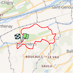
Tocht Stappen van 11,8 km beschikbaar op Centre-Val de Loire, Indre-et-Loire, Savonnières. Deze tocht wordt voorgesteld door LEMENIO.
Beschrijving
Départ place des charmilles. La fin de parcours peut être raccourcie de 2.5 Km en filant tout droit jusqu'au bas de la rue du paradis ( entrée du bourg). Sinon tourner à gauche pour faire la boucle finale (fin de descente un peu raide).
Plaatsbepaling
Land:
France
Regio :
Centre-Val de Loire
Departement/Provincie :
Indre-et-Loire
Gemeente :
Savonnières
Locatie:
Unknown
Vertrek:(Dec)
Vertrek:(UTM)
314747 ; 5246792 (31T) N.
Opmerkingen
Wandeltochten in de omgeving
![Stappen Stappen](https://static1.geolcdn.com/sitytour/trail-icons/101.png)
Villandry - 2015 05 24
Stappen
Gemakkelijk
(1)
Villandry,
Centre-Val de Loire,
Indre-et-Loire,
France
![](/images/other/stat-length.png)
4,9 km | 5,7 km-effort
1h 15min
![](https://static1.geolcdn.com/siteimages/upload/files/16400158638029165_repeat_loop_refresh_sync_direction_icon.png)
Ja
![Tocht Stappen Fondettes - Fondettes Vallières - Luynes Le Vieux-Bourg - 26.1km 360m 5h30 (45mn) - 2024 12 11 - Photo](https://media.geolcdn.com/t/375/260/7ea9ad8d-3a09-4814-97d4-258e1355629e.jpg&format=jpg&maxdim=2)
![Stappen Stappen](https://static1.geolcdn.com/sitytour/trail-icons/101.png)
Fondettes Vallières - Luynes Le Vieux-Bourg - 26.1km 360m 5h30 (45mn) - 2024 ...
Stappen
Medium
Fondettes,
Centre-Val de Loire,
Indre-et-Loire,
France
![](/images/other/stat-length.png)
26 km | 31 km-effort
5h 30min
![](https://static1.geolcdn.com/siteimages/upload/files/16400158638029165_repeat_loop_refresh_sync_direction_icon.png)
Ja
![Tocht Stappen Savonnières - Savonnières - Zig zag Villandry - 20.7km 260m 4h25 (40mn) - 2024 06 02 - Photo](https://media.geolcdn.com/t/375/260/12f64fcc-4f3e-4220-83eb-fe5365015280.jpg&format=jpg&maxdim=2)
![Stappen Stappen](https://static1.geolcdn.com/sitytour/trail-icons/101.png)
Savonnières - Zig zag Villandry - 20.7km 260m 4h25 (40mn) - 2024 06 02
Stappen
Gemakkelijk
Savonnières,
Centre-Val de Loire,
Indre-et-Loire,
France
![](/images/other/stat-length.png)
21 km | 24 km-effort
4h 25min
![](https://static1.geolcdn.com/siteimages/upload/files/16400158638029165_repeat_loop_refresh_sync_direction_icon.png)
Ja
![Tocht Stappen Ballan-Miré - Ballan-Miré - Parking des Châtaigniers - 8.4km 125m 1h50 - 2024 03 06 - Photo](https://media.geolcdn.com/t/375/260/1a378f68-cb26-4349-9743-c95ed818731a.jpg&format=jpg&maxdim=2)
![Stappen Stappen](https://static1.geolcdn.com/sitytour/trail-icons/101.png)
Ballan-Miré - Parking des Châtaigniers - 8.4km 125m 1h50 - 2024 03 06
Stappen
Medium
Ballan-Miré,
Centre-Val de Loire,
Indre-et-Loire,
France
![](/images/other/stat-length.png)
8,4 km | 10,1 km-effort
1h 50min
![](https://static1.geolcdn.com/siteimages/upload/files/16400158638029165_repeat_loop_refresh_sync_direction_icon.png)
Ja
![Tocht Stappen Saint-Étienne-de-Chigny - Saint-Étienne-de-Chigny - le Vieux Bourg - Luynes - 15.8km 285m 3h30 - 2024 02 28 - Photo](https://media.geolcdn.com/t/375/260/b6ad8ad7-2214-4d55-9cd7-2ee78c3b27ee.jpg&format=jpg&maxdim=2)
![Stappen Stappen](https://static1.geolcdn.com/sitytour/trail-icons/101.png)
Saint-Étienne-de-Chigny - le Vieux Bourg - Luynes - 15.8km 285m 3h30 - 2024 0...
Stappen
Medium
Saint-Étienne-de-Chigny,
Centre-Val de Loire,
Indre-et-Loire,
France
![](/images/other/stat-length.png)
15,8 km | 19,6 km-effort
3h 30min
![](https://static1.geolcdn.com/siteimages/upload/files/16400158638029165_repeat_loop_refresh_sync_direction_icon.png)
Ja
![Tocht Stappen Saint-Étienne-de-Chigny - Saint-Étienne-de-Chigny - la Pile de Cinq-Mars-la-Pile - 14.2km 215m 3h15 - 2024 02 17 - Photo](https://media.geolcdn.com/t/375/260/84d699f2-9fbc-4977-9839-f8db73d27f73.jpg&format=jpg&maxdim=2)
![Stappen Stappen](https://static1.geolcdn.com/sitytour/trail-icons/101.png)
Saint-Étienne-de-Chigny - la Pile de Cinq-Mars-la-Pile - 14.2km 215m 3h15 - 2...
Stappen
Medium
Saint-Étienne-de-Chigny,
Centre-Val de Loire,
Indre-et-Loire,
France
![](/images/other/stat-length.png)
14,5 km | 17,2 km-effort
3h 15min
![](https://static1.geolcdn.com/siteimages/upload/files/16400158638029165_repeat_loop_refresh_sync_direction_icon.png)
Ja
![Tocht Stappen Savonnières - Savonnières - les Fontaines GR3 et PRs - 20.1km 190m 4h40 - 2022 05 12 - Photo](https://media.geolcdn.com/t/375/260/58a53b1f-8878-4695-8af8-d5fb36baa215.jpg&format=jpg&maxdim=2)
![Stappen Stappen](https://static1.geolcdn.com/sitytour/trail-icons/101.png)
Savonnières - les Fontaines GR3 et PRs - 20.1km 190m 4h40 - 2022 05 12
Stappen
Gemakkelijk
Savonnières,
Centre-Val de Loire,
Indre-et-Loire,
France
![](/images/other/stat-length.png)
20 km | 23 km-effort
4h 40min
![](https://static1.geolcdn.com/siteimages/upload/files/16400158638029165_repeat_loop_refresh_sync_direction_icon.png)
Ja
![Tocht Stappen Berthenay - Berthenay - Sentier des deux Eaux - 16.3km 65m 4h00 - 2022 05 08 - Photo](https://media.geolcdn.com/t/375/260/0ed1278a-60ca-4774-800b-77548f464139.jpg&format=jpg&maxdim=2)
![Stappen Stappen](https://static1.geolcdn.com/sitytour/trail-icons/101.png)
Berthenay - Sentier des deux Eaux - 16.3km 65m 4h00 - 2022 05 08
Stappen
Gemakkelijk
Berthenay,
Centre-Val de Loire,
Indre-et-Loire,
France
![](/images/other/stat-length.png)
16,3 km | 17,2 km-effort
4h 0min
![](https://static1.geolcdn.com/siteimages/upload/files/16400158638029165_repeat_loop_refresh_sync_direction_icon.png)
Ja
![Tocht Stappen Saint-Étienne-de-Chigny - Saint-Étienne-de-Chigny - Pont de Bresme - 23.4km 275m 4h45 (25mn) - 2021 07 08 - Photo](https://media.geolcdn.com/t/375/260/99af599b-914a-4e89-a7d1-8d362555a6d7.jpg&format=jpg&maxdim=2)
![Stappen Stappen](https://static1.geolcdn.com/sitytour/trail-icons/101.png)
Saint-Étienne-de-Chigny - Pont de Bresme - 23.4km 275m 4h45 (25mn) - 2021 07 08
Stappen
Gemakkelijk
Saint-Étienne-de-Chigny,
Centre-Val de Loire,
Indre-et-Loire,
France
![](/images/other/stat-length.png)
23 km | 27 km-effort
4h 45min
![](https://static1.geolcdn.com/siteimages/upload/files/16400158638029165_repeat_loop_refresh_sync_direction_icon.png)
Ja