![](/images/other/stat-length.png)
![Tocht Fietstoerisme Hasparren - B - Hasparren - La vallée de l'Adour - Photo](https://media.geolcdn.com/t/1900/400/ext.pjpeg?maxdim=2&url=https%3A%2F%2Fstatic1.geolcdn.com%2Fsiteimages%2Fupload%2Ffiles%2F1524743154velo.jpg)
B - Hasparren - La vallée de l'Adour
potofe
Gebruiker
![Lengte](/images/other/stat-length.png)
Lengte
88 km
![Max. hoogte](https://static1.geolcdn.com/siteimages/upload/files/1508320355ic_sort_altitude_max_24dp.png)
Max. hoogte
186 m
![Positief hoogteverschil](https://static1.geolcdn.com/siteimages/upload/files/1508320355ic_sort_den_pos_24dp.png)
Positief hoogteverschil
1491 m
![Km-Effort](/images/other/stat-length.png)
Km-Effort
108 km
![Min. hoogte](https://static1.geolcdn.com/siteimages/upload/files/1508320355ic_sort_altitude_min_24dp.png)
Min. hoogte
-5 m
![Negatief hoogteverschil](https://static1.geolcdn.com/siteimages/upload/files/1508320355ic_sort_den_neg_24dp.png)
Negatief hoogteverschil
1499 m
![Boucle](https://static1.geolcdn.com/siteimages/upload/files/16400158638029165_repeat_loop_refresh_sync_direction_icon.png)
Boucle
Ja
Datum van aanmaak :
2018-09-07 19:25:02.247
Laatste wijziging :
2024-08-15 15:05:13.656
![Fietstoerisme](https://static1.geolcdn.com/sitytour/trail-icons/204.png)
--
Moeilijkheid : Zeer moeilijk
![Scan deze QR-code om de tocht te openen in de SityTrail-applicatie](https://capi.geolives.com/qq0zvz2zws4bq2lad0pu/sitytour/trails/119973/qr.png?size=200)
Gratisgps-wandelapplicatie
Over ons
Tocht Fietstoerisme van 88 km beschikbaar op Nieuw-Aquitanië, Pyrénées-Atlantiques, Hasparren. Deze tocht wordt voorgesteld door potofe.
Beschrijving
Vélo 64
Rando N°7
Parcours ½ journée ou journée, vallonné, pour cyclotouriste moyen (entrainement de 2 à 3000 km). Petirs braquets recommandés (28x24 ou 28x26 par exemple).
Plaatsbepaling
Land:
France
Regio :
Nieuw-Aquitanië
Departement/Provincie :
Pyrénées-Atlantiques
Gemeente :
Hasparren
Locatie:
Unknown
Vertrek:(Dec)
Vertrek:(UTM)
637260 ; 4804895 (30T) N.
Opmerkingen
Wandeltochten in de omgeving
![Tocht Stappen Hasparren - Ursuya - Photo](https://media.geolcdn.com/t/375/260/5b6594c9-7464-40b5-ab4d-e519503b5914.jpg&format=jpg&maxdim=2)
![Stappen Stappen](https://static1.geolcdn.com/sitytour/trail-icons/101.png)
Ursuya
Stappen
Medium
(1)
Hasparren,
Nieuw-Aquitanië,
Pyrénées-Atlantiques,
France
![](/images/other/stat-length.png)
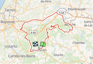
10,8 km | 18,5 km-effort
3h 40min
![](https://static1.geolcdn.com/siteimages/upload/files/16400158638029165_repeat_loop_refresh_sync_direction_icon.png)
Ja
![Tocht Stappen Hasparren - Haitzeder boucle - Photo](https://media.geolcdn.com/t/375/260/68f2128d-058b-4818-b520-cd2bd848b62c.jpg&format=jpg&maxdim=2)
![Stappen Stappen](https://static1.geolcdn.com/sitytour/trail-icons/101.png)
Haitzeder boucle
Stappen
Gemakkelijk
(1)
Hasparren,
Nieuw-Aquitanië,
Pyrénées-Atlantiques,
France
![](/images/other/stat-length.png)
8,3 km | 11,7 km-effort
2h 28min
![](https://static1.geolcdn.com/siteimages/upload/files/16400158638029165_repeat_loop_refresh_sync_direction_icon.png)
Ja
![Tocht Andere activiteiten La Bastide-Clairence - Pierroun - Photo](https://media.geolcdn.com/t/375/260/ext.jpg?maxdim=2&url=https%3A%2F%2Fstatic1.geolcdn.com%2Fsiteimages%2Fupload%2Ffiles%2F1545311037marcheuse_200dpi.jpg)
![Andere activiteiten Andere activiteiten](https://static1.geolcdn.com/sitytour/trail-icons/900.png)
Pierroun
Andere activiteiten
Heel gemakkelijk
(1)
La Bastide-Clairence,
Nieuw-Aquitanië,
Pyrénées-Atlantiques,
France
![](/images/other/stat-length.png)
8,2 km | 11,3 km-effort
2h 0min
![](https://static1.geolcdn.com/siteimages/upload/files/16400158638029165_repeat_loop_refresh_sync_direction_icon.png)
Ja
![Tocht Stappen Hasparren - ursuya - Photo](https://media.geolcdn.com/t/375/260/ext.jpg?maxdim=2&url=https%3A%2F%2Fstatic1.geolcdn.com%2Fsiteimages%2Fupload%2Ffiles%2F1553511878bg_sport_marche.png)
![Stappen Stappen](https://static1.geolcdn.com/sitytour/trail-icons/101.png)
ursuya
Stappen
Heel gemakkelijk
(2)
Hasparren,
Nieuw-Aquitanië,
Pyrénées-Atlantiques,
France
![](/images/other/stat-length.png)
13,6 km | 22 km-effort
3h 8min
![](https://static1.geolcdn.com/siteimages/upload/files/16400158638029165_repeat_loop_refresh_sync_direction_icon.png)
Ja
![Tocht Stappen Hasparren - landes hasparren - Photo](https://media.geolcdn.com/t/375/260/9976acab-22ed-4393-bb84-453bc9aa326f.jpg&format=jpg&maxdim=2)
![Stappen Stappen](https://static1.geolcdn.com/sitytour/trail-icons/101.png)
landes hasparren
Stappen
Heel gemakkelijk
Hasparren,
Nieuw-Aquitanië,
Pyrénées-Atlantiques,
France
![](/images/other/stat-length.png)
10,2 km | 13,5 km-effort
2h 44min
![](https://static1.geolcdn.com/siteimages/upload/files/16400158638029165_repeat_loop_refresh_sync_direction_icon.png)
Ja
![Tocht Stappen Hasparren - Boucle Pilota Plaza Hasparren Briscous - Photo](https://media.geolcdn.com/t/375/260/85b26044-56fb-4088-90ae-04fdafe6b05a.jpg&format=jpg&maxdim=2)
![Stappen Stappen](https://static1.geolcdn.com/sitytour/trail-icons/101.png)
Boucle Pilota Plaza Hasparren Briscous
Stappen
Heel gemakkelijk
Hasparren,
Nieuw-Aquitanië,
Pyrénées-Atlantiques,
France
![](/images/other/stat-length.png)
11,2 km | 14,3 km-effort
2h 42min
![](https://static1.geolcdn.com/siteimages/upload/files/16400158638029165_repeat_loop_refresh_sync_direction_icon.png)
Ja
![Tocht Te voet Hasparren - Hasparren laberi Ense - Photo](https://media.geolcdn.com/t/375/260/08a50a95-869a-4e46-aa45-84c6b2cc454e.jpg&format=jpg&maxdim=2)
![Te voet Te voet](https://static1.geolcdn.com/sitytour/trail-icons/100.png)
Hasparren laberi Ense
Te voet
Gemakkelijk
Hasparren,
Nieuw-Aquitanië,
Pyrénées-Atlantiques,
France
![](/images/other/stat-length.png)
10,5 km | 13,8 km-effort
3h 7min
![](https://static1.geolcdn.com/siteimages/upload/files/16400158638029165_repeat_loop_refresh_sync_direction_icon.png)
Ja
![Tocht Stappen Hasparren - Ursuya Boucle - Photo](https://media.geolcdn.com/t/375/260/f9ba8e38-c272-4139-a3f1-4a05e11979b9.jpg&format=jpg&maxdim=2)
![Stappen Stappen](https://static1.geolcdn.com/sitytour/trail-icons/101.png)
Ursuya Boucle
Stappen
Gemakkelijk
Hasparren,
Nieuw-Aquitanië,
Pyrénées-Atlantiques,
France
![](/images/other/stat-length.png)
11,1 km | 18,8 km-effort
4h 25min
![](https://static1.geolcdn.com/siteimages/upload/files/16400158638029165_repeat_loop_refresh_sync_direction_icon.png)
Ja
![Tocht Stappen Hasparren - Hasparren Sentier sculpture - Photo](https://media.geolcdn.com/t/375/260/774bd062-6a2b-4d8c-a473-6b97333b479a.jpg&format=jpg&maxdim=2)
![Stappen Stappen](https://static1.geolcdn.com/sitytour/trail-icons/101.png)
Hasparren Sentier sculpture
Stappen
Gemakkelijk
(1)
Hasparren,
Nieuw-Aquitanië,
Pyrénées-Atlantiques,
France
![](/images/other/stat-length.png)
7,2 km | 9,1 km-effort
2h 14min
![](https://static1.geolcdn.com/siteimages/upload/files/16400158638029165_repeat_loop_refresh_sync_direction_icon.png)
Ja
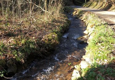
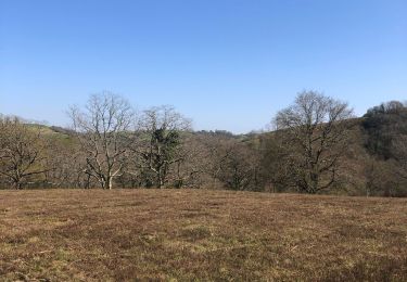
Joli parcours, exigeant. La longue ligne droite après être passé sous l'autoroute, permet d'utiliser un peu le grand plateau et de respirer un peu. Cela équilibre cette belle sortieMerci de l'avoir partagée