![](/images/other/stat-length.png)
![Tocht Stappen Serres - Autour du Pech Cardou - De Serres à Rennes-les-Bains - Photo](https://media.geolcdn.com/t/1900/400/ext.pjpeg?maxdim=2&url=https%3A%2F%2Fservices.sitytrail.com%2FGeolivesWS%2FDownloadMedia.ashx%3FTrailID%3D118845%26Media%3D13060_6.jpg)
Autour du Pech Cardou - De Serres à Rennes-les-Bains
tracegps
Gebruiker
![Lengte](/images/other/stat-length.png)
![Max. hoogte](https://static1.geolcdn.com/siteimages/upload/files/1508320355ic_sort_altitude_max_24dp.png)
![Positief hoogteverschil](https://static1.geolcdn.com/siteimages/upload/files/1508320355ic_sort_den_pos_24dp.png)
![Km-Effort](/images/other/stat-length.png)
![Min. hoogte](https://static1.geolcdn.com/siteimages/upload/files/1508320355ic_sort_altitude_min_24dp.png)
![Negatief hoogteverschil](https://static1.geolcdn.com/siteimages/upload/files/1508320355ic_sort_den_neg_24dp.png)
![Boucle](https://static1.geolcdn.com/siteimages/upload/files/16400158638029165_repeat_loop_refresh_sync_direction_icon.png)
![Stappen](https://static1.geolcdn.com/sitytour/trail-icons/101.png)
5h30
Moeilijkheid : Medium
![Scan deze QR-code om de tocht te openen in de SityTrail-applicatie](https://capi.geolives.com/qq0zvz2zws4bq2lad0pu/sitytour/trails/118845/qr.png?size=200)
Gratisgps-wandelapplicatie
Over ons
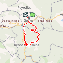
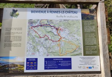
Tocht Stappen van 14,5 km beschikbaar op Occitanië, Aude, Serres. Deze tocht wordt voorgesteld door tracegps.
Beschrijving
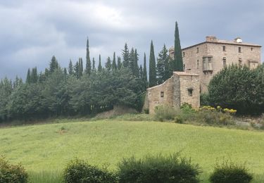
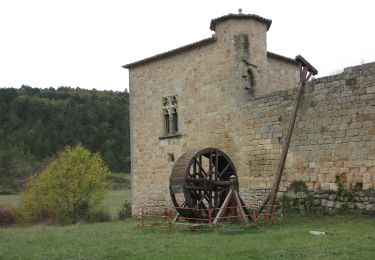
Cette sortie est organisée par Pierre. De Carcassonne prendre direction Limoux puis à Couiza tourner à gauche jusqu'à Serres. Avec presque 600m de dénivelé et 5h30 de marche, cette randonnée de 14.5 km est plutôt facile. Départ du village de Serres et montée directe au sommet du Pech Cardou puis descente en pente douce sur Montferrand par un chemin. On emprunte ensuite une petite route qui nous amène à Rennes-les-Bains. De là on rejoint Serres par un sentier agréable. On pousse jusqu'au château puis retour au parking.
Plaatsbepaling
Opmerkingen
Wandeltochten in de omgeving
![Tocht Fiets Arques - CCS FFC Aude en Pyrénées - Circuit n°11 - Arques - Photo](https://media.geolcdn.com/t/375/260/ext.jpg?maxdim=2&url=https%3A%2F%2Fservices.sitytrail.com%2FGeolivesWS%2FDownloadMedia.ashx%3FTrailID%3D111470%26Media%3D7353_1.jpg)
![Fiets Fiets](https://static1.geolcdn.com/sitytour/trail-icons/200.png)
Fiets
![](/images/other/stat-length.png)
![](https://static1.geolcdn.com/siteimages/upload/files/16400158638029165_repeat_loop_refresh_sync_direction_icon.png)
![Tocht Stappen Serres - Serres Cardou - Photo](https://media.geolcdn.com/t/375/260/3dcdcfad-e675-4328-969d-93b02c6e2d21.jpg&format=jpg&maxdim=2)
![Stappen Stappen](https://static1.geolcdn.com/sitytour/trail-icons/101.png)
![Tocht Te voet Arques - La Frau - Photo](https://media.geolcdn.com/t/375/260/dd7678c6-a794-444d-a52c-e2d60c9d9291.jpeg&format=jpg&maxdim=2)
![Te voet Te voet](https://static1.geolcdn.com/sitytour/trail-icons/100.png)
![Tocht Te voet Arques - Les Berques - Photo](https://media.geolcdn.com/t/375/260/84344748-6b6d-47a0-bbe7-d97839fec542.jpeg&format=jpg&maxdim=2)
![Te voet Te voet](https://static1.geolcdn.com/sitytour/trail-icons/100.png)
Te voet
![](/images/other/stat-length.png)
![](https://static1.geolcdn.com/siteimages/upload/files/16400158638029165_repeat_loop_refresh_sync_direction_icon.png)
![Tocht Stappen Arques - Arques 29 09 3019 - Photo](https://media.geolcdn.com/t/375/260/d8261a14-6ebe-438a-a45c-071567d1fc57.jpg&format=jpg&maxdim=2)
![Stappen Stappen](https://static1.geolcdn.com/sitytour/trail-icons/101.png)
Stappen
![](/images/other/stat-length.png)
![](https://static1.geolcdn.com/siteimages/upload/files/16400158638029165_repeat_loop_refresh_sync_direction_icon.png)
![Tocht Stappen Rennes-les-Bains - Sources Rennes les bains - Photo](https://media.geolcdn.com/t/375/260/ext.jpg?maxdim=2&url=https%3A%2F%2Fservices.sitytrail.com%2FGeolivesWS%2FDownloadMedia.ashx%3FTrailID%3D139042%26Media%3D20120625205934.jpeg)
![Stappen Stappen](https://static1.geolcdn.com/sitytour/trail-icons/101.png)
Stappen
![](/images/other/stat-length.png)
![](https://static1.geolcdn.com/siteimages/upload/files/16400158638029165_repeat_loop_refresh_sync_direction_icon.png)
![Tocht Stappen Rennes-le-Château - Rennes le Château - Photo](https://media.geolcdn.com/t/375/260/1a7a8025-e376-4adf-91ac-565091fd51c9.jpg&format=jpg&maxdim=2)
![Stappen Stappen](https://static1.geolcdn.com/sitytour/trail-icons/101.png)
Stappen
![](/images/other/stat-length.png)
![](https://static1.geolcdn.com/siteimages/upload/files/16400158638029165_repeat_loop_refresh_sync_direction_icon.png)
![Tocht Stappen Rennes-les-Bains - Rennes-les-Bains-le fauteuil du diable - Photo](https://media.geolcdn.com/t/375/260/00addcaa-31da-40b2-8ced-3828d5d82226.jpg&format=jpg&maxdim=2)
![Stappen Stappen](https://static1.geolcdn.com/sitytour/trail-icons/101.png)
Stappen
![](/images/other/stat-length.png)
![](https://static1.geolcdn.com/siteimages/upload/files/16400158638029165_repeat_loop_refresh_sync_direction_icon.png)
![Tocht Stappen Rennes-les-Bains - Rennes-les-Bains le pech Cardou - Photo](https://media.geolcdn.com/t/375/260/15aaa3e2-afa0-4a81-ba73-18c11f064f8c.jpg&format=jpg&maxdim=2)
![Stappen Stappen](https://static1.geolcdn.com/sitytour/trail-icons/101.png)
Stappen
![](/images/other/stat-length.png)
![](https://static1.geolcdn.com/siteimages/upload/files/16400158638029165_repeat_loop_refresh_sync_direction_icon.png)