
Balade à Saint Ybars

tracegps
Gebruiker

Lengte
13,1 km

Max. hoogte
332 m

Positief hoogteverschil
272 m

Km-Effort
16,7 km

Min. hoogte
219 m

Negatief hoogteverschil
273 m
Boucle
Ja
Datum van aanmaak :
2014-12-10 00:00:00.0
Laatste wijziging :
2014-12-10 00:00:00.0
4h00
Moeilijkheid : Medium

Gratisgps-wandelapplicatie
Over ons
Tocht Stappen van 13,1 km beschikbaar op Occitanië, Ariège, Saint-Ybars. Deze tocht wordt voorgesteld door tracegps.
Beschrijving
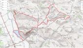
Départ du lac de St Ybars. Circuit vallonné mais empruntant une grande partie de petites routes, donc restez vigilants et visionnez le circuit avec Google Géoportail à disposition sur le site.
Plaatsbepaling
Land:
France
Regio :
Occitanië
Departement/Provincie :
Ariège
Gemeente :
Saint-Ybars
Locatie:
Unknown
Vertrek:(Dec)
Vertrek:(UTM)
368731 ; 4788069 (31T) N.
Opmerkingen
Wandeltochten in de omgeving

Villeneuve du latou fait


Stappen
Gemakkelijk
Villeneuve-du-Latou,
Occitanië,
Ariège,
France

10,1 km | 14,3 km-effort
3h 4min
Ja

Boucle du Terrefort - Sainte-Suzanne - Artigat


Paard
Medium
Sainte-Suzanne,
Occitanië,
Ariège,
France

14,6 km | 18,5 km-effort
1h 30min
Neen

Lézat sur Lèze - Saint Ybard


Paard
Medium
Lézat-sur-Lèze,
Occitanië,
Ariège,
France

9,1 km | 11,9 km-effort
1h 0min
Neen

Lézat sans boue fait 2022


Stappen
Medium
Lézat-sur-Lèze,
Occitanië,
Ariège,
France

10,7 km | 13,7 km-effort
2h 28min
Ja

6487049-Boucle de Louise (18.08.16)


Te voet
Gemakkelijk
Gaillac-Toulza,
Occitanië,
Haute-Garonne,
France

9,4 km | 12,1 km-effort
2h 10min
Ja

Moulins Lézat


Stappen
Gemakkelijk
Lézat-sur-Lèze,
Occitanië,
Ariège,
France

8,8 km | 10,7 km-effort
1h 57min
Ja

Gaillac Toulza:boucle de Louise


Stappen
Gemakkelijk
Gaillac-Toulza,
Occitanië,
Haute-Garonne,
France

9,4 km | 12,1 km-effort
2h 37min
Ja

Montgazin


Stappen
Gemakkelijk
Lézat-sur-Lèze,
Occitanië,
Ariège,
France

15,4 km | 18,7 km-effort
4h 1min
Ja

Château de PIS


Stappen
Heel gemakkelijk
Lézat-sur-Lèze,
Occitanië,
Ariège,
France

12,3 km | 14,3 km-effort
2h 30min
Ja


 SityTrail


