![](/images/other/stat-length.png)
![Tocht Motor Giverny - Giverny , les Coteaux avril 2019 - Photo](https://media.geolcdn.com/t/1900/400/ext.pjpeg?maxdim=2&url=https%3A%2F%2Fservices.sitytrail.com%2FGeolivesWS%2FDownloadMedia.ashx%3FTrailID%3D1143131%26Media%3Dfix__20190408160534.jpg)
Giverny , les Coteaux avril 2019
MichelRando7656
Gebruiker
![Lengte](/images/other/stat-length.png)
Lengte
13,6 km
![Max. hoogte](https://static1.geolcdn.com/siteimages/upload/files/1508320355ic_sort_altitude_max_24dp.png)
Max. hoogte
144 m
![Positief hoogteverschil](https://static1.geolcdn.com/siteimages/upload/files/1508320355ic_sort_den_pos_24dp.png)
Positief hoogteverschil
218 m
![Km-Effort](/images/other/stat-length.png)
Km-Effort
16,5 km
![Min. hoogte](https://static1.geolcdn.com/siteimages/upload/files/1508320355ic_sort_altitude_min_24dp.png)
Min. hoogte
15 m
![Negatief hoogteverschil](https://static1.geolcdn.com/siteimages/upload/files/1508320355ic_sort_den_neg_24dp.png)
Negatief hoogteverschil
209 m
![Boucle](https://static1.geolcdn.com/siteimages/upload/files/16400158638029165_repeat_loop_refresh_sync_direction_icon.png)
Boucle
Neen
Datum van aanmaak :
2019-04-29 10:39:11.652
Laatste wijziging :
2019-04-29 10:39:11.924
![Motor](https://static1.geolcdn.com/sitytour/trail-icons/400.png)
3h28
Moeilijkheid : Medium
![Scan deze QR-code om de tocht te openen in de SityTrail-applicatie](https://capi.geolives.com/qq0zvz2zws4bq2lad0pu/sitytour/trails/1143131/qr.png?size=200)
Gratisgps-wandelapplicatie
Over ons
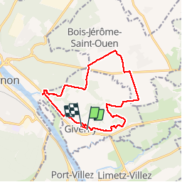
Tocht Motor van 13,6 km beschikbaar op Normandië, Eure, Giverny. Deze tocht wordt voorgesteld door MichelRando7656.
Beschrijving
Superbes panoramas. Sentiers en surplomb. Belle vue sur la campagne du plateau. Complète la visite du musée. Descentes pouvant être glissantes
Belles cotes au début et à la fin de la randonnée. Prévoir des bâtons de randonnée.
Plaatsbepaling
Land:
France
Regio :
Normandië
Departement/Provincie :
Eure
Gemeente :
Giverny
Locatie:
Unknown
Vertrek:(Dec)
Vertrek:(UTM)
392667 ; 5436925 (31U) N.
Opmerkingen
Wandeltochten in de omgeving
![Tocht Stappen Vernon - Les falaises de Seine de Vernon à Mantes la Jolie - Photo](https://media.geolcdn.com/t/375/260/5fb6d91d-220e-4b46-8986-f386f1d9411e.jpg&format=jpg&maxdim=2)
![Stappen Stappen](https://static1.geolcdn.com/sitytour/trail-icons/101.png)
Les falaises de Seine de Vernon à Mantes la Jolie
Stappen
Moeilijk
Vernon,
Normandië,
Eure,
France
![](/images/other/stat-length.png)
37 km | 47 km-effort
7h 38min
![](https://static1.geolcdn.com/siteimages/upload/files/16400158638029165_repeat_loop_refresh_sync_direction_icon.png)
Neen
![Tocht Stappen Giverny - 076-104-Giverny Matin 12km-526-030- - Photo](https://media.geolcdn.com/t/375/260/2efe6bca-4705-4852-8c25-252c9af261ae.jpg&format=jpg&maxdim=2)
![Stappen Stappen](https://static1.geolcdn.com/sitytour/trail-icons/101.png)
076-104-Giverny Matin 12km-526-030-
Stappen
Gemakkelijk
(2)
Giverny,
Normandië,
Eure,
France
![](/images/other/stat-length.png)
9,2 km | 11,5 km-effort
2h 32min
![](https://static1.geolcdn.com/siteimages/upload/files/16400158638029165_repeat_loop_refresh_sync_direction_icon.png)
Ja
![Tocht Stappen Giverny - Giverny Le lézard vert - Photo](https://media.geolcdn.com/t/375/260/b5c62cc3-3474-47fb-9b85-16cd33879457.jpg&format=jpg&maxdim=2)
![Stappen Stappen](https://static1.geolcdn.com/sitytour/trail-icons/101.png)
Giverny Le lézard vert
Stappen
Moeilijk
Giverny,
Normandië,
Eure,
France
![](/images/other/stat-length.png)
5,7 km | 7,5 km-effort
1h 57min
![](https://static1.geolcdn.com/siteimages/upload/files/16400158638029165_repeat_loop_refresh_sync_direction_icon.png)
Neen
![Tocht Stappen Giverny - Giverny : les coteaux vers le Vexin 13 km - Photo](https://media.geolcdn.com/t/375/260/c82fb9e5-5a3f-476d-97d5-3fb681dd4a31.jpg&format=jpg&maxdim=2)
![Stappen Stappen](https://static1.geolcdn.com/sitytour/trail-icons/101.png)
Giverny : les coteaux vers le Vexin 13 km
Stappen
Heel gemakkelijk
Giverny,
Normandië,
Eure,
France
![](/images/other/stat-length.png)
14,7 km | 17,8 km-effort
4h 51min
![](https://static1.geolcdn.com/siteimages/upload/files/16400158638029165_repeat_loop_refresh_sync_direction_icon.png)
Neen
![Tocht Motor Giverny - Giverny , les Coteaux avril 2019 - Photo](https://media.geolcdn.com/t/375/260/ext.jpg?maxdim=2&url=https%3A%2F%2Fservices.sitytrail.com%2FGeolivesWS%2FDownloadMedia.ashx%3FTrailID%3D1134663%26Media%3Dfix__20190408160534.jpg)
![Motor Motor](https://static1.geolcdn.com/sitytour/trail-icons/400.png)
Giverny , les Coteaux avril 2019
Motor
Medium
Giverny,
Normandië,
Eure,
France
![](/images/other/stat-length.png)
13,6 km | 16,5 km-effort
3h 28min
![](https://static1.geolcdn.com/siteimages/upload/files/16400158638029165_repeat_loop_refresh_sync_direction_icon.png)
Neen
![Tocht Motor Giverny - Giverny , les Coteaux avril 2019 - Photo](https://media.geolcdn.com/t/375/260/ext.jpg?maxdim=2&url=https%3A%2F%2Fservices.sitytrail.com%2FGeolivesWS%2FDownloadMedia.ashx%3FTrailID%3D1132418%26Media%3Dfix__20190408160534.jpg)
![Motor Motor](https://static1.geolcdn.com/sitytour/trail-icons/400.png)
Giverny , les Coteaux avril 2019
Motor
Medium
Giverny,
Normandië,
Eure,
France
![](/images/other/stat-length.png)
13,6 km | 16,5 km-effort
3h 28min
![](https://static1.geolcdn.com/siteimages/upload/files/16400158638029165_repeat_loop_refresh_sync_direction_icon.png)
Neen
![Tocht Mountainbike Vernon - Les prés de Vernonnet - Vernon - Photo](https://media.geolcdn.com/t/375/260/ext.jpg?maxdim=2&url=https%3A%2F%2Fservices.sitytrail.com%2FGeolivesWS%2FDownloadMedia.ashx%3FTrailID%3D112611%26Media%3D11135_5.jpg)
![Mountainbike Mountainbike](https://static1.geolcdn.com/sitytour/trail-icons/202.png)
Les prés de Vernonnet - Vernon
Mountainbike
Gemakkelijk
Vernon,
Normandië,
Eure,
France
![](/images/other/stat-length.png)
3,3 km | 3,7 km-effort
19min
![](https://static1.geolcdn.com/siteimages/upload/files/16400158638029165_repeat_loop_refresh_sync_direction_icon.png)
Ja
![Tocht Stappen Vernon - Les prés de Vernonnet - Vernon - Photo](https://media.geolcdn.com/t/375/260/ext.jpg?maxdim=2&url=https%3A%2F%2Fservices.sitytrail.com%2FGeolivesWS%2FDownloadMedia.ashx%3FTrailID%3D112610%26Media%3D11135_5.jpg)
![Stappen Stappen](https://static1.geolcdn.com/sitytour/trail-icons/101.png)
Les prés de Vernonnet - Vernon
Stappen
Gemakkelijk
Vernon,
Normandië,
Eure,
France
![](/images/other/stat-length.png)
3,3 km | 3,7 km-effort
49min
![](https://static1.geolcdn.com/siteimages/upload/files/16400158638029165_repeat_loop_refresh_sync_direction_icon.png)
Ja
![Tocht Stappen Vernon - Entre musée et château - Vernon - Photo](https://media.geolcdn.com/t/375/260/ext.jpg?maxdim=2&url=https%3A%2F%2Fservices.sitytrail.com%2FGeolivesWS%2FDownloadMedia.ashx%3FTrailID%3D112597%26Media%3D11073_6.jpg)
![Stappen Stappen](https://static1.geolcdn.com/sitytour/trail-icons/101.png)
Entre musée et château - Vernon
Stappen
Gemakkelijk
Vernon,
Normandië,
Eure,
France
![](/images/other/stat-length.png)
7,7 km | 9,6 km-effort
2h 0min
![](https://static1.geolcdn.com/siteimages/upload/files/16400158638029165_repeat_loop_refresh_sync_direction_icon.png)
Ja