![](/images/other/stat-length.png)
![Tocht Stappen Sigonce - SIGONCE. La Blache. Le Revest. Saint Martin - Photo](https://media.geolcdn.com/t/1900/400/ext.pjpeg?maxdim=2&url=https%3A%2F%2Fstatic1.geolcdn.com%2Fsiteimages%2Fupload%2Ffiles%2F1553511878bg_sport_marche.png)
SIGONCE. La Blache. Le Revest. Saint Martin
RobinMicheline
Gebruiker GUIDE
![Lengte](/images/other/stat-length.png)
Lengte
10,5 km
![Max. hoogte](https://static1.geolcdn.com/siteimages/upload/files/1508320355ic_sort_altitude_max_24dp.png)
Max. hoogte
788 m
![Positief hoogteverschil](https://static1.geolcdn.com/siteimages/upload/files/1508320355ic_sort_den_pos_24dp.png)
Positief hoogteverschil
312 m
![Km-Effort](/images/other/stat-length.png)
Km-Effort
14,6 km
![Min. hoogte](https://static1.geolcdn.com/siteimages/upload/files/1508320355ic_sort_altitude_min_24dp.png)
Min. hoogte
488 m
![Negatief hoogteverschil](https://static1.geolcdn.com/siteimages/upload/files/1508320355ic_sort_den_neg_24dp.png)
Negatief hoogteverschil
313 m
![Boucle](https://static1.geolcdn.com/siteimages/upload/files/16400158638029165_repeat_loop_refresh_sync_direction_icon.png)
Boucle
Ja
Datum van aanmaak :
2019-05-16 07:39:14.73
Laatste wijziging :
2020-01-22 17:32:22.968
![Stappen](https://static1.geolcdn.com/sitytour/trail-icons/101.png)
3h05
Moeilijkheid : Gemakkelijk
![Scan deze QR-code om de tocht te openen in de SityTrail-applicatie](https://capi.geolives.com/qq0zvz2zws4bq2lad0pu/sitytour/trails/1141521/qr.png?size=200)
Gratisgps-wandelapplicatie
Over ons
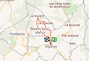
Tocht Stappen van 10,5 km beschikbaar op Provence-Alpes-Côte d'Azur, Alpes-de-Haute-Provence, Sigonce. Deze tocht wordt voorgesteld door RobinMicheline.
Beschrijving
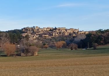
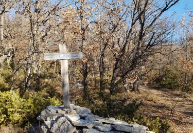
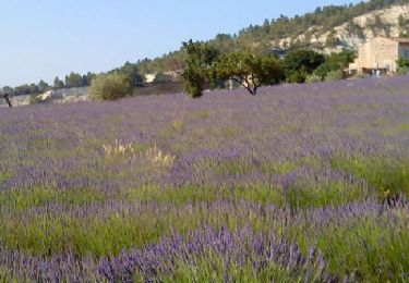
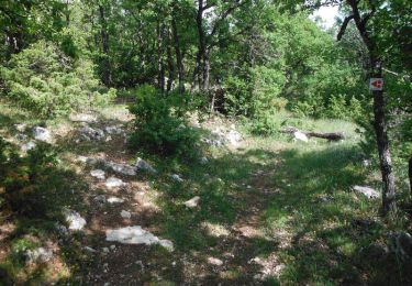
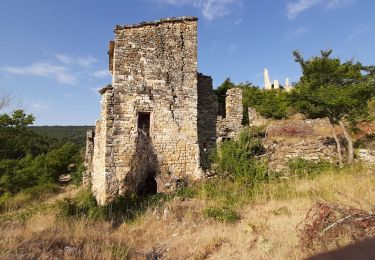
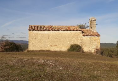
3 villages provençaux magnifiques. Sentier sympathique en bordure d eau magnifique 200 mns marche à refaire
Plaatsbepaling
Land:
France
Regio :
Provence-Alpes-Côte d'Azur
Departement/Provincie :
Alpes-de-Haute-Provence
Gemeente :
Sigonce
Locatie:
Unknown
Vertrek:(Dec)
Vertrek:(UTM)
727741 ; 4875506 (31T) N.
Opmerkingen
Wandeltochten in de omgeving
![Tocht Stappen Lurs - LURS Visite et tour de Lurs o l m s - Photo](https://media.geolcdn.com/t/375/260/3d026f2d-5050-4452-b35c-15ecc1ffb670.jpg&format=jpg&maxdim=2)
![Stappen Stappen](https://static1.geolcdn.com/sitytour/trail-icons/101.png)
LURS Visite et tour de Lurs o l m s
Stappen
Medium
(2)
Lurs,
Provence-Alpes-Côte d'Azur,
Alpes-de-Haute-Provence,
France
![](/images/other/stat-length.png)
11,1 km | 15,6 km-effort
3h 17min
![](https://static1.geolcdn.com/siteimages/upload/files/16400158638029165_repeat_loop_refresh_sync_direction_icon.png)
Ja
![Tocht Stappen Forcalquier - GR6 - Mère des Fontaines - Roche Ruine - Les Mourres - Photo](https://media.geolcdn.com/t/375/260/76cb3b2d-ea42-47ba-83f0-25484645e194.jpg&format=jpg&maxdim=2)
![Stappen Stappen](https://static1.geolcdn.com/sitytour/trail-icons/101.png)
GR6 - Mère des Fontaines - Roche Ruine - Les Mourres
Stappen
Gemakkelijk
(1)
Forcalquier,
Provence-Alpes-Côte d'Azur,
Alpes-de-Haute-Provence,
France
![](/images/other/stat-length.png)
18 km | 26 km-effort
4h 42min
![](https://static1.geolcdn.com/siteimages/upload/files/16400158638029165_repeat_loop_refresh_sync_direction_icon.png)
Ja
![Tocht Fiets Forcalquier - Parcours n°17 - Forcalquier - Photo](https://media.geolcdn.com/t/375/260/ext.jpg?maxdim=2&url=https%3A%2F%2Fservices.sitytrail.com%2FGeolivesWS%2FDownloadMedia.ashx%3FTrailID%3D375418%26Media%3D84c90ab1-7dbd-443e-924d-85d77bb4fdae.jpg)
![Fiets Fiets](https://static1.geolcdn.com/sitytour/trail-icons/200.png)
Parcours n°17 - Forcalquier
Fiets
Gemakkelijk
(1)
Forcalquier,
Provence-Alpes-Côte d'Azur,
Alpes-de-Haute-Provence,
France
![](/images/other/stat-length.png)
21 km | 25 km-effort
1h 28min
![](https://static1.geolcdn.com/siteimages/upload/files/16400158638029165_repeat_loop_refresh_sync_direction_icon.png)
Ja
![Tocht Mountainbike Forcalquier - La classique du Clot, circuit n°5 - Pays de Forcalquier - Photo](https://media.geolcdn.com/t/375/260/ext.jpg?maxdim=2&url=https%3A%2F%2Fservices.sitytrail.com%2FGeolivesWS%2FDownloadMedia.ashx%3FTrailID%3D214952%26Media%3D15520_2.jpg)
![Mountainbike Mountainbike](https://static1.geolcdn.com/sitytour/trail-icons/202.png)
La classique du Clot, circuit n°5 - Pays de Forcalquier
Mountainbike
Moeilijk
(1)
Forcalquier,
Provence-Alpes-Côte d'Azur,
Alpes-de-Haute-Provence,
France
![](/images/other/stat-length.png)
14,7 km | 20 km-effort
2h 0min
![](https://static1.geolcdn.com/siteimages/upload/files/16400158638029165_repeat_loop_refresh_sync_direction_icon.png)
Ja
![Tocht Stappen Saint-Étienne-les-Orgues - MONTLAUX. Le Revest. La Blache . Vieux Montlaux o l s - Photo](https://media.geolcdn.com/t/375/260/067d0493-31a9-484f-b222-caf0ca30ade9.jpg&format=jpg&maxdim=2)
![Stappen Stappen](https://static1.geolcdn.com/sitytour/trail-icons/101.png)
MONTLAUX. Le Revest. La Blache . Vieux Montlaux o l s
Stappen
Medium
Saint-Étienne-les-Orgues,
Provence-Alpes-Côte d'Azur,
Alpes-de-Haute-Provence,
France
![](/images/other/stat-length.png)
17,3 km | 23 km-effort
4h 39min
![](https://static1.geolcdn.com/siteimages/upload/files/16400158638029165_repeat_loop_refresh_sync_direction_icon.png)
Ja
![Tocht Te voet Lurs - LURS . bois du Crepon , Notre dame du Plan , la Casse o - Photo](https://media.geolcdn.com/t/375/260/6ee7fbee-7801-435a-8e10-37324f285717.jpg&format=jpg&maxdim=2)
![Te voet Te voet](https://static1.geolcdn.com/sitytour/trail-icons/100.png)
LURS . bois du Crepon , Notre dame du Plan , la Casse o
Te voet
Medium
Lurs,
Provence-Alpes-Côte d'Azur,
Alpes-de-Haute-Provence,
France
![](/images/other/stat-length.png)
14,3 km | 18,6 km-effort
Onbekend
![](https://static1.geolcdn.com/siteimages/upload/files/16400158638029165_repeat_loop_refresh_sync_direction_icon.png)
Ja
![Tocht Stappen Saint-Étienne-les-Orgues - St Etienne les Orgues - La Blache - Photo](https://media.geolcdn.com/t/375/260/ext.jpg?maxdim=2&url=https%3A%2F%2Fstatic1.geolcdn.com%2Fsiteimages%2Fupload%2Ffiles%2F1553511878bg_sport_marche.png)
![Stappen Stappen](https://static1.geolcdn.com/sitytour/trail-icons/101.png)
St Etienne les Orgues - La Blache
Stappen
Medium
(1)
Saint-Étienne-les-Orgues,
Provence-Alpes-Côte d'Azur,
Alpes-de-Haute-Provence,
France
![](/images/other/stat-length.png)
14,8 km | 19,3 km-effort
4h 16min
![](https://static1.geolcdn.com/siteimages/upload/files/16400158638029165_repeat_loop_refresh_sync_direction_icon.png)
Ja
![Tocht Mountainbike Lurs - Lurs/Tour de la Beaume - Photo](https://media.geolcdn.com/t/375/260/ext.jpg?maxdim=2&url=https%3A%2F%2Fstatic1.geolcdn.com%2Fsiteimages%2Fupload%2Ffiles%2F1524743154velo.jpg)
![Mountainbike Mountainbike](https://static1.geolcdn.com/sitytour/trail-icons/202.png)
Lurs/Tour de la Beaume
Mountainbike
Medium
(2)
Lurs,
Provence-Alpes-Côte d'Azur,
Alpes-de-Haute-Provence,
France
![](/images/other/stat-length.png)
18,5 km | 24 km-effort
2h 40min
![](https://static1.geolcdn.com/siteimages/upload/files/16400158638029165_repeat_loop_refresh_sync_direction_icon.png)
Ja
![Tocht Fiets Forcalquier - Le Pays de Forcalquier - Montagne de Lure à vélo - Photo](https://media.geolcdn.com/t/375/260/ext.jpg?maxdim=2&url=https%3A%2F%2Fservices.sitytrail.com%2FGeolivesWS%2FDownloadMedia.ashx%3FTrailID%3D375430%26Media%3D23b539a2-af76-456a-868b-6b919a4761e7.jpg)
![Fiets Fiets](https://static1.geolcdn.com/sitytour/trail-icons/200.png)
Le Pays de Forcalquier - Montagne de Lure à vélo
Fiets
Medium
Forcalquier,
Provence-Alpes-Côte d'Azur,
Alpes-de-Haute-Provence,
France
![](/images/other/stat-length.png)
81 km | 99 km-effort
5h 36min
![](https://static1.geolcdn.com/siteimages/upload/files/16400158638029165_repeat_loop_refresh_sync_direction_icon.png)
Ja