![](/images/other/stat-length.png)
![Tocht Stappen Blain - Blain Circuit du Perche - Photo](https://media.geolcdn.com/t/1900/400/ext.pjpeg?maxdim=2&url=https%3A%2F%2Fstatic1.geolcdn.com%2Fsiteimages%2Fupload%2Ffiles%2F1553511878bg_sport_marche.png)
Blain Circuit du Perche
phila128
Gebruiker
![Lengte](/images/other/stat-length.png)
Lengte
13,4 km
![Max. hoogte](https://static1.geolcdn.com/siteimages/upload/files/1508320355ic_sort_altitude_max_24dp.png)
Max. hoogte
32 m
![Positief hoogteverschil](https://static1.geolcdn.com/siteimages/upload/files/1508320355ic_sort_den_pos_24dp.png)
Positief hoogteverschil
79 m
![Km-Effort](/images/other/stat-length.png)
Km-Effort
14,5 km
![Min. hoogte](https://static1.geolcdn.com/siteimages/upload/files/1508320355ic_sort_altitude_min_24dp.png)
Min. hoogte
12 m
![Negatief hoogteverschil](https://static1.geolcdn.com/siteimages/upload/files/1508320355ic_sort_den_neg_24dp.png)
Negatief hoogteverschil
79 m
![Boucle](https://static1.geolcdn.com/siteimages/upload/files/16400158638029165_repeat_loop_refresh_sync_direction_icon.png)
Boucle
Ja
Datum van aanmaak :
2014-12-10 00:00:00.0
Laatste wijziging :
2014-12-10 00:00:00.0
![Stappen](https://static1.geolcdn.com/sitytour/trail-icons/101.png)
2h19
Moeilijkheid : Medium
![Scan deze QR-code om de tocht te openen in de SityTrail-applicatie](https://capi.geolives.com/qq0zvz2zws4bq2lad0pu/sitytour/trails/113527/qr.png?size=200)
Gratisgps-wandelapplicatie
Over ons
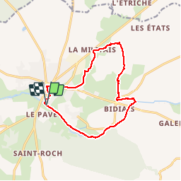
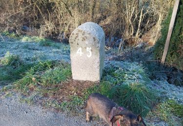
Tocht Stappen van 13,4 km beschikbaar op Pays de la Loire, Loire-Atlantique, Blain. Deze tocht wordt voorgesteld door phila128.
Beschrijving
Circuit du perche
Empruntant sur plusieurs kilomètres le chemin de halage, le long du canal de Nantes
à Brest, ce circuit vous fera découvrir aussi, à quelques enjambées des murs de la cité,
les sentiers bucoliques de la campagne blinoise…
Plaatsbepaling
Land:
France
Regio :
Pays de la Loire
Departement/Provincie :
Loire-Atlantique
Gemeente :
Blain
Locatie:
Unknown
Vertrek:(Dec)
Vertrek:(UTM)
593127 ; 5258047 (30T) N.
Opmerkingen
Wandeltochten in de omgeving
![Tocht Stappen Blain - la voie verte Blain à Bouvron - Photo](https://media.geolcdn.com/t/375/260/9575372d-80b3-4752-9809-040bdd99dc34.jpg&format=jpg&maxdim=2)
![Stappen Stappen](https://static1.geolcdn.com/sitytour/trail-icons/101.png)
la voie verte Blain à Bouvron
Stappen
Medium
Blain,
Pays de la Loire,
Loire-Atlantique,
France
![](/images/other/stat-length.png)
10,3 km | 11,1 km-effort
3h 6min
![](https://static1.geolcdn.com/siteimages/upload/files/16400158638029165_repeat_loop_refresh_sync_direction_icon.png)
Ja
![Tocht Stappen Blain - a Blain le canal de Nantes a Brest - Photo](https://media.geolcdn.com/t/375/260/9e25ddc8-a722-4a81-a513-2676b95639a1.jpg&format=jpg&maxdim=2)
![Stappen Stappen](https://static1.geolcdn.com/sitytour/trail-icons/101.png)
a Blain le canal de Nantes a Brest
Stappen
Medium
Blain,
Pays de la Loire,
Loire-Atlantique,
France
![](/images/other/stat-length.png)
10,3 km | 10,9 km-effort
2h 51min
![](https://static1.geolcdn.com/siteimages/upload/files/16400158638029165_repeat_loop_refresh_sync_direction_icon.png)
Ja
![Tocht Stappen Blain - 04.08.2019 - Autour de BLAIN - Photo](https://media.geolcdn.com/t/375/260/9a7f0eaa-8d83-4586-85a7-5277aa9453cf.jpg&format=jpg&maxdim=2)
![Stappen Stappen](https://static1.geolcdn.com/sitytour/trail-icons/101.png)
04.08.2019 - Autour de BLAIN
Stappen
Medium
Blain,
Pays de la Loire,
Loire-Atlantique,
France
![](/images/other/stat-length.png)
26 km | 0 m-effort
7h 19min
![](https://static1.geolcdn.com/siteimages/upload/files/16400158638029165_repeat_loop_refresh_sync_direction_icon.png)
Ja
![Tocht Auto Le Gâvre - 2024-12-21 Le Gavre RB - Photo](https://media.geolcdn.com/t/375/260/ext.jpg?maxdim=2&url=https%3A%2F%2Fstatic1.geolcdn.com%2Fsiteimages%2Fupload%2Ffiles%2F15247431544x4.jpg)
![Auto Auto](https://static1.geolcdn.com/sitytour/trail-icons/401.png)
2024-12-21 Le Gavre RB
Auto
Le Gâvre,
Pays de la Loire,
Loire-Atlantique,
France
![](/images/other/stat-length.png)
40 km | 45 km-effort
3h 50min
![](https://static1.geolcdn.com/siteimages/upload/files/16400158638029165_repeat_loop_refresh_sync_direction_icon.png)
Neen
![Tocht Stappen Blain - canal de Nantes a Brest à Blain - Photo](https://media.geolcdn.com/t/375/260/b7f2687e-764a-49f8-b692-08e180e2b84e.jpg&format=jpg&maxdim=2)
![Stappen Stappen](https://static1.geolcdn.com/sitytour/trail-icons/101.png)
canal de Nantes a Brest à Blain
Stappen
Medium
Blain,
Pays de la Loire,
Loire-Atlantique,
France
![](/images/other/stat-length.png)
10,3 km | 10,8 km-effort
2h 50min
![](https://static1.geolcdn.com/siteimages/upload/files/16400158638029165_repeat_loop_refresh_sync_direction_icon.png)
Ja
![Tocht Auto Le Gâvre - 2023-12-26 Le Gavre RB - Photo](https://media.geolcdn.com/t/375/260/ext.jpg?maxdim=2&url=https%3A%2F%2Fstatic1.geolcdn.com%2Fsiteimages%2Fupload%2Ffiles%2F15247431544x4.jpg)
![Auto Auto](https://static1.geolcdn.com/sitytour/trail-icons/401.png)
2023-12-26 Le Gavre RB
Auto
Le Gâvre,
Pays de la Loire,
Loire-Atlantique,
France
![](/images/other/stat-length.png)
35 km | 39 km-effort
2h 22min
![](https://static1.geolcdn.com/siteimages/upload/files/16400158638029165_repeat_loop_refresh_sync_direction_icon.png)
Neen
![Tocht Auto Le Gâvre - 2023-12-8 Le Gavre R B - Photo](https://media.geolcdn.com/t/375/260/ext.jpg?maxdim=2&url=https%3A%2F%2Fstatic1.geolcdn.com%2Fsiteimages%2Fupload%2Ffiles%2F15247431544x4.jpg)
![Auto Auto](https://static1.geolcdn.com/sitytour/trail-icons/401.png)
2023-12-8 Le Gavre R B
Auto
Le Gâvre,
Pays de la Loire,
Loire-Atlantique,
France
![](/images/other/stat-length.png)
56 km | 64 km-effort
3h 44min
![](https://static1.geolcdn.com/siteimages/upload/files/16400158638029165_repeat_loop_refresh_sync_direction_icon.png)
Neen
![Tocht Wegfiets Blain - Blain gare de Nantes étape 6 - Photo](https://media.geolcdn.com/t/375/260/ext.jpg?maxdim=2&url=https%3A%2F%2Fstatic1.geolcdn.com%2Fsiteimages%2Fupload%2Ffiles%2F1524743154velo.jpg)
![Wegfiets Wegfiets](https://static1.geolcdn.com/sitytour/trail-icons/201.png)
Blain gare de Nantes étape 6
Wegfiets
Heel gemakkelijk
Blain,
Pays de la Loire,
Loire-Atlantique,
France
![](/images/other/stat-length.png)
55 km | 60 km-effort
4h 11min
![](https://static1.geolcdn.com/siteimages/upload/files/16400158638029165_repeat_loop_refresh_sync_direction_icon.png)
Neen
![Tocht Fietstoerisme Blain - Vélo - Blain - Guenrouet - 47 km - Photo](https://media.geolcdn.com/t/375/260/ext.jpg?maxdim=2&url=https%3A%2F%2Fstatic1.geolcdn.com%2Fsiteimages%2Fupload%2Ffiles%2F1524743154velo.jpg)
![Fietstoerisme Fietstoerisme](https://static1.geolcdn.com/sitytour/trail-icons/204.png)
Vélo - Blain - Guenrouet - 47 km
Fietstoerisme
Zeer moeilijk
Blain,
Pays de la Loire,
Loire-Atlantique,
France
![](/images/other/stat-length.png)
48 km | 51 km-effort
Onbekend
![](https://static1.geolcdn.com/siteimages/upload/files/16400158638029165_repeat_loop_refresh_sync_direction_icon.png)
Ja