![](/images/other/stat-length.png)
![Tocht Stappen Peyrolles - Sentier de la Diligence - Peyrolles - Photo](https://media.geolcdn.com/t/1900/400/ext.pjpeg?maxdim=2&url=https%3A%2F%2Fservices.sitytrail.com%2FGeolivesWS%2FDownloadMedia.ashx%3FTrailID%3D112890%26Media%3D12796_5.jpg)
Sentier de la Diligence - Peyrolles
tracegps
Gebruiker
![Lengte](/images/other/stat-length.png)
![Max. hoogte](https://static1.geolcdn.com/siteimages/upload/files/1508320355ic_sort_altitude_max_24dp.png)
![Positief hoogteverschil](https://static1.geolcdn.com/siteimages/upload/files/1508320355ic_sort_den_pos_24dp.png)
![Km-Effort](/images/other/stat-length.png)
![Min. hoogte](https://static1.geolcdn.com/siteimages/upload/files/1508320355ic_sort_altitude_min_24dp.png)
![Negatief hoogteverschil](https://static1.geolcdn.com/siteimages/upload/files/1508320355ic_sort_den_neg_24dp.png)
![Boucle](https://static1.geolcdn.com/siteimages/upload/files/16400158638029165_repeat_loop_refresh_sync_direction_icon.png)
![Stappen](https://static1.geolcdn.com/sitytour/trail-icons/101.png)
5h00
Moeilijkheid : Zeer moeilijk
![Scan deze QR-code om de tocht te openen in de SityTrail-applicatie](https://capi.geolives.com/qq0zvz2zws4bq2lad0pu/sitytour/trails/112890/qr.png?size=200)
Gratisgps-wandelapplicatie
Over ons
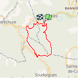
Tocht Stappen van 14,3 km beschikbaar op Occitanië, Gard, Peyrolles. Deze tocht wordt voorgesteld door tracegps.
Beschrijving
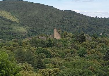
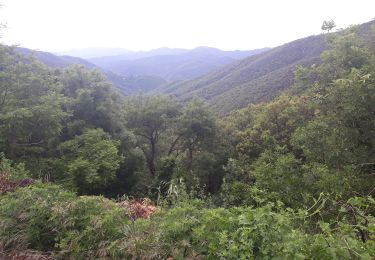
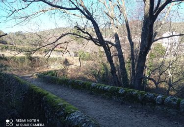
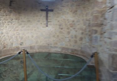
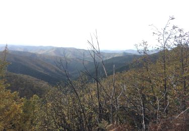
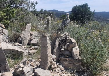
Circuit proposé par l'Office de Tourisme de la Vallée Borgne. Vos pas vont vous guider au travers de cette balade au sein de l’histoire des Cévennes, celle d’une vie rurale aussi rude qu’intense voire ingrate forgeant un esprit grégaire de résistance. Ici, lieux-dits, château, maison de maître, bâtisse en schiste vous raconteront la vaillante défense d’hommes et de femmes pour préserver leur liberté de croyance. Départ du virage de la Planque à Peyrolles. La pochette de 15 circuits balisés est en vente (5€) à l’Office de Tourisme de la Vallée Borgne. L’Office de Tourisme est ouvert toute l'année. Vous trouverez sur place de quoi se restaurer et dormir.
Plaatsbepaling
Opmerkingen
Wandeltochten in de omgeving
![Tocht Stappen Saint-Jean-du-Gard - rocher des chèvres - Photo](https://media.geolcdn.com/t/375/260/f651fafb-b1d1-4725-b624-a9394b90fcdc.jpg&format=jpg&maxdim=2)
![Stappen Stappen](https://static1.geolcdn.com/sitytour/trail-icons/101.png)
Stappen
![](/images/other/stat-length.png)
![](https://static1.geolcdn.com/siteimages/upload/files/16400158638029165_repeat_loop_refresh_sync_direction_icon.png)
![Tocht Stappen Saint-Jean-du-Gard - Signal Saint Pierre - Photo](https://media.geolcdn.com/t/375/260/c97a240b-eff8-49fc-8022-a55a2f6c33fc.jpg&format=jpg&maxdim=2)
![Stappen Stappen](https://static1.geolcdn.com/sitytour/trail-icons/101.png)
Stappen
![](/images/other/stat-length.png)
![](https://static1.geolcdn.com/siteimages/upload/files/16400158638029165_repeat_loop_refresh_sync_direction_icon.png)
![Tocht Stappen Soudorgues - Vallée Salindrenque - Photo](https://media.geolcdn.com/t/375/260/cdaa973a-fc3c-410e-b572-e43390419aac.jpg&format=jpg&maxdim=2)
![Stappen Stappen](https://static1.geolcdn.com/sitytour/trail-icons/101.png)
Stappen
![](/images/other/stat-length.png)
![](https://static1.geolcdn.com/siteimages/upload/files/16400158638029165_repeat_loop_refresh_sync_direction_icon.png)
![Tocht Stappen Peyrolles - la Diligence - Photo](https://media.geolcdn.com/t/375/260/586b4281-ee2f-4585-9155-506814e7d72d.jpg&format=jpg&maxdim=2)
![Stappen Stappen](https://static1.geolcdn.com/sitytour/trail-icons/101.png)
![Tocht Stappen Soudorgues - 30 le mauripe 12/01/25 - Photo](https://media.geolcdn.com/t/375/260/c58da66e-da90-432e-9b8e-79a3a5c374cc.jpg&format=jpg&maxdim=2)
![Stappen Stappen](https://static1.geolcdn.com/sitytour/trail-icons/101.png)
Stappen
![](/images/other/stat-length.png)
![](https://static1.geolcdn.com/siteimages/upload/files/16400158638029165_repeat_loop_refresh_sync_direction_icon.png)
![Tocht Stappen Sainte-Croix-de-Caderle - Sainte croix de caderne - Photo](https://media.geolcdn.com/t/375/260/ba9120ca-f6c8-4e17-a730-5e8fa60dbcd0.jpg&format=jpg&maxdim=2)
![Stappen Stappen](https://static1.geolcdn.com/sitytour/trail-icons/101.png)
Stappen
![](/images/other/stat-length.png)
![](https://static1.geolcdn.com/siteimages/upload/files/16400158638029165_repeat_loop_refresh_sync_direction_icon.png)
![Tocht Stappen L'Estréchure - sentier du soult - - Photo](https://media.geolcdn.com/t/375/260/a964cc92-5537-4fc7-831f-28f7bdbf37f2.jpg&format=jpg&maxdim=2)
![Stappen Stappen](https://static1.geolcdn.com/sitytour/trail-icons/101.png)
Stappen
![](/images/other/stat-length.png)
![](https://static1.geolcdn.com/siteimages/upload/files/16400158638029165_repeat_loop_refresh_sync_direction_icon.png)
![Tocht Stappen Saint-Jean-du-Gard - 17-05-2023 E12 Saint Jean du Gard - Ales - Photo](https://media.geolcdn.com/t/375/260/1d8b4717-c204-41b3-a27c-5a1aef561e2f.jpg&format=jpg&maxdim=2)
![Stappen Stappen](https://static1.geolcdn.com/sitytour/trail-icons/101.png)
Stappen
![](/images/other/stat-length.png)
![](https://static1.geolcdn.com/siteimages/upload/files/16400158638029165_repeat_loop_refresh_sync_direction_icon.png)
![Tocht Stappen Soudorgues - La Vallée Borgne - Photo](https://media.geolcdn.com/t/375/260/fc66911e-f8e1-402c-a199-faceb474f5bb.jpg&format=jpg&maxdim=2)
![Stappen Stappen](https://static1.geolcdn.com/sitytour/trail-icons/101.png)
Stappen
![](/images/other/stat-length.png)
![](https://static1.geolcdn.com/siteimages/upload/files/16400158638029165_repeat_loop_refresh_sync_direction_icon.png)