![](/images/other/stat-length.png)
![Tocht Stappen Montépilloy - Une grande échappée - Montépilloy - Photo](https://media.geolcdn.com/t/1900/400/ext.pjpeg?maxdim=2&url=https%3A%2F%2Fservices.sitytrail.com%2FGeolivesWS%2FDownloadMedia.ashx%3FTrailID%3D112870%26Media%3D12752_5.jpg)
Une grande échappée - Montépilloy
tracegps
Gebruiker
![Lengte](/images/other/stat-length.png)
![Max. hoogte](https://static1.geolcdn.com/siteimages/upload/files/1508320355ic_sort_altitude_max_24dp.png)
![Positief hoogteverschil](https://static1.geolcdn.com/siteimages/upload/files/1508320355ic_sort_den_pos_24dp.png)
![Km-Effort](/images/other/stat-length.png)
![Min. hoogte](https://static1.geolcdn.com/siteimages/upload/files/1508320355ic_sort_altitude_min_24dp.png)
![Negatief hoogteverschil](https://static1.geolcdn.com/siteimages/upload/files/1508320355ic_sort_den_neg_24dp.png)
![Boucle](https://static1.geolcdn.com/siteimages/upload/files/16400158638029165_repeat_loop_refresh_sync_direction_icon.png)
![Stappen](https://static1.geolcdn.com/sitytour/trail-icons/101.png)
2h30
Moeilijkheid : Medium
![Scan deze QR-code om de tocht te openen in de SityTrail-applicatie](https://capi.geolives.com/qq0zvz2zws4bq2lad0pu/sitytour/trails/112870/qr.png?size=200)
Gratisgps-wandelapplicatie
Over ons
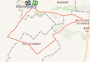
Tocht Stappen van 9,7 km beschikbaar op Hauts-de-France, Oise, Montépilloy. Deze tocht wordt voorgesteld door tracegps.
Beschrijving
Circuit proposé par le Parc Naturel régional Oise – Pays de France. Les romains nommèrent ce site stratégique, Mons Expellericus pour ses qualités de guet. Sentinelle déchue, le formidable donjon de Montépilloy (45 m de haut), bâti au 12e siècle, domine toute la plaine du Valois et se souvient encore de sa gloire passée, lorsque Jeanne d’Arc, de retour du couronnement de Charles VII à Reims, bâtit les Anglais sous ses murs en 1429. Départ : Parking du cimetière de Montépilloy, Retrouvez le circuit sur le site du Parc Naturel régional Oise – Pays de France.
Plaatsbepaling
Opmerkingen
Wandeltochten in de omgeving
![Tocht Stappen Villers-Saint-Frambourg-Ognon - MR_OGNON (par BALAGNY-sur-AUNETTE)_5.4Km - Photo](https://media.geolcdn.com/t/375/260/faa42a0c-203b-4c6a-9068-84728c6debbe.jpg&format=jpg&maxdim=2)
![Stappen Stappen](https://static1.geolcdn.com/sitytour/trail-icons/101.png)
Stappen
![](/images/other/stat-length.png)
![](https://static1.geolcdn.com/siteimages/upload/files/16400158638029165_repeat_loop_refresh_sync_direction_icon.png)
![Tocht Stappen Mont-l'Évêque - SM_MONT-L'EVEQUE_8Km - Photo](https://media.geolcdn.com/t/375/260/c5d9fe69-6f06-4add-9173-2e50cb01e4b9.jpg&format=jpg&maxdim=2)
![Stappen Stappen](https://static1.geolcdn.com/sitytour/trail-icons/101.png)
Stappen
![](/images/other/stat-length.png)
![](https://static1.geolcdn.com/siteimages/upload/files/16400158638029165_repeat_loop_refresh_sync_direction_icon.png)
![Tocht Stappen Montlognon - MR_MONTLOGNON(Cimetière)_6.1Km - Photo](https://media.geolcdn.com/t/375/260/d96d860c-7d87-44a8-97b3-4eeb3f0b2c5f.jpg&format=jpg&maxdim=2)
![Stappen Stappen](https://static1.geolcdn.com/sitytour/trail-icons/101.png)
Stappen
![](/images/other/stat-length.png)
![](https://static1.geolcdn.com/siteimages/upload/files/16400158638029165_repeat_loop_refresh_sync_direction_icon.png)
![Tocht Stappen Borest - SM_BOREST SUD_8Km - Photo](https://media.geolcdn.com/t/375/260/27f1e0b4-8312-4412-80d8-e928b28ed5d3.jpg&format=jpg&maxdim=2)
![Stappen Stappen](https://static1.geolcdn.com/sitytour/trail-icons/101.png)
Stappen
![](/images/other/stat-length.png)
![](https://static1.geolcdn.com/siteimages/upload/files/16400158638029165_repeat_loop_refresh_sync_direction_icon.png)
![Tocht Stappen Montlognon - SM_MONTLOGNON_8.7Km - Photo](https://media.geolcdn.com/t/375/260/272c7bd3-6ff5-4f27-9728-c601d30b178f.jpg&format=jpg&maxdim=2)
![Stappen Stappen](https://static1.geolcdn.com/sitytour/trail-icons/101.png)
Stappen
![](/images/other/stat-length.png)
![](https://static1.geolcdn.com/siteimages/upload/files/16400158638029165_repeat_loop_refresh_sync_direction_icon.png)
![Tocht Stappen Borest - V&D_BOREST-SUD_9.3Km - Photo](https://media.geolcdn.com/t/375/260/dac00e57-fc57-4e0e-8dc5-f670942f21e7.jpg&format=jpg&maxdim=2)
![Stappen Stappen](https://static1.geolcdn.com/sitytour/trail-icons/101.png)
Stappen
![](/images/other/stat-length.png)
![](https://static1.geolcdn.com/siteimages/upload/files/16400158638029165_repeat_loop_refresh_sync_direction_icon.png)
![Tocht Stappen Montépilloy - Montépilloy Supermini Rando - Photo](https://media.geolcdn.com/t/375/260/ext.jpg?maxdim=2&url=https%3A%2F%2Fstatic1.geolcdn.com%2Fsiteimages%2Fupload%2Ffiles%2F1553511878bg_sport_marche.png)
![Stappen Stappen](https://static1.geolcdn.com/sitytour/trail-icons/101.png)
Stappen
![](/images/other/stat-length.png)
![](https://static1.geolcdn.com/siteimages/upload/files/16400158638029165_repeat_loop_refresh_sync_direction_icon.png)
![Tocht Noords wandelen Montlognon - MONTLOGNON MN - Photo](https://media.geolcdn.com/t/375/260/ext.jpg?maxdim=2&url=https%3A%2F%2Fstatic1.geolcdn.com%2Fsiteimages%2Fupload%2Ffiles%2F1545311037marcheuse_200dpi.jpg)
![Noords wandelen Noords wandelen](https://static1.geolcdn.com/sitytour/trail-icons/102.png)
Noords wandelen
![](/images/other/stat-length.png)
![](https://static1.geolcdn.com/siteimages/upload/files/16400158638029165_repeat_loop_refresh_sync_direction_icon.png)
![Tocht Stappen Villers-Saint-Frambourg-Ognon - SM_OGNON-(ex BALAGNY-sur-AUNETTE)_8.3Km - Photo](https://media.geolcdn.com/t/375/260/8470847c-163d-447b-bdc6-109cb2fcebb6.jpg&format=jpg&maxdim=2)
![Stappen Stappen](https://static1.geolcdn.com/sitytour/trail-icons/101.png)
Stappen
![](/images/other/stat-length.png)
![](https://static1.geolcdn.com/siteimages/upload/files/16400158638029165_repeat_loop_refresh_sync_direction_icon.png)