![](/images/other/stat-length.png)
![Tocht Stappen Villers-sur-Mer - Sentier nature de Blonville-Villers-sur-Mer - Photo](https://media.geolcdn.com/t/1900/400/ext.pjpeg?maxdim=2&url=https%3A%2F%2Fstatic1.geolcdn.com%2Fsiteimages%2Fupload%2Ffiles%2F1553511878bg_sport_marche.png)
Sentier nature de Blonville-Villers-sur-Mer
neoroll44
Gebruiker
![Lengte](/images/other/stat-length.png)
![Max. hoogte](https://static1.geolcdn.com/siteimages/upload/files/1508320355ic_sort_altitude_max_24dp.png)
![Positief hoogteverschil](https://static1.geolcdn.com/siteimages/upload/files/1508320355ic_sort_den_pos_24dp.png)
![Km-Effort](/images/other/stat-length.png)
![Min. hoogte](https://static1.geolcdn.com/siteimages/upload/files/1508320355ic_sort_altitude_min_24dp.png)
![Negatief hoogteverschil](https://static1.geolcdn.com/siteimages/upload/files/1508320355ic_sort_den_neg_24dp.png)
![Boucle](https://static1.geolcdn.com/siteimages/upload/files/16400158638029165_repeat_loop_refresh_sync_direction_icon.png)
![Stappen](https://static1.geolcdn.com/sitytour/trail-icons/101.png)
1h10
Moeilijkheid : Gemakkelijk
![Scan deze QR-code om de tocht te openen in de SityTrail-applicatie](https://capi.geolives.com/qq0zvz2zws4bq2lad0pu/sitytour/trails/1128672/qr.png?size=200)
Gratisgps-wandelapplicatie
Over ons
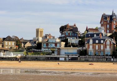
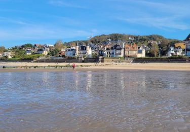
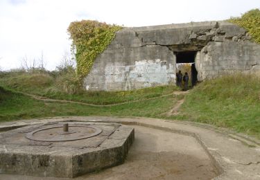
Tocht Stappen van 4,7 km beschikbaar op Normandië, Calvados, Villers-sur-Mer. Deze tocht wordt voorgesteld door neoroll44.
Beschrijving
Ces marais s'étendent sur près de 120 ha et offrent aux oiseaux un lieu de quiétude pour leur nidification. Depuis quelques années, des Cigognes blanches viennent même y nicher, une plate-forme pour faciliter leur nidification a d'ailleurs été installée en leur faveur.
1. Au parking prendre à gauche traverser la passerelle en bois, suivre le cheminement à droite.
2. A 260 m, traverser une seconde passerelle suivre le chemin à gauche et rester sur ce chemin.
3. A 1200 m prendre à droite.
4. A 300 m prendre de nouveau à droite.
5. A 600 m prendre encore à droite et longer la voie ferrée.
6. A 500 m au croisement prendre à droite.
7. A 800 m prendre la seconde entrée à droite. Suivre le cheminement et longer le plan d’eau jusqu’à retrouver le Paléospace.
Plaatsbepaling
Opmerkingen
Wandeltochten in de omgeving
![Tocht Noords wandelen Villers-sur-Mer - Marche nordique à Villers - Photo](https://media.geolcdn.com/t/375/260/6226f26b-d466-49bf-bd9e-63735f2d0e48.jpg&format=jpg&maxdim=2)
![Noords wandelen Noords wandelen](https://static1.geolcdn.com/sitytour/trail-icons/102.png)
Noords wandelen
![](/images/other/stat-length.png)
![](https://static1.geolcdn.com/siteimages/upload/files/16400158638029165_repeat_loop_refresh_sync_direction_icon.png)
![Tocht Stappen Tourgéville - Combo rando et marche nordique à Deauville - Photo](https://media.geolcdn.com/t/375/260/1cbe3e1b-1ac9-42b1-922c-ffa4710baf9e.jpg&format=jpg&maxdim=2)
![Stappen Stappen](https://static1.geolcdn.com/sitytour/trail-icons/101.png)
Stappen
![](/images/other/stat-length.png)
![](https://static1.geolcdn.com/siteimages/upload/files/16400158638029165_repeat_loop_refresh_sync_direction_icon.png)
![Tocht Stappen Blonville-sur-Mer - Blonville 2 - Photo](https://media.geolcdn.com/t/375/260/ext.jpg?maxdim=2&url=https%3A%2F%2Fstatic1.geolcdn.com%2Fsiteimages%2Fupload%2Ffiles%2F1553511878bg_sport_marche.png)
![Stappen Stappen](https://static1.geolcdn.com/sitytour/trail-icons/101.png)
Stappen
![](/images/other/stat-length.png)
![](https://static1.geolcdn.com/siteimages/upload/files/16400158638029165_repeat_loop_refresh_sync_direction_icon.png)
![Tocht Stappen Villers-sur-Mer - Villers Sur mer - Photo](https://media.geolcdn.com/t/375/260/ext.jpg?maxdim=2&url=https%3A%2F%2Fstatic1.geolcdn.com%2Fsiteimages%2Fupload%2Ffiles%2F1553511878bg_sport_marche.png)
![Stappen Stappen](https://static1.geolcdn.com/sitytour/trail-icons/101.png)
Stappen
![](/images/other/stat-length.png)
![](https://static1.geolcdn.com/siteimages/upload/files/16400158638029165_repeat_loop_refresh_sync_direction_icon.png)
![Tocht Stappen Deauville - Deauville Touques - Photo](https://media.geolcdn.com/t/375/260/136159d3-b713-4353-8bbb-32ce408ea371.jpg&format=jpg&maxdim=2)
![Stappen Stappen](https://static1.geolcdn.com/sitytour/trail-icons/101.png)
Stappen
![](/images/other/stat-length.png)
![](https://static1.geolcdn.com/siteimages/upload/files/16400158638029165_repeat_loop_refresh_sync_direction_icon.png)
![Tocht Stappen Deauville - Deauville Honfleur - Photo](https://media.geolcdn.com/t/375/260/748fa480-642e-4254-b5e3-ecc7ff0f518c.jpg&format=jpg&maxdim=2)
![Stappen Stappen](https://static1.geolcdn.com/sitytour/trail-icons/101.png)
Stappen
![](/images/other/stat-length.png)
![](https://static1.geolcdn.com/siteimages/upload/files/16400158638029165_repeat_loop_refresh_sync_direction_icon.png)
![Tocht Te voet Houlgate - Le Tour de Houlgate - Photo](https://media.geolcdn.com/t/375/260/74da37b6-10f7-4439-a616-263f3c86680c.jpeg&format=jpg&maxdim=2)
![Te voet Te voet](https://static1.geolcdn.com/sitytour/trail-icons/100.png)
Te voet
![](/images/other/stat-length.png)
![](https://static1.geolcdn.com/siteimages/upload/files/16400158638029165_repeat_loop_refresh_sync_direction_icon.png)
![Stappen Stappen](https://static1.geolcdn.com/sitytour/trail-icons/101.png)
Stappen
![](/images/other/stat-length.png)
![](https://static1.geolcdn.com/siteimages/upload/files/16400158638029165_repeat_loop_refresh_sync_direction_icon.png)
![Tocht Stappen Tourgéville - CRAB : Tourgéville - Deauville - Photo](https://media.geolcdn.com/t/375/260/ext.jpg?maxdim=2&url=https%3A%2F%2Fservices.sitytrail.com%2FGeolivesWS%2FDownloadMedia.ashx%3FTrailID%3D838396%26Media%3Dfix__20171001160914.jpg)
![Stappen Stappen](https://static1.geolcdn.com/sitytour/trail-icons/101.png)
Stappen
![](/images/other/stat-length.png)
![](https://static1.geolcdn.com/siteimages/upload/files/16400158638029165_repeat_loop_refresh_sync_direction_icon.png)