![](/images/other/stat-length.png)
![Tocht Stappen Bouvante - GTV - Tour du Vercors à pied - Font d'Urle - Léoncel - Photo](https://media.geolcdn.com/t/1900/400/ext.pjpeg?maxdim=2&url=https%3A%2F%2Fservices.sitytrail.com%2FGeolivesWS%2FDownloadMedia.ashx%3FTrailID%3D112699%26Media%3D11552_2.jpg)
GTV - Tour du Vercors à pied - Font d'Urle - Léoncel
tracegps
Gebruiker
![Lengte](/images/other/stat-length.png)
![Max. hoogte](https://static1.geolcdn.com/siteimages/upload/files/1508320355ic_sort_altitude_max_24dp.png)
![Positief hoogteverschil](https://static1.geolcdn.com/siteimages/upload/files/1508320355ic_sort_den_pos_24dp.png)
![Km-Effort](/images/other/stat-length.png)
![Min. hoogte](https://static1.geolcdn.com/siteimages/upload/files/1508320355ic_sort_altitude_min_24dp.png)
![Negatief hoogteverschil](https://static1.geolcdn.com/siteimages/upload/files/1508320355ic_sort_den_neg_24dp.png)
![Boucle](https://static1.geolcdn.com/siteimages/upload/files/16400158638029165_repeat_loop_refresh_sync_direction_icon.png)
![Stappen](https://static1.geolcdn.com/sitytour/trail-icons/101.png)
11h19
Moeilijkheid : Moeilijk
![Scan deze QR-code om de tocht te openen in de SityTrail-applicatie](https://capi.geolives.com/qq0zvz2zws4bq2lad0pu/sitytour/trails/112699/qr.png?size=200)
Gratisgps-wandelapplicatie
Over ons
Tocht Stappen van 30 km beschikbaar op Auvergne-Rhône-Alpes, Drôme, Bouvante. Deze tocht wordt voorgesteld door tracegps.
Beschrijving
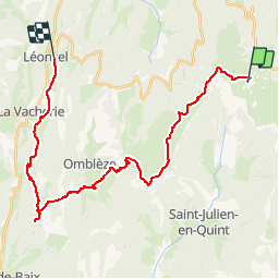
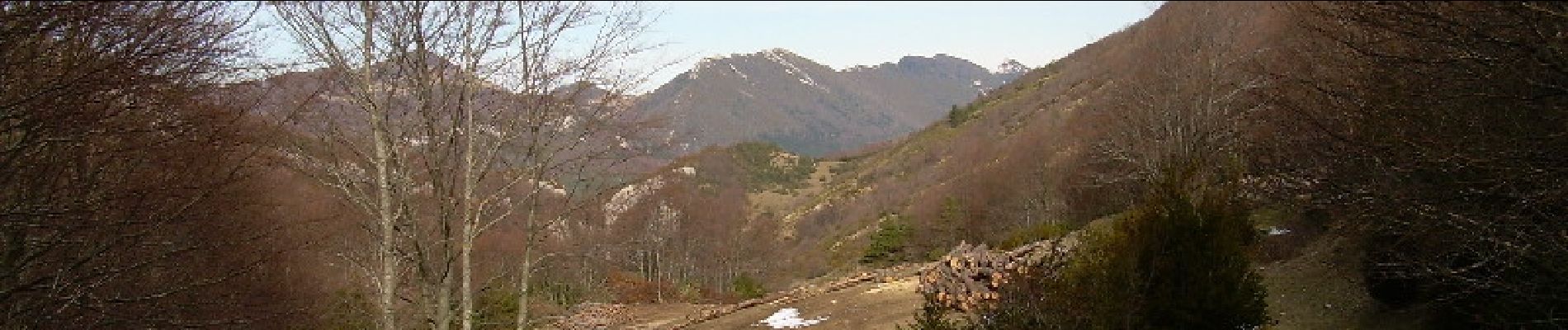
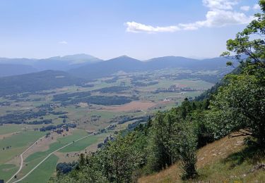
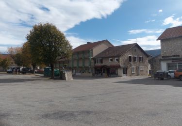
GTV - Tour du Vercors à pied - Font d'Urle – Léoncel. L’itinéraire traverse les beaux pâturages du plateau d’Ambel et monte jusqu’à la tête de la Dame, à 1506 mètres d’altitude. Aucune difficulté par beau temps, mais en cas de brouillard, l’orientation peut devenir problématique à cause de nombreuses sentes créées par le bétail. Laissant sur la droite le roc de Toulau qui veille sur le plateau d’Ambel, la GTV parcourt la commune d’Omblèze, un village composé de plusieurs hameaux. Puis l’itinéraire emprunte une petite route goudronnée qui se faufile dans les magnifiques Gorges d’Omblèze, à la fraicheur bien agréable en été. Ensuite, c’est à nouveau un sentier qui remonte vers le village de La Vacherie. Ce tronçon présente un mélange de végétation méditerranéenne et plus septentrionale. Tracé officiel labellisé GTV. Le découpage proposé est indicatif et les tronçons ne sont pas imposés. Construisez autour votre propre itinéraire en fonction de votre forme physique et des conditions climatiques. Pour vous aider, consultez les informations de Vercors-GTV.com et retrouvez les itinéraires en détail dans les topo-guides du Parc.
Plaatsbepaling
Opmerkingen
Wandeltochten in de omgeving
![Tocht Sneeuwschoenen Bouvante - Les gagères en raquettes - Photo](https://media.geolcdn.com/t/375/260/2981cf80-2281-48d0-9011-dd17ca071224.jpg&format=jpg&maxdim=2)
![Sneeuwschoenen Sneeuwschoenen](https://static1.geolcdn.com/sitytour/trail-icons/504.png)
Sneeuwschoenen
![](/images/other/stat-length.png)
![](https://static1.geolcdn.com/siteimages/upload/files/16400158638029165_repeat_loop_refresh_sync_direction_icon.png)
![Tocht Stappen Bouvante - 01 - Photo](https://media.geolcdn.com/t/375/260/ext.jpg?maxdim=2&url=https%3A%2F%2Fservices.sitytrail.com%2FGeolivesWS%2FDownloadMedia.ashx%3FTrailID%3D835352%26Media%3Dfix__20170924162337.jpg)
![Stappen Stappen](https://static1.geolcdn.com/sitytour/trail-icons/101.png)
Stappen
![](/images/other/stat-length.png)
![](https://static1.geolcdn.com/siteimages/upload/files/16400158638029165_repeat_loop_refresh_sync_direction_icon.png)
![Tocht Stappen Bouvante - 26 bouvante pas ligue st truite - Photo](https://media.geolcdn.com/t/375/260/9494233e-7248-475d-add1-20018e6bbb97.jpg&format=jpg&maxdim=2)
![Stappen Stappen](https://static1.geolcdn.com/sitytour/trail-icons/101.png)
Stappen
![](/images/other/stat-length.png)
![](https://static1.geolcdn.com/siteimages/upload/files/16400158638029165_repeat_loop_refresh_sync_direction_icon.png)
![Tocht Stappen La Chapelle-en-Vercors - Serre Plumé - Photo](https://media.geolcdn.com/t/375/260/86da3767-95d8-4e79-b2dd-2495b2dc9585.jpg&format=jpg&maxdim=2)
![Stappen Stappen](https://static1.geolcdn.com/sitytour/trail-icons/101.png)
Stappen
![](/images/other/stat-length.png)
![](https://static1.geolcdn.com/siteimages/upload/files/16400158638029165_repeat_loop_refresh_sync_direction_icon.png)
![Tocht Stappen La Chapelle-en-Vercors - serre plumé depuis carri par la bournette col de la baume grange de vauneyre col de la mure puis les cretes jusqu a pré bellet refuge de crobache lievre blanc scialet royer - Photo](https://media.geolcdn.com/t/375/260/82d39288-8889-4dde-9abf-27f32f728f38.jpg&format=jpg&maxdim=2)
![Stappen Stappen](https://static1.geolcdn.com/sitytour/trail-icons/101.png)
Stappen
![](/images/other/stat-length.png)
![](https://static1.geolcdn.com/siteimages/upload/files/16400158638029165_repeat_loop_refresh_sync_direction_icon.png)
![Tocht Stappen Bouvante - Boucle du Plateau de Font d'Urle - Photo](https://media.geolcdn.com/t/375/260/50aac9f1-41c9-480c-904d-17b530d5dbff.jpg&format=jpg&maxdim=2)
![Stappen Stappen](https://static1.geolcdn.com/sitytour/trail-icons/101.png)
Stappen
![](/images/other/stat-length.png)
![](https://static1.geolcdn.com/siteimages/upload/files/16400158638029165_repeat_loop_refresh_sync_direction_icon.png)
![Tocht Stappen Vassieux-en-Vercors - Vassieux-en-Vercors - Le Puy de la Gagère - Photo](https://media.geolcdn.com/t/375/260/1aad13f5-10ee-4304-b0fb-5635099ff701.jpg&format=jpg&maxdim=2)
![Stappen Stappen](https://static1.geolcdn.com/sitytour/trail-icons/101.png)
Stappen
![](/images/other/stat-length.png)
![](https://static1.geolcdn.com/siteimages/upload/files/16400158638029165_repeat_loop_refresh_sync_direction_icon.png)
![Tocht Stappen Bouvante - Font d’Urle les Trois cloches Glacières les Gagères - Photo](https://media.geolcdn.com/t/375/260/d811593c-e678-4b00-a285-b7dce29eecce.jpg&format=jpg&maxdim=2)
![Stappen Stappen](https://static1.geolcdn.com/sitytour/trail-icons/101.png)
Stappen
![](/images/other/stat-length.png)
![](https://static1.geolcdn.com/siteimages/upload/files/16400158638029165_repeat_loop_refresh_sync_direction_icon.png)
![Tocht Stappen Vassieux-en-Vercors - But St Genis - Photo](https://media.geolcdn.com/t/375/260/7dc5994c-58ff-4977-a518-836cfc09796c.jpg&format=jpg&maxdim=2)
![Stappen Stappen](https://static1.geolcdn.com/sitytour/trail-icons/101.png)
Stappen
![](/images/other/stat-length.png)
![](https://static1.geolcdn.com/siteimages/upload/files/16400158638029165_repeat_loop_refresh_sync_direction_icon.png)