![](/images/other/stat-length.png)
![Tocht Stappen Châtillon-en-Diois - GTV - Tour du Vercors à pied - Les Nonnières - Châtillon en Diois - Photo](https://media.geolcdn.com/t/1900/400/ext.pjpeg?maxdim=2&url=https%3A%2F%2Fservices.sitytrail.com%2FGeolivesWS%2FDownloadMedia.ashx%3FTrailID%3D112695%26Media%3D11548_2.jpg)
GTV - Tour du Vercors à pied - Les Nonnières - Châtillon en Diois
tracegps
Gebruiker
![Lengte](/images/other/stat-length.png)
![Max. hoogte](https://static1.geolcdn.com/siteimages/upload/files/1508320355ic_sort_altitude_max_24dp.png)
![Positief hoogteverschil](https://static1.geolcdn.com/siteimages/upload/files/1508320355ic_sort_den_pos_24dp.png)
![Km-Effort](/images/other/stat-length.png)
![Min. hoogte](https://static1.geolcdn.com/siteimages/upload/files/1508320355ic_sort_altitude_min_24dp.png)
![Negatief hoogteverschil](https://static1.geolcdn.com/siteimages/upload/files/1508320355ic_sort_den_neg_24dp.png)
![Boucle](https://static1.geolcdn.com/siteimages/upload/files/16400158638029165_repeat_loop_refresh_sync_direction_icon.png)
![Stappen](https://static1.geolcdn.com/sitytour/trail-icons/101.png)
6h40
Moeilijkheid : Moeilijk
![Scan deze QR-code om de tocht te openen in de SityTrail-applicatie](https://capi.geolives.com/qq0zvz2zws4bq2lad0pu/sitytour/trails/112695/qr.png?size=200)
Gratisgps-wandelapplicatie
Over ons
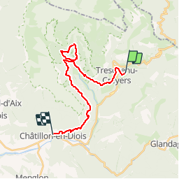
Tocht Stappen van 22 km beschikbaar op Auvergne-Rhône-Alpes, Drôme, Châtillon-en-Diois. Deze tocht wordt voorgesteld door tracegps.
Beschrijving
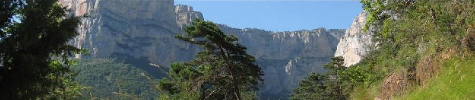
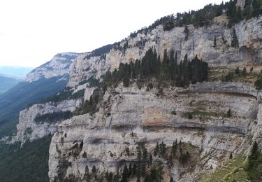
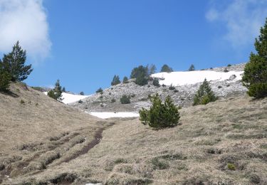
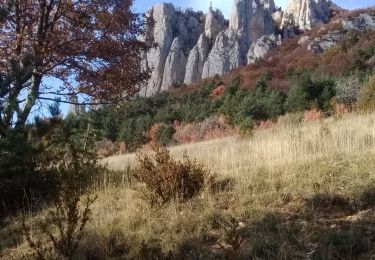
GTV - Tour du Vercors à pied - Les Nonnières - Châtillon en Diois. Ce tronçon donne l’occasion de visiter le cirque d’Archiane, l’un des sites phare du Vercors. L’itinéraire, sans difficulté notable, emprunte un chemin forestier depuis Les Nonnières jusqu’à Benevise, puis un joli sentier de Benevise à Archiane, et enfin une piste d’Archiane à Châtillon en Diois. Archiane est une des portes les plus importantes pour accéder à la Réserve des Grands Plateaux. Tracé officiel labellisé GTV. Le découpage proposé est indicatif et les tronçons ne sont pas imposés. Construisez autour votre propre itinéraire en fonction de votre forme physique et des conditions climatiques. Pour vous aider, consultez les informations de Vercors-GTV.com et retrouvez les itinéraires en détail dans les topo-guides du Parc.
Plaatsbepaling
Opmerkingen
Wandeltochten in de omgeving
![Stappen Stappen](https://static1.geolcdn.com/sitytour/trail-icons/101.png)
Stappen
![](/images/other/stat-length.png)
![](https://static1.geolcdn.com/siteimages/upload/files/16400158638029165_repeat_loop_refresh_sync_direction_icon.png)
![Tocht Stappen Châtillon-en-Diois - 2015-05-30 11:51 - Photo](https://media.geolcdn.com/t/375/260/f6b04bda-399a-4e8f-a718-7c3ac5f32c3c.jpg&format=jpg&maxdim=2)
![Stappen Stappen](https://static1.geolcdn.com/sitytour/trail-icons/101.png)
Stappen
![](/images/other/stat-length.png)
![](https://static1.geolcdn.com/siteimages/upload/files/16400158638029165_repeat_loop_refresh_sync_direction_icon.png)
![Stappen Stappen](https://static1.geolcdn.com/sitytour/trail-icons/101.png)
Stappen
![](/images/other/stat-length.png)
![](https://static1.geolcdn.com/siteimages/upload/files/16400158638029165_repeat_loop_refresh_sync_direction_icon.png)
![Tocht Stappen Châtillon-en-Diois - F26 Combau Fontaine Pourrie - Photo](https://media.geolcdn.com/t/375/260/ext.jpg?maxdim=2&url=https%3A%2F%2Fservices.sitytrail.com%2FGeolivesWS%2FDownloadMedia.ashx%3FTrailID%3D311756%26Media%3Dfix__20140611142210.jpg)
![Stappen Stappen](https://static1.geolcdn.com/sitytour/trail-icons/101.png)
Stappen
![](/images/other/stat-length.png)
![](https://static1.geolcdn.com/siteimages/upload/files/16400158638029165_repeat_loop_refresh_sync_direction_icon.png)
![Tocht Stappen Châtillon-en-Diois - 26 vallon combeau - Photo](https://media.geolcdn.com/t/375/260/5dff522d-7866-41ae-b85a-1900434d82e5.jpg&format=jpg&maxdim=2)
![Stappen Stappen](https://static1.geolcdn.com/sitytour/trail-icons/101.png)
Stappen
![](/images/other/stat-length.png)
![](https://static1.geolcdn.com/siteimages/upload/files/16400158638029165_repeat_loop_refresh_sync_direction_icon.png)
![Tocht Stappen Châtillon-en-Diois - 26 grimone j1 - Photo](https://media.geolcdn.com/t/375/260/781a4ae6-6994-4c28-83c7-bfb5368271f2.jpg&format=jpg&maxdim=2)
![Stappen Stappen](https://static1.geolcdn.com/sitytour/trail-icons/101.png)
Stappen
![](/images/other/stat-length.png)
![](https://static1.geolcdn.com/siteimages/upload/files/16400158638029165_repeat_loop_refresh_sync_direction_icon.png)
![Tocht Stappen Châtillon-en-Diois - Les crêtes du cirque d'Archiane - Photo](https://media.geolcdn.com/t/375/260/09133ccd-d124-4373-a8e4-85c1f4032737.jpg&format=jpg&maxdim=2)
![Stappen Stappen](https://static1.geolcdn.com/sitytour/trail-icons/101.png)
Stappen
![](/images/other/stat-length.png)
![](https://static1.geolcdn.com/siteimages/upload/files/16400158638029165_repeat_loop_refresh_sync_direction_icon.png)
![Tocht Stappen Châtillon-en-Diois - 2017-06-04 15:45:22 - Photo](https://media.geolcdn.com/t/375/260/4049bbeb-10e6-465f-8c97-cefb4daee153.jpg&format=jpg&maxdim=2)
![Stappen Stappen](https://static1.geolcdn.com/sitytour/trail-icons/101.png)
Stappen
![](/images/other/stat-length.png)
![](https://static1.geolcdn.com/siteimages/upload/files/16400158638029165_repeat_loop_refresh_sync_direction_icon.png)
![Tocht Stappen Châtillon-en-Diois - La boucle du Mont Barral - Photo](https://media.geolcdn.com/t/375/260/ext.jpg?maxdim=2&url=https%3A%2F%2Fservices.sitytrail.com%2FGeolivesWS%2FDownloadMedia.ashx%3FTrailID%3D634749%26Media%3Dc20ca353-82d8-44c0-a4a4-ad6f8b92275b.JPG)
![Stappen Stappen](https://static1.geolcdn.com/sitytour/trail-icons/101.png)
Stappen
![](/images/other/stat-length.png)
![](https://static1.geolcdn.com/siteimages/upload/files/16400158638029165_repeat_loop_refresh_sync_direction_icon.png)