Tocht Fiets Mailly-le-Camp - La Plaine Champenoise - Mailly le Camp - Photo

La Plaine Champenoise - Mailly le Camp

 tracegps
tracegps

Gebruiker

© OpenStreetMap contributors
Lengte
Lengte
66 km
Max. hoogte
Max. hoogte
164 m
Positief hoogteverschil
343 m
Km-Effort
Km-Effort  
71 km
Min. hoogte
Min. hoogte
79 m
Negatief hoogteverschil
345 m
Boucle
Boucle
Ja
Datum van aanmaak :
2014-12-10 00:00:00.0
Laatste wijziging :
2014-12-10 00:00:00.0

(0 Bericht)

Fiets
Fiets
2h30
Moeilijkheid : Medium

Scan deze QR-code om de tocht te openen in de SityTrail-applicatie

Gratisgps-wandelapplicatie

Logo SityTrail SityTrail

IGN / Geografische instituten

SityTrail uit de App Store downloaden SityTrail uit Google Play downloaden

Logo SityTrail SityTrail World

De wereld gaat voor u open

SityTrail uit de App Store downloaden SityTrail uit Google Play downloaden SityTrail op Huawei AppGallery downloaden

Over ons

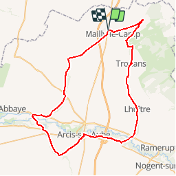
Tocht Fiets van 66 km beschikbaar op Grand Est, Aube, Mailly-le-Camp. Deze tocht wordt voorgesteld door tracegps.

Beschrijving

Proposé par le Comité Départemental du Tourisme de l'Aube, un circuit créé et validé par la Fédération Départementale du Cyclotourisme de l’Aube. La Plaine Champenoise – 65 km - Église Sainte Tanche de Lhuître - Vallée de l’Aube - Église Saint-Etienne d’Arcis-sur-Aube

Hoogteprofiel

Foto's

POI's

POI Mailly-le-Camp - cycloguide N?14 La Plaine Champenoise 66.174 km - Photo
tracegps

Plaatsbepaling

Land:
France
Regio :
Grand Est
Departement/Provincie :
Aube
Gemeente :
Mailly-le-Camp
Locatie:
Unknown
Vertrek:(Dec)
Vertrek:(UTM)
587701 ; 5392006 (31U) N.

Wandeltochten in de omgeving

Tocht Fiets Mailly-le-Camp - de Mailly-le-camp à chelles - Photo
Fiets
destras

Fiets

Medium
Mailly-le-Camp, Grand Est, Aube, France
139 km | 156 km-effort
6h 40min
Neen


Sluiten
Mijn abonnementen