![](/images/other/stat-length.png)
![Tocht Stappen Plumelec - Circuit de la Grée - Plumelec - Photo](https://media.geolcdn.com/t/1900/400/ext.pjpeg?maxdim=2&url=https%3A%2F%2Fstatic1.geolcdn.com%2Fsiteimages%2Fupload%2Ffiles%2F1553511878bg_sport_marche.png)
Circuit de la Grée - Plumelec
tracegps
Gebruiker
![Lengte](/images/other/stat-length.png)
![Max. hoogte](https://static1.geolcdn.com/siteimages/upload/files/1508320355ic_sort_altitude_max_24dp.png)
![Positief hoogteverschil](https://static1.geolcdn.com/siteimages/upload/files/1508320355ic_sort_den_pos_24dp.png)
![Km-Effort](/images/other/stat-length.png)
![Min. hoogte](https://static1.geolcdn.com/siteimages/upload/files/1508320355ic_sort_altitude_min_24dp.png)
![Negatief hoogteverschil](https://static1.geolcdn.com/siteimages/upload/files/1508320355ic_sort_den_neg_24dp.png)
![Boucle](https://static1.geolcdn.com/siteimages/upload/files/16400158638029165_repeat_loop_refresh_sync_direction_icon.png)
![Stappen](https://static1.geolcdn.com/sitytour/trail-icons/101.png)
3h00
Moeilijkheid : Medium
![Scan deze QR-code om de tocht te openen in de SityTrail-applicatie](https://capi.geolives.com/qq0zvz2zws4bq2lad0pu/sitytour/trails/112537/qr.png?size=200)
Gratisgps-wandelapplicatie
Over ons
Tocht Stappen van 4,4 km beschikbaar op Bretagne, Morbihan, Plumelec. Deze tocht wordt voorgesteld door tracegps.
Beschrijving
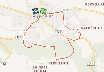
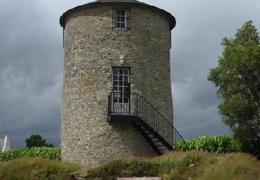
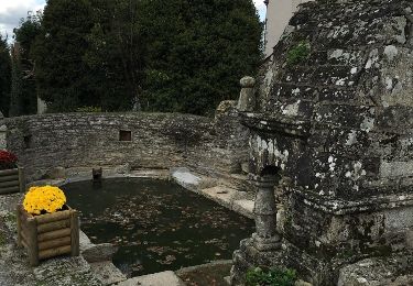
Point de départ : La Grée (Commune de Plumelec) - (coordonnées GPS : 02° 38’ 35’’ O / 47° 50’ 00’’ N) - DISTANCE : 12 km (3h00) A voir en chemin: Le site de la Grée : vue panoramique sur la vallée de la Claie. On y trouve aussi un moulin, une statue ainsi qu’un mémorial des parachutistes SAS. Le village de Cadoudal : une habitation de style renaissance portant la date de 1699 est encore présente. Côte de Cadoudal célèbre pour les courses cyclistes. La vallée de la Claie : la Claie est une rivière de première catégorie, longue de 63 kms qui traverse 13 communes du Morbihan. La croix Bouétard : monument érigé en l’honneur du caporal Bouétard, premier mort des troupes alliées parachutées pour organiser la libération de la France.
Plaatsbepaling
Opmerkingen
Wandeltochten in de omgeving
![Tocht Fiets Plumelec - Le petit Codoudal - Plumelec - Photo](https://media.geolcdn.com/t/375/260/ext.jpg?maxdim=2&url=https%3A%2F%2Fservices.sitytrail.com%2FGeolivesWS%2FDownloadMedia.ashx%3FTrailID%3D105596%26Media%3D9365_3.jpg)
![Fiets Fiets](https://static1.geolcdn.com/sitytour/trail-icons/200.png)
Fiets
![](/images/other/stat-length.png)
![](https://static1.geolcdn.com/siteimages/upload/files/16400158638029165_repeat_loop_refresh_sync_direction_icon.png)
![Tocht Stappen Trédion - PR_56_Tredion_AA_01_Circuit1b_De-Villeneuve_20240519 - Photo](https://media.geolcdn.com/t/375/260/c178189c-f1c8-404e-a35a-7868f9bf64c4.jpg&format=jpg&maxdim=2)
![Stappen Stappen](https://static1.geolcdn.com/sitytour/trail-icons/101.png)
Stappen
![](/images/other/stat-length.png)
![](https://static1.geolcdn.com/siteimages/upload/files/16400158638029165_repeat_loop_refresh_sync_direction_icon.png)
![Tocht Stappen Plumelec - PR_56_Plumelec_AA_01_Circuit1b_Des-Carrieres_20231128 - Photo](https://media.geolcdn.com/t/375/260/52ebcca8-2a99-449e-a08e-c4d2788c3393.jpg&format=jpg&maxdim=2)
![Stappen Stappen](https://static1.geolcdn.com/sitytour/trail-icons/101.png)
Stappen
![](/images/other/stat-length.png)
![](https://static1.geolcdn.com/siteimages/upload/files/16400158638029165_repeat_loop_refresh_sync_direction_icon.png)
![Tocht Stappen Plumelec - Plumelec Cadoudal - Photo](https://media.geolcdn.com/t/375/260/4527036b-5a44-46cb-b500-7c0d80d36167.jpg&format=jpg&maxdim=2)
![Stappen Stappen](https://static1.geolcdn.com/sitytour/trail-icons/101.png)
Stappen
![](/images/other/stat-length.png)
![](https://static1.geolcdn.com/siteimages/upload/files/16400158638029165_repeat_loop_refresh_sync_direction_icon.png)
![Tocht Stappen Billio - billio - Photo](https://media.geolcdn.com/t/375/260/a9b1cb88-c5f7-4327-9462-f17f98b981b8.jpg&format=jpg&maxdim=2)
![Stappen Stappen](https://static1.geolcdn.com/sitytour/trail-icons/101.png)
![Tocht Stappen Cruguel - Guegon - Circuit des Picouras - Photo](https://media.geolcdn.com/t/375/260/ext.jpg?maxdim=2&url=https%3A%2F%2Fservices.sitytrail.com%2FGeolivesWS%2FDownloadMedia.ashx%3FTrailID%3D492161%26Media%3D20151110140037.jpg)
![Stappen Stappen](https://static1.geolcdn.com/sitytour/trail-icons/101.png)
Stappen
![](/images/other/stat-length.png)
![](https://static1.geolcdn.com/siteimages/upload/files/16400158638029165_repeat_loop_refresh_sync_direction_icon.png)
![Tocht Stappen Plumelec - Plumelec carrières - Photo](https://media.geolcdn.com/t/375/260/a6dfc2c0-638c-4143-95c8-fe1761aa1680.jpg&format=jpg&maxdim=2)
![Stappen Stappen](https://static1.geolcdn.com/sitytour/trail-icons/101.png)
Stappen
![](/images/other/stat-length.png)
![](https://static1.geolcdn.com/siteimages/upload/files/16400158638029165_repeat_loop_refresh_sync_direction_icon.png)
![Tocht Te voet Trédion - Circuit de Villeneuve, Trédion - Photo](https://media.geolcdn.com/t/375/260/ext.jpg?maxdim=2&url=https%3A%2F%2Fstatic1.geolcdn.com%2Fsiteimages%2Fupload%2Ffiles%2F1545311037marcheuse_200dpi.jpg)
![Te voet Te voet](https://static1.geolcdn.com/sitytour/trail-icons/100.png)
Te voet
![](/images/other/stat-length.png)
![](https://static1.geolcdn.com/siteimages/upload/files/16400158638029165_repeat_loop_refresh_sync_direction_icon.png)
![Tocht Te voet Trédion - GRP© Trédion à Le Cours - Photo](https://media.geolcdn.com/t/375/260/ext.jpg?maxdim=2&url=https%3A%2F%2Fstatic1.geolcdn.com%2Fsiteimages%2Fupload%2Ffiles%2F1545311037marcheuse_200dpi.jpg)
![Te voet Te voet](https://static1.geolcdn.com/sitytour/trail-icons/100.png)
Te voet
![](/images/other/stat-length.png)
![](https://static1.geolcdn.com/siteimages/upload/files/16400158638029165_repeat_loop_refresh_sync_direction_icon.png)