![](/images/other/stat-length.png)
![Tocht Stappen Montreuil-le-Gast - Circuit de Montboucher - Montreuil-le-Gast - Photo](https://media.geolcdn.com/t/1900/400/ext.pjpeg?maxdim=2&url=https%3A%2F%2Fservices.sitytrail.com%2FGeolivesWS%2FDownloadMedia.ashx%3FTrailID%3D112324%26Media%3D10338_3.jpg)
Circuit de Montboucher - Montreuil-le-Gast
tracegps
Gebruiker
![Lengte](/images/other/stat-length.png)
![Max. hoogte](https://static1.geolcdn.com/siteimages/upload/files/1508320355ic_sort_altitude_max_24dp.png)
![Positief hoogteverschil](https://static1.geolcdn.com/siteimages/upload/files/1508320355ic_sort_den_pos_24dp.png)
![Km-Effort](/images/other/stat-length.png)
![Min. hoogte](https://static1.geolcdn.com/siteimages/upload/files/1508320355ic_sort_altitude_min_24dp.png)
![Negatief hoogteverschil](https://static1.geolcdn.com/siteimages/upload/files/1508320355ic_sort_den_neg_24dp.png)
![Boucle](https://static1.geolcdn.com/siteimages/upload/files/16400158638029165_repeat_loop_refresh_sync_direction_icon.png)
![Stappen](https://static1.geolcdn.com/sitytour/trail-icons/101.png)
2h34
Moeilijkheid : Medium
![Scan deze QR-code om de tocht te openen in de SityTrail-applicatie](https://capi.geolives.com/qq0zvz2zws4bq2lad0pu/sitytour/trails/112324/qr.png?size=200)
Gratisgps-wandelapplicatie
Over ons
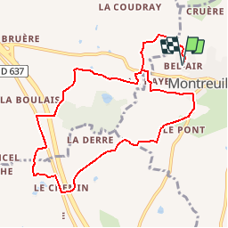
Tocht Stappen van 10,5 km beschikbaar op Bretagne, Ille-et-Vilaine, Montreuil-le-Gast. Deze tocht wordt voorgesteld door tracegps.
Beschrijving
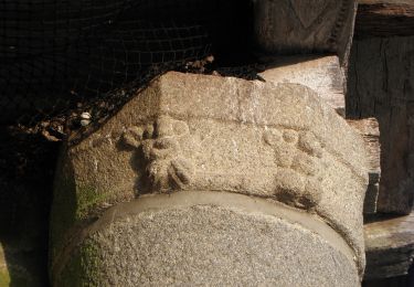
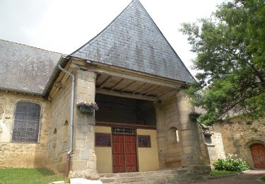
Circuit proposé par la Communauté de Communes du Val d’Ille. Départ de la ferme équestre de Bel Air. Montboucher fut le berceau d’une grande famille « de Montboucher ». Déjà cité en 1040, ils étaient parmi les croisés de Saint-Louis. La «Motte à Madame» enceinte défensive terroyée, encore présente à l’ouest du bois (privé), date sans doute du XIe siècle. Retrouvez la fiche du circuit sur le site de la Communauté de Communes du Val d’Ille.
Plaatsbepaling
Opmerkingen
Wandeltochten in de omgeving
![Tocht Te voet Melesse - Sentier des Melessiens - Photo](https://media.geolcdn.com/t/375/260/0f30e474-f118-48a0-a59b-66ca1ed3bb91.jpeg&format=jpg&maxdim=2)
![Te voet Te voet](https://static1.geolcdn.com/sitytour/trail-icons/100.png)
Te voet
![](/images/other/stat-length.png)
![](https://static1.geolcdn.com/siteimages/upload/files/16400158638029165_repeat_loop_refresh_sync_direction_icon.png)
![Tocht Te voet Saint-Médard-sur-Ille - Le Bois de Cranne - Photo](https://media.geolcdn.com/t/375/260/d1c048d2-ce9b-4bbc-8166-22a8dfba9cca.jpeg&format=jpg&maxdim=2)
![Te voet Te voet](https://static1.geolcdn.com/sitytour/trail-icons/100.png)
Te voet
![](/images/other/stat-length.png)
![](https://static1.geolcdn.com/siteimages/upload/files/16400158638029165_repeat_loop_refresh_sync_direction_icon.png)
![Tocht Te voet Montreuil-le-Gast - La Fosse du Loup - Photo](https://media.geolcdn.com/t/375/260/23710b22-992a-44ea-99ef-dabc47ec71b0.jpeg&format=jpg&maxdim=2)
![Te voet Te voet](https://static1.geolcdn.com/sitytour/trail-icons/100.png)
Te voet
![](/images/other/stat-length.png)
![](https://static1.geolcdn.com/siteimages/upload/files/16400158638029165_repeat_loop_refresh_sync_direction_icon.png)
![Tocht Te voet La Mézière - Circuit de La Rivière - Photo](https://media.geolcdn.com/t/375/260/effb608e-9523-4c80-8eff-d9597a799e45.jpeg&format=jpg&maxdim=2)
![Te voet Te voet](https://static1.geolcdn.com/sitytour/trail-icons/100.png)
Te voet
![](/images/other/stat-length.png)
![](https://static1.geolcdn.com/siteimages/upload/files/16400158638029165_repeat_loop_refresh_sync_direction_icon.png)
![Tocht Te voet Gévezé - Circuit du Cheval Blanc - Photo](https://media.geolcdn.com/t/375/260/6a65d215-7eed-44b7-9d26-d5e20ab6f1d2.jpeg&format=jpg&maxdim=2)
![Te voet Te voet](https://static1.geolcdn.com/sitytour/trail-icons/100.png)
Te voet
![](/images/other/stat-length.png)
![](https://static1.geolcdn.com/siteimages/upload/files/16400158638029165_repeat_loop_refresh_sync_direction_icon.png)
![Tocht Te voet Gévezé - Sentier de la Chaussée - Photo](https://media.geolcdn.com/t/375/260/b68bfa03-18ec-4b2e-a7fc-64dc0a472980.jpeg&format=jpg&maxdim=2)
![Te voet Te voet](https://static1.geolcdn.com/sitytour/trail-icons/100.png)
Te voet
![](/images/other/stat-length.png)
![](https://static1.geolcdn.com/siteimages/upload/files/16400158638029165_repeat_loop_refresh_sync_direction_icon.png)
![Tocht Te voet La Mézière - Sentier de Montgerval - Photo](https://media.geolcdn.com/t/375/260/f85f597a-f5d9-4626-9ff3-a4f1fc6b4cfc.jpeg&format=jpg&maxdim=2)
![Te voet Te voet](https://static1.geolcdn.com/sitytour/trail-icons/100.png)
Te voet
![](/images/other/stat-length.png)
![](https://static1.geolcdn.com/siteimages/upload/files/16400158638029165_repeat_loop_refresh_sync_direction_icon.png)
![Tocht Te voet Gévezé - Circuit du Moulin de la Moltais - Photo](https://media.geolcdn.com/t/375/260/0b61b143-c705-414e-8194-5fcc4095b5f1.jpeg&format=jpg&maxdim=2)
![Te voet Te voet](https://static1.geolcdn.com/sitytour/trail-icons/100.png)
Te voet
![](/images/other/stat-length.png)
![](https://static1.geolcdn.com/siteimages/upload/files/16400158638029165_repeat_loop_refresh_sync_direction_icon.png)
![Tocht Te voet Gévezé - Circuit de la Motte Marcillé - Photo](https://media.geolcdn.com/t/375/260/92a5fd14-c2a6-4b26-bc47-2f8fa78eecb4.jpeg&format=jpg&maxdim=2)
![Te voet Te voet](https://static1.geolcdn.com/sitytour/trail-icons/100.png)
Te voet
![](/images/other/stat-length.png)
![](https://static1.geolcdn.com/siteimages/upload/files/16400158638029165_repeat_loop_refresh_sync_direction_icon.png)