![](/images/other/stat-length.png)
![Tocht Stappen Melesse - Sentier de l'Ille - Saint-Germain-sur-Ille - Photo](https://media.geolcdn.com/t/1900/400/ext.pjpeg?maxdim=2&url=https%3A%2F%2Fservices.sitytrail.com%2FGeolivesWS%2FDownloadMedia.ashx%3FTrailID%3D112322%26Media%3D10337_3.jpg)
Sentier de l'Ille - Saint-Germain-sur-Ille
tracegps
Gebruiker
![Lengte](/images/other/stat-length.png)
Lengte
13,1 km
![Max. hoogte](https://static1.geolcdn.com/siteimages/upload/files/1508320355ic_sort_altitude_max_24dp.png)
Max. hoogte
113 m
![Positief hoogteverschil](https://static1.geolcdn.com/siteimages/upload/files/1508320355ic_sort_den_pos_24dp.png)
Positief hoogteverschil
158 m
![Km-Effort](/images/other/stat-length.png)
Km-Effort
15,2 km
![Min. hoogte](https://static1.geolcdn.com/siteimages/upload/files/1508320355ic_sort_altitude_min_24dp.png)
Min. hoogte
44 m
![Negatief hoogteverschil](https://static1.geolcdn.com/siteimages/upload/files/1508320355ic_sort_den_neg_24dp.png)
Negatief hoogteverschil
158 m
![Boucle](https://static1.geolcdn.com/siteimages/upload/files/16400158638029165_repeat_loop_refresh_sync_direction_icon.png)
Boucle
Ja
Datum van aanmaak :
2014-12-10 00:00:00.0
Laatste wijziging :
2014-12-10 00:00:00.0
![Stappen](https://static1.geolcdn.com/sitytour/trail-icons/101.png)
3h15
Moeilijkheid : Moeilijk
![Scan deze QR-code om de tocht te openen in de SityTrail-applicatie](https://capi.geolives.com/qq0zvz2zws4bq2lad0pu/sitytour/trails/112322/qr.png?size=200)
Gratisgps-wandelapplicatie
Over ons
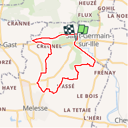
Tocht Stappen van 13,1 km beschikbaar op Bretagne, Ille-et-Vilaine, Melesse. Deze tocht wordt voorgesteld door tracegps.
Beschrijving
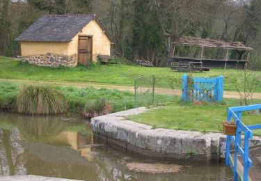
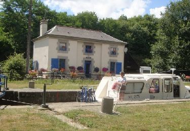
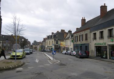
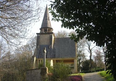
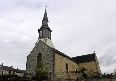
Circuit proposé par la Communauté de Communes du Val d’Ille. Départ de La ville en Bois à Saint-Germain-sur-Ille. Le parcours permet d’avoir un apercu du patrimoine bâti. Retrouvez la fiche du circuit sur le site de la Communauté de Communes du Val d’Ille.
Plaatsbepaling
Land:
France
Regio :
Bretagne
Departement/Provincie :
Ille-et-Vilaine
Gemeente :
Melesse
Locatie:
Unknown
Vertrek:(Dec)
Vertrek:(UTM)
598894 ; 5344752 (30U) N.
Opmerkingen
Wandeltochten in de omgeving
![Tocht Stappen Saint-Germain-sur-Ille - Sentier des Roches - Saint-Germain-sur-Ille - Photo](https://media.geolcdn.com/t/375/260/ext.jpg?maxdim=2&url=https%3A%2F%2Fservices.sitytrail.com%2FGeolivesWS%2FDownloadMedia.ashx%3FTrailID%3D112637%26Media%3D11326_2.jpg)
![Stappen Stappen](https://static1.geolcdn.com/sitytour/trail-icons/101.png)
Sentier des Roches - Saint-Germain-sur-Ille
Stappen
Medium
(1)
Saint-Germain-sur-Ille,
Bretagne,
Ille-et-Vilaine,
France
![](/images/other/stat-length.png)
9,2 km | 11,3 km-effort
2h 19min
![](https://static1.geolcdn.com/siteimages/upload/files/16400158638029165_repeat_loop_refresh_sync_direction_icon.png)
Ja
![Tocht Mountainbike Saint-Médard-sur-Ille - Sentier du Bois de Cranne - Saint-Médard-sur-Ille - Photo](https://media.geolcdn.com/t/375/260/ext.jpg?maxdim=2&url=https%3A%2F%2Fservices.sitytrail.com%2FGeolivesWS%2FDownloadMedia.ashx%3FTrailID%3D112570%26Media%3D10980_2.jpg)
![Mountainbike Mountainbike](https://static1.geolcdn.com/sitytour/trail-icons/202.png)
Sentier du Bois de Cranne - Saint-Médard-sur-Ille
Mountainbike
Gemakkelijk
(1)
Saint-Médard-sur-Ille,
Bretagne,
Ille-et-Vilaine,
France
![](/images/other/stat-length.png)
14,6 km | 16,9 km-effort
1h 19min
![](https://static1.geolcdn.com/siteimages/upload/files/16400158638029165_repeat_loop_refresh_sync_direction_icon.png)
Ja
![Tocht Te voet Melesse - Sentier des Melessiens - Photo](https://media.geolcdn.com/t/375/260/0f30e474-f118-48a0-a59b-66ca1ed3bb91.jpeg&format=jpg&maxdim=2)
![Te voet Te voet](https://static1.geolcdn.com/sitytour/trail-icons/100.png)
Sentier des Melessiens
Te voet
Gemakkelijk
Melesse,
Bretagne,
Ille-et-Vilaine,
France
![](/images/other/stat-length.png)
8,5 km | 9,6 km-effort
2h 10min
![](https://static1.geolcdn.com/siteimages/upload/files/16400158638029165_repeat_loop_refresh_sync_direction_icon.png)
Ja
![Tocht Te voet Saint-Médard-sur-Ille - Le Bois de Cranne - Photo](https://media.geolcdn.com/t/375/260/d1c048d2-ce9b-4bbc-8166-22a8dfba9cca.jpeg&format=jpg&maxdim=2)
![Te voet Te voet](https://static1.geolcdn.com/sitytour/trail-icons/100.png)
Le Bois de Cranne
Te voet
Gemakkelijk
Saint-Médard-sur-Ille,
Bretagne,
Ille-et-Vilaine,
France
![](/images/other/stat-length.png)
14,4 km | 16,6 km-effort
3h 45min
![](https://static1.geolcdn.com/siteimages/upload/files/16400158638029165_repeat_loop_refresh_sync_direction_icon.png)
Ja
![Tocht Te voet Montreuil-le-Gast - La Fosse du Loup - Photo](https://media.geolcdn.com/t/375/260/23710b22-992a-44ea-99ef-dabc47ec71b0.jpeg&format=jpg&maxdim=2)
![Te voet Te voet](https://static1.geolcdn.com/sitytour/trail-icons/100.png)
La Fosse du Loup
Te voet
Medium
Montreuil-le-Gast,
Bretagne,
Ille-et-Vilaine,
France
![](/images/other/stat-length.png)
18,3 km | 21 km-effort
4h 51min
![](https://static1.geolcdn.com/siteimages/upload/files/16400158638029165_repeat_loop_refresh_sync_direction_icon.png)
Ja
![Tocht Te voet Saint-Médard-sur-Ille - Circuit de Saint-Médard - Photo](https://media.geolcdn.com/t/375/260/1db7e459-0d11-4a34-9758-09e2168028ed.jpeg&format=jpg&maxdim=2)
![Te voet Te voet](https://static1.geolcdn.com/sitytour/trail-icons/100.png)
Circuit de Saint-Médard
Te voet
Gemakkelijk
Saint-Médard-sur-Ille,
Bretagne,
Ille-et-Vilaine,
France
![](/images/other/stat-length.png)
10,2 km | 11,9 km-effort
2h 41min
![](https://static1.geolcdn.com/siteimages/upload/files/16400158638029165_repeat_loop_refresh_sync_direction_icon.png)
Ja
![Tocht Te voet Guipel - Sentier de la Normandière - Photo](https://media.geolcdn.com/t/375/260/9517ac36-a7c5-49a5-915a-49060e792ae7.jpeg&format=jpg&maxdim=2)
![Te voet Te voet](https://static1.geolcdn.com/sitytour/trail-icons/100.png)
Sentier de la Normandière
Te voet
Gemakkelijk
Guipel,
Bretagne,
Ille-et-Vilaine,
France
![](/images/other/stat-length.png)
10,5 km | 11,5 km-effort
2h 36min
![](https://static1.geolcdn.com/siteimages/upload/files/16400158638029165_repeat_loop_refresh_sync_direction_icon.png)
Ja
![Tocht Te voet Chevaigné - Chemin des Amoureux - Photo](https://media.geolcdn.com/t/375/260/fa6c7e86-676b-401e-ab74-8e6f4b9fd786.jpeg&format=jpg&maxdim=2)
![Te voet Te voet](https://static1.geolcdn.com/sitytour/trail-icons/100.png)
Chemin des Amoureux
Te voet
Gemakkelijk
Chevaigné,
Bretagne,
Ille-et-Vilaine,
France
![](/images/other/stat-length.png)
5,1 km | 5,8 km-effort
1h 18min
![](https://static1.geolcdn.com/siteimages/upload/files/16400158638029165_repeat_loop_refresh_sync_direction_icon.png)
Ja
![Tocht Te voet Chevaigné - Circuit du Breil - Photo](https://media.geolcdn.com/t/375/260/05f060df-ea1f-4584-b6b8-c74ea796456e.jpeg&format=jpg&maxdim=2)
![Te voet Te voet](https://static1.geolcdn.com/sitytour/trail-icons/100.png)
Circuit du Breil
Te voet
Gemakkelijk
Chevaigné,
Bretagne,
Ille-et-Vilaine,
France
![](/images/other/stat-length.png)
7,2 km | 8,2 km-effort
1h 52min
![](https://static1.geolcdn.com/siteimages/upload/files/16400158638029165_repeat_loop_refresh_sync_direction_icon.png)
Ja